FAA INFORMATION EFFECTIVE 02 OCTOBER 2025
Location
| FAA Identifier: | GPT |
| Lat/Long: | 30-24-26.1690N 089-04-12.3450W
30-24.436150N 089-04.205750W
30.4072692,-89.0700958
(estimated) |
| Elevation: | 28 ft. / 8.5 m (surveyed) |
| Variation: | 02W (2020) |
| From city: | 3 miles NE of GULFPORT, MS |
| Time zone: | UTC -5 (UTC -6 during Standard Time) |
| Zip code: | 39501 |
Airport Operations
| Airport use: | Open to the public |
| Control tower: | yes |
| ARTCC: | HOUSTON CENTER |
| FSS: | GREENWOOD FLIGHT SERVICE STATION |
| NOTAMs facility: | GPT (NOTAM-D service available) |
| Attendance: | CONTINUOUS |
| Pattern altitude: | 828 ft. MSL
TPA: 800 FT AGL LGT SNGL-ENG, 1200 FT AGL CONVENTIONAL, 1500 FT AGL JETS. |
| Wind indicator: | lighted |
| Segmented circle: | yes |
| Lights: | WHEN ATCT CLSD ACTVT MALSR RWY 14 & 32; HIRL RWY 14/32; MIRL RWY 18/36 - CTAF. MIRL RWY 18/36 NOT AVBL WHEN ATCT CLSD & RWY 14/32 ACTV. |
| Beacon: | white-green (lighted land airport)
Operates sunset to sunrise. |
| Fire and rescue: | ARFF index B |
| International operations: | customs landing rights airport |
Airport Communications
| CTAF: | 123.7 |
| UNICOM: | 122.95 |
| ATIS: | 119.45 |
| WX ASOS: | 119.45 (228-867-9937) |
| GULFPORT GROUND: | 120.4 348.6 [0600-2300] |
| GULFPORT TOWER: | 123.7 339.8 [0600-2300] |
| GULFPORT APPROACH: | 124.6 ;130-309 127.5 ;310-129 254.25 ;310-129 354.1 ;130-309 [0600-2300] |
| GULFPORT DEPARTURE: | 124.6 ;130-309 127.5 ;310-129 254.25 ;310-129 354.1 ;130-309 [0600-2300] |
| EMERG: | 121.5 243.0 |
| FINAL CTL: | 126.75 397.95 |
| IC: | 127.5 ;310-129 254.25 ;310-129 |
| TRSA: | 124.6 ;130-309 127.5 ;310-129 254.25 ;310-129 354.1 ;130-309 |
- APCH/DEP SVC PRVDD BY HOUSTON ARTCC (ZHU) ON FREQS 127.65/285.475 (MOBILE RCAG) WHEN GULFPORT APCH CTL (GPT) CLSD.
Nearby radio navigation aids
| VOR radial/distance | | VOR name | | Freq | | Var |
|---|
| GPT at field | | GULFPORT VORTAC | | 109.00 | | 02E |
| PCUr100/35.4 | | PICAYUNE VOR/DME | | 113.95 | | 05E |
| NDB name | | Hdg/Dist | | Freq | | Var | | ID |
|---|
| BAYOU | | 137/6.7 | | 360 | | 02W | | GP | --. .--. |
Airport Services
| Fuel available: | 100LL JET-A JET-A+ |
| Parking: | hangars and tiedowns |
| Airframe service: | MAJOR |
| Powerplant service: | MAJOR |
| Bottled oxygen: | HIGH/LOW |
| Bulk oxygen: | NONE |
Runway Information
Runway 14/32
| Dimensions: | 9002 x 150 ft. / 2744 x 46 m |
| Surface: | asphalt/concrete/grooved, in good condition
RWY END 14 FIRST 2000 FT CONC; RWY END 32 FIRST 1500 FT CONC. |
| Weight bearing capacity: | | Single wheel: | 120.0, 2S-175. | | Double wheel: | 250.0 | | Double tandem: | 487.0 | | Dual double tandem: | 1010.0 |
|
| Runway edge lights: | high intensity |
| RUNWAY 14 | | RUNWAY 32 |
| Latitude: | 30-24.897290N | | 30-23.848725N |
| Longitude: | 089-04.938265W | | 089-03.725152W |
| Elevation: | 18.9 ft. | | 22.0 ft. |
| Traffic pattern: | left | | left |
| Runway heading: | 137 magnetic, 135 true | | 317 magnetic, 315 true |
| Markings: | precision, in good condition | | precision, in good condition |
| Visual slope indicator: | 4-light PAPI on right (3.00 degrees glide path) | | 4-light PAPI on left (3.00 degrees glide path) |
| RVR equipment: | touchdown | | touchdown |
| Approach lights: | MALSR: 1,400 foot medium intensity approach lighting system with runway alignment indicator lights | | MALSR: 1,400 foot medium intensity approach lighting system with runway alignment indicator lights |
| Runway end identifier lights: | no | | no |
| Touchdown point: | yes, no lights | | yes, no lights |
| Instrument approach: | ILS | | ILS |
Runway 18/36
| Dimensions: | 4935 x 150 ft. / 1504 x 46 m |
| Surface: | asphalt/grooved, in fair condition |
| Weight bearing capacity: | | Single wheel: | 120.0 | | Double wheel: | 232.0 | | Double tandem: | 394.0 | | Dual double tandem: | 923.0 |
|
| Runway edge lights: | medium intensity |
| Operational restrictions: | RWY 18/36 NOT AVBL FOR PART 121/PART 380 OPS WITH SKED PAX CARRYING OPS MORE THAN 9 PAX SEATS AND NON-SKED PAX CARRYING OPS MORE THAN 30 PAX SEATS. |
| RUNWAY 18 | | RUNWAY 36 |
| Latitude: | 30-24.958343N | | 30-24.144220N |
| Longitude: | 089-03.977465W | | 089-03.974762W |
| Elevation: | 23.5 ft. | | 25.5 ft. |
| Traffic pattern: | left | | left |
| Runway heading: | 182 magnetic, 180 true | | 002 magnetic, 360 true |
| Markings: | nonprecision, in good condition | | nonprecision, in good condition |
| Visual slope indicator: | 4-light PAPI on right (3.00 degrees glide path) | | 4-light PAPI on left (3.00 degrees glide path) |
| Runway end identifier lights: | no | | no |
| Touchdown point: | yes, no lights | | yes, no lights |
Airport Ownership and Management from official FAA records
| Ownership: | Publicly-owned |
| Owner: | GULFPORT-BILOXI RGNL APT AUTH
14035-L AIRPORT RD
GULFPORT, MS 39503
Phone 228-863-5951 |
| Manager: | CLAY WILLIAMS
14035-L AIRPORT RD
GULFPORT, MS 39503
Phone 228-863-5951 |
Additional Remarks
| A39-18/36 | PCR VALUE: 580/F/B/X/T |
| A39-14/32 | PCR VALUE: 960/R/C/W/T |
| E60-32 | BAK-14 BAK-12B(B) (1300 FT). |
| E60-14 | BAK-14 BAK-12B(B) (1800 FT). |
| - | NMRS LOW FLYING FISH SPOTTER ACFT OPERG THE SHORELINE BTN PASCAGOULA & GULFPORT SR-SS. |
| - | ACFT OPERG AS SKED OR CHTR PAX SVC SHALL NOT TAX ON TWY A N OF TWY B INT WO ESCORT FM GND HANDLING AGENT OR ARPT AUTH. |
| - | CIV ACFT WITH WINGSPAN OF 132 FT OR GTR & ALL ACR ACFT MUST BE ESCORTED ALG TWY A N OF TWY C BY GND HANDLING AGENT. |
| - | MIL ACFT OR ACFT SUPPORTING A MIL MISSION WITH WINGSPAN OF 132 FT OR GTR MUST HAVE ESCORT OR COORD TAX PROCS WITH GND HANDLING AGENT PRIOR TO TAX ON TWY A. |
| - | MAVERICK PAD APN AREA ON N END OF TWY C RSTRD TO MIL ACFT USE ONLY. |
| - | A-GEAR AVBL DRG ANG OPS WITH 30 MIN PPR. |
| - | CUST & IMG 48 HR PPR. |
| - | MILITARY: RSTD: C-5 ACFT PRKG RSTD TO 1 ACFT AT A TIME DUE TO TWY WID UNLESS COORDD. |
| - | MILITARY: ANG: NO COMSEC STOR. CRTC AFLD MGMT OPS OPR 1300-2130Z++ MON; 1300-2230Z++ TUES-FRI & UNIT TRNG ASSEMBLY (UTA) WKNDS, NORMALLY FIRST WKND OF MONTH; CLSD HOL. 48 HR PN PPR RQR CTC CRTC AM OPS. CTC GUARD OPS 15 MIN PRIOR TO ARR 377.800. DSN 363-6027; C228-214-6027; FAX DSN 363-6031; C228-214-6031. |
| - | MILITARY: CAUTION: BASH PHASE II IN EFCT APR-MAY AND AUG-OCT. CTC AFLD MGMT FOR CURRENT BIRD WATCH COND. |
| - | PWR CHK PAD BTN RWY 18/36 AND TWY A RSTD TO MIL ACFT ONLY. |
| - | TXL F20 BTN FBO & TXL G CLSD TO ACFT WITH WINGSPAN GTR THAN 49 FT. POLE ADJ TXL F20 NOT LGTD. |
| - | FUEL A+ (MIL) A (C228-701-0400). |
| - | MILITARY: RSTD: PRKG RSTD WI 100 FT LOX FAC LCTD NE CORNER APN 1. |
| - | MILITARY: ANG: LTD SVC AVBL, SPACE A PSNL, NO PAX TRML. |
| - | MILITARY: ARNG: MSAVCRAD OPS OPR 1300-2130Z++ MON; 1300-2230Z++ TUE-FRI & UNIT TRNG ASSEMBLY (UTA) WKND. PPR RQR CTC ARNG OPS, DSN 293-1378/1312, C228-214-1378/1312. ACFT INBD TO ARNG RAMP CTC BLACKJACK OPS (241.0/41.6) 10 MIN PRIOR TO LDG FOR PRK INSTR. |
| - | ACFT OVR 115000 LBS ARE RSTRD FM 180 DEG TURNS ON RWY 18/36. ACFT WITH WINGSPAN GTR THAN 223 FT ARE RSTRD FM OPRG ON TWY C BTN TWY A & AER 32. |
| - | ACFT OVR 155000 LBS ARE RSTRD FM USING THE N PART OF TWY A AT RWY 18/36. ACFT OVR 316000 LBS ARE RSTRD FM USING THE S PART OF TWY A BTN TWY C & RWY 14/32. |
| - | DUE TO APN ACTVTY ACFT WITH WINGSPAN GTR THAN 170 FT SHOULD BE ALERT ON TWY A BTN TWY C & TWY B. |
| - | 150 FT AGL CRANE 4600 FT N OF RWY 18 THLD. |
Instrument Procedures
NOTE: All procedures below are presented as PDF files. If you need a reader for these files, you should download the free Adobe Reader.NOT FOR NAVIGATION. Please procure official charts for flight.
FAA instrument procedures published for use from 02 October 2025 at 0901Z to 30 October 2025 at 0900z.
IAPs - Instrument Approach Procedures |
|---|
| HI-ILS Y OR LOC Y RWY 14 | |
download (194KB) |
| HI-ILS Y OR LOC Y RWY 32 | |
download (373KB) |
| ILS Z OR LOC Z RWY 14 **CHANGED** | |
download (273KB) |
| ILS Z OR LOC Z RWY 32 **CHANGED** | |
download (280KB) |
| ILS Z RWY 14 (SA CAT II) **CHANGED** | |
download (246KB) |
| RNAV (GPS) RWY 14 **CHANGED** | |
download (217KB) |
| RNAV (GPS) RWY 18 **CHANGED** | |
download (207KB) |
| RNAV (GPS) RWY 32 **CHANGED** | |
download (224KB) |
| RNAV (GPS) RWY 36 **CHANGED** | |
download (209KB) |
| VOR Y RWY 14 **CHANGED** | |
download (167KB) |
| VOR Y RWY 32 **CHANGED** | |
download (203KB) |
| VOR Z RWY 32 **CHANGED** | |
download (229KB) |
| VOR Z OR TACAN Z RWY 14 **CHANGED** | |
download (228KB) |
| HI-TACAN Y RWY 14 | |
download (182KB) |
| Radar Approach Procedures available | |
download (191KB) |
| NOTE: Special Alternate Minimums apply | |
download (159KB) |
| NOTE: Special Take-Off Minimums/Departure Procedures apply | |
download (311KB) |
Other nearby airports with instrument procedures:
KBIX - Keesler Air Force Base (8 nm E)
KHSA - Stennis International Airport (20 nm W)
M24 - Dean Griffin Memorial Airport (27 nm N)
KPQL - Trent Lott International Airport (28 nm E)
KMJD - Picayune Municipal Airport (30 nm W)
|
|

Road maps at:
MapQuest
Bing
Google
| Aerial photo |
|---|
WARNING: Photo may not be current or correct
 Photo by Jeff Harden
Photo taken 14-Feb-2008
Photo by Jeff Harden
Photo taken 14-Feb-2008
Do you have a better or more recent aerial photo of Gulfport-Biloxi International Airport that you would like to share? If so, please send us your photo.
|
| Sectional chart |
|---|
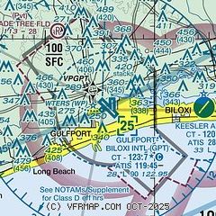
|
CAUTION: Diagram may not be current
 Download PDF
of official airport diagram from the FAA
| Airport distance calculator |
|---|
|
|
| Sunrise and sunset |
|---|
|
Times for 26-Oct-2025
| | Local
(UTC-5) | | Zulu
(UTC) |
|---|
| Morning civil twilight | | 06:43 | | 11:43 |
| Sunrise | | 07:07 | | 12:07 |
| Sunset | | 18:13 | | 23:13 |
| Evening civil twilight | | 18:38 | | 23:38 |
|
| Current date and time |
|---|
| Zulu (UTC) | 27-Oct-2025 04:12:10 |
|---|
| Local (UTC-5) | 26-Oct-2025 23:12:10 |
|---|
|
| METAR |
|---|
| KGPT | 270353Z AUTO 19003KT 10SM CLR 23/22 A2991 RMK AO2 SLP127 T02330217
|
KBIX
8nm E | 270355Z AUTO 20005KT 10SM CLR 23/21 A2989 RMK AO2 SLP125 T02330214
|
KHSA
20nm W | 270150Z 00000KT 10SM BKN015 21/20 A2992
|
|
| TAF |
|---|
| KGPT | 261739Z 2618/2718 16010KT P6SM SCT015 OVC050 TEMPO 2618/2619 2SM RA BR BKN015 FM270200 21006KT P6SM SCT020 BKN025 FM270500 VRB04KT P6SM BKN010 BKN015 FM270800 VRB04KT 4SM BR BKN003 BKN010 FM271400 33007KT P6SM SCT010
|
|
| NOTAMs |
|---|
NOTAMs are issued by the DoD/FAA and will open in a separate window not controlled by AirNav.
|
|


