FAA INFORMATION EFFECTIVE 09 JULY 2026
Location
| FAA Identifier: | GTU |
| Lat/Long: | 30-40-43.7000N 097-40-45.8000W
30-40.728333N 097-40.763333W
30.6788056,-97.6793889
(estimated) |
| Elevation: | 789.5 ft. / 240.6 m (surveyed) |
| Variation: | 06E (2000) |
| From city: | 3 miles N of GEORGETOWN, TX |
| Time zone: | UTC -5 (UTC -6 during Standard Time) |
| Zip code: | 78628 |
Airport Operations
| Airport use: | Open to the public |
| Activation date: | 10/1945 |
| Control tower: | yes |
| ARTCC: | HOUSTON CENTER |
| FSS: | SAN ANGELO FLIGHT SERVICE STATION |
| NOTAMs facility: | GTU (NOTAM-D service available) |
| Attendance: | 0700-1900 |
| Wind indicator: | lighted |
| Segmented circle: | yes |
| Lights: | AFT TWR HRS, MIRL RWY 18/36 PRESET LOW INTST; TO INCR INTST & ACTVT REILS RWY 18 & 36; MIRL RWY 11/29 - CTAF. |
| Beacon: | white-green (lighted land airport)
Operates sunset to sunrise. |
Airport Communications
| CTAF: | 120.225 |
| UNICOM: | 123.0 |
| ATIS: | 118.6 |
| WX AWOS-3PT: | PHONE 512-869-3430 |
| GEORGETOWN GROUND: | 119.125 [0700-2200] |
| GEORGETOWN TOWER: | 120.225 [0700-2200] |
| AUSTIN APPROACH: | 119.0 |
| AUSTIN DEPARTURE: | 119.0 |
| CLEARANCE DELIVERY: | 121.1 ;WHEN GTU TWR CLSD 119.125 |
| AEROZ DP: | 119.0 |
| BNDIA DP: | 119.0 |
| ELOEL DP: | 119.0 |
| ILEXY DP: | 119.0 |
| KALLA STAR: | 119.0 |
| MUCKY DP: | 119.0 |
| POTRR STAR: | 127.225 |
| SAYBR DP: | 119.0 |
| SZAGI STAR: | 118.15 ;SFC-7000 FT 119.0 ;8,000-12,000 FT |
| WX AWOS-3PT at T74 (14 nm SE): | 119.75 (512-352-4995) |
| WX AWOS-3 at EDC (18 nm S): | 118.825 (512-616-2967) |
| WX AWOS-3PT at RYW (18 nm SW): | 119.375 (512-267-1365) |
Nearby radio navigation aids
| VOR radial/distance | | VOR name | | Freq | | Var |
|---|
| CWKr331/19.6 | | CENTEX VORTAC | | 112.80 | | 06E |
| GRKr155/22.3 | | GRAY VOR/DME | | 111.80 | | 07E |
| AGJr137/38.6 | | GOOCH SPRINGS VORTAC | | 112.50 | | 05E |
Airport Services
| Fuel available: | 100LL JET-A1+ |
| Parking: | hangars and tiedowns |
| Airframe service: | MAJOR |
| Powerplant service: | MAJOR |
| Bottled oxygen: | HIGH/LOW |
| Bulk oxygen: | HIGH/LOW |
Runway Information
Runway 18/36
| Dimensions: | 5004 x 100 ft. / 1525 x 30 m |
| Surface: | asphalt/grooved, in good condition |
| Weight bearing capacity: | | Single wheel: | 30.0 | | Double wheel: | 60.0 |
|
| Runway edge lights: | medium intensity |
| RUNWAY 18 | | RUNWAY 36 |
| Latitude: | 30-41.154062N | | 30-40.330275N |
| Longitude: | 097-40.675032W | | 097-40.734005W |
| Elevation: | 785.7 ft. | | 747.5 ft. |
| Traffic pattern: | left | | right |
| Runway heading: | 178 magnetic, 184 true | | 358 magnetic, 004 true |
| Markings: | nonprecision, in good condition | | nonprecision, in good condition |
| Visual slope indicator: | 4-light PAPI on left (3.00 degrees glide path) | | 4-light PAPI on left (3.00 degrees glide path) |
| Runway end identifier lights: | yes | | yes |
| Touchdown point: | yes, no lights | | yes, no lights |
| Obstructions: | 35 ft. trees, 445 ft. from runway, 275 ft. right of centerline, 7:1 slope to clear | | 34 ft. trees, 1170 ft. from runway, 30 ft. right of centerline, 28:1 slope to clear |
Runway 11/29
| Dimensions: | 4099 x 75 ft. / 1249 x 23 m |
| Surface: | asphalt, in excellent condition |
| Weight bearing capacity: | |
| Runway edge lights: | medium intensity |
| RUNWAY 11 | | RUNWAY 29 |
| Latitude: | 30-40.883442N | | 30-40.539657N |
| Longitude: | 097-41.171308W | | 097-40.497665W |
| Elevation: | 789.4 ft. | | 758.7 ft. |
| Traffic pattern: | left | | right |
| Runway heading: | 115 magnetic, 121 true | | 295 magnetic, 301 true |
| Markings: | nonprecision, in good condition | | nonprecision, in good condition |
| Touchdown point: | yes, no lights | | yes, no lights |
| Obstructions: | 35 ft. tree, 390 ft. from runway, 270 ft. left of centerline, 5:1 slope to clear | | 30 ft. tree, 210 ft. from runway, 214 ft. left of centerline
8 FT FENCE 199 FT DSTC, 246 FT L. |
Airport Ownership and Management from official FAA records
| Ownership: | Publicly-owned |
| Owner: | CITY OF GEORGETOWN
PO BOX 409
GEORGETOWN, TX 78627
Phone 512-930-3666 |
| Manager: | MATTHEW SOMMERFELD
500 TERMINAL DRIVE
GEORGETOWN, TX 78628
Phone 512-930-8464 |
Additional Remarks
| - | DEER ON & INVOF ARPT. |
| - | MIL HEL OPNS PROHIBITED BTN 2100-0700. |
| - | PTN OF TWY F NOT VISIBLE FM TWR. |
| - | FOR CD CTC AUSTIN APCH AT 512-369-7865. |
| - | RWY 18/36 HEL SKID LDG PROHIBITED TO PREVENT DMG TO GROOVED SFC. |
Instrument Procedures
NOTE: All procedures below are presented as PDF files. If you need a reader for these files, you should download the free Adobe Reader.NOT FOR NAVIGATION. Please procure official charts for flight.
FAA instrument procedures published for use from 09 July 2026 at 0901Z to 06 August 2026 at 0900Z.
STARs - Standard Terminal Arrivals |
|---|
| POTRR TWO (RNAV) **NEW** | |
download (166KB) |
| SZAGI THREE (RNAV) **NEW** | |
download (196KB) |
IAPs - Instrument Approach Procedures |
|---|
| RNAV (GPS) RWY 11 **CHANGED** | |
download (241KB) |
| RNAV (GPS) RWY 18 **CHANGED** | |
download (243KB) |
| RNAV (GPS) RWY 29 **CHANGED** | |
download (217KB) |
| RNAV (GPS) RWY 36 **CHANGED** | |
download (263KB) |
| NOTE: Special Alternate Minimums apply | |
download (138KB) |
Departure Procedures |
|---|
| AEROZ TWO (RNAV) | |
download (205KB) |
| BNDIA THREE (RNAV) | |
download (191KB) |
| ELOEL THREE (RNAV) | |
download (216KB) |
| ILEXY FOUR (RNAV) | |
download (232KB) |
| MUCKY THREE (RNAV) | |
download (189KB) |
| SAYBR THREE (RNAV) | |
download (198KB) |
| NOTE: Special Take-Off Minimums/Departure Procedures apply | |
download (293KB) |
Other nearby airports with instrument procedures:
T74 - Taylor Municipal Airport (14 nm SE)
KEDC - Austin Executive Airport (18 nm S)
KRYW - Lago Vista TX/Rusty Allen Airport (18 nm SW)
KILE - Skylark Field Airport (24 nm N)
KGRK - Robert Gray Army Airfield (25 nm N)
|
|

Road maps at:
MapQuest
Bing
Google
| Aerial photo |
|---|
WARNING: Photo may not be current or correct
 Photo by Frank Carleton
Top Flight Aerial Photography
Photo taken 09-Jun-2019
looking northeast.
Do you have a better or more recent aerial photo of Georgetown Executive Airport that you would like to share? If so, please send us your photo.
|
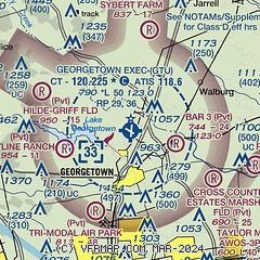
| Sectional chart |
|---|
|
CAUTION: Diagram may not be current

| Airport distance calculator |
|---|
|
|
| Sunrise and sunset |
|---|
|
Times for 13-Jul-2026
| | Local
(UTC-5) | | Zulu
(UTC) |
|---|
| Morning civil twilight | | 06:11 | | 11:11 |
| Sunrise | | 06:38 | | 11:38 |
| Sunset | | 20:35 | | 01:35 |
| Evening civil twilight | | 21:02 | | 02:02 |
|
| Current date and time |
|---|
| Zulu (UTC) | 13-Jul-2026 18:57:22 |
|---|
| Local (UTC-5) | 13-Jul-2026 13:57:22 |
|---|
|
| METAR |
|---|
| KGTU | 131755Z 00000KT 10SM CLR 32/22 A3011 RMK AO2 SLP190 T03170217 10328 20261 58010
|
KT74
14nm SE | 131835Z AUTO 22007KT 10SM SCT042 SCT049 33/22 A3013 RMK AO2 LTG DSNT N AND E
|
KEDC
18nm S | 131855Z AUTO VRB03KT 10SM CLR 32/22 A3009 RMK AO2 T03220217 $
|
KRYW
18nm SW | 131835Z AUTO 21004KT 10SM CLR 31/22 A3014 RMK AO2 LTG DSNT N AND NE T03090217
|
|
| TAF |
|---|
KAUS
24nm S | 131740Z 1318/1424 18006KT P6SM BKN040 BKN200 PROB30 1320/1322 VRB15G25KT 3SM TSRA BKN040CB FM132200 12006KT P6SM -SHRA VCTS BKN035CB PROB30 1322/1403 VRB15G25KT 3SM TSRA BKN030CB FM140600 18003KT P6SM SCT015 FM141300 20004KT P6SM -SHRA BKN030
|
KGRK
25nm N | 131735Z 1317/1422 VRB10G20KT 4800 -TSRA BKN020CB QNH3002INS BECMG 1323/1324 VRB06KT 8000 -SHRA BKN020 QNH3003INS TEMPO 1400/1403 VRB10G20KT 4800 TSRA BKN020CB BECMG 1411/1412 16010G20KT 1600 +TSRA OVC010CB QNH3005INS TX33/1321Z TN23/1412Z
|
|
| NOTAMs |
|---|
NOTAMs are issued by the DoD/FAA and will open in a separate window not controlled by AirNav.
|
|


