FAA INFORMATION EFFECTIVE 19 MARCH 2026
Location
| FAA Identifier: | HBR |
| Lat/Long: | 34-59-23.7000N 099-03-11.0110W
34-59.395000N 099-03.183517W
34.9899167,-99.0530586
(estimated) |
| Elevation: | 1563.2 ft. / 476.5 m (surveyed) |
| Variation: | 07E (2000) |
| From city: | 3 miles SE of HOBART, OK |
| Time zone: | UTC -5 (UTC -6 during Standard Time) |
| Zip code: | 73651 |
Airport Operations
| Airport use: | Open to the public |
| Activation date: | 03/1943 |
| Control tower: | no |
| ARTCC: | FORT WORTH CENTER |
| FSS: | MC ALESTER FLIGHT SERVICE STATION |
| NOTAMs facility: | HBR (NOTAM-D service available) |
| Attendance: | MON-FRI 0800-1600 |
| Wind indicator: | lighted |
| Segmented circle: | yes |
| Lights: | SS-SR |
| Beacon: | white-green (lighted land airport)
Operates sunset to sunrise. |
Airport Communications
| CTAF/UNICOM: | 122.8 |
| WX ASOS: | 133.325 (580-726-6651) |
| ALTUS APPROACH: | 125.1 |
| ALTUS DEPARTURE: | 125.1 |
- APCH/DEP CTL SVC PRVDD BY FORT WORTH ARTCC (ZFW) ON FREQS 128.4/269.375 (CLINTON-SHERMAN RCAG) WHEN ALTUS APCH CTL CLSD.
Nearby radio navigation aids
| VOR radial/distance | | VOR name | | Freq | | Var |
|---|
| HBRr354/7.4 | | HOBART VORTAC | | 115.85 | | 10E |
| BFVr148/16.6 | | BURNS FLAT VORTAC | | 110.00 | | 05E |
| LTSr024/22.4 | | ALTUS VORTAC | | 109.80 | | 05E |
Airport Services
| Fuel available: | 100LL JET-A+
100LL:FUEL AVBL 24 HR SELF SERVICE WITH MAJOR CREDIT CARD. |
| Parking: | tiedowns |
| Airframe service: | NONE |
| Powerplant service: | NONE |
| Bottled oxygen: | NONE |
| Bulk oxygen: | NONE |
Runway Information
Runway 17/35
| Dimensions: | 5507 x 100 ft. / 1679 x 30 m |
| Surface: | asphalt, in good condition |
| Weight bearing capacity: | |
| Runway edge lights: | medium intensity |
| RUNWAY 17 | | RUNWAY 35 |
| Latitude: | 34-59.931657N | | 34-59.023995N |
| Longitude: | 099-03.262873W | | 099-03.267323W |
| Elevation: | 1540.5 ft. | | 1561.2 ft. |
| Traffic pattern: | left | | left |
| Runway heading: | 173 magnetic, 180 true | | 353 magnetic, 360 true |
| Markings: | nonprecision, in good condition | | nonprecision, in good condition |
| Visual slope indicator: | 4-light PAPI on left (3.00 degrees glide path) | | 4-light PAPI on left (3.00 degrees glide path) |
| Touchdown point: | yes, no lights | | yes, no lights |
Runway 3/21
| Dimensions: | 2975 x 60 ft. / 907 x 18 m |
| Surface: | asphalt, in fair condition |
| Weight bearing capacity: | |
| Runway edge markings: | RWY 21 MARKINGS SVRLY FADED. |
| RUNWAY 3 | | RUNWAY 21 |
| Latitude: | 34-59.068833N | | 34-59.414667N |
| Longitude: | 099-03.244000W | | 099-02.821167W |
| Elevation: | 1560.8 ft. | | 1544.7 ft. |
| Traffic pattern: | left | | left |
| Runway heading: | 038 magnetic, 045 true | | 218 magnetic, 225 true |
| Markings: | basic, in poor condition | | basic, in poor condition |
| Touchdown point: | yes, no lights | | yes, no lights |
Airport Ownership and Management from official FAA records
| Ownership: | Publicly-owned |
| Owner: | CITY OF HOBART
PO BOX 231
HOBART, OK 73651
Phone 580-726-3100 |
| Manager: | KEVIN MAGRADY
22019 E 1396 RD
HOBART, OK 73651
Phone 580-726-2719 |
Additional Remarks
| - | FOR CD IF UNA TO CTC ON FSS FREQ, CTC FORT WORTH ARTCC AT 817-858-7584. |
Instrument Procedures
NOTE: All procedures below are presented as PDF files. If you need a reader for these files, you should download the free Adobe Reader.NOT FOR NAVIGATION. Please procure official charts for flight.
FAA instrument procedures published for use from 19 March 2026 at 0901Z to 16 April 2026 at 0900Z.
IAPs - Instrument Approach Procedures |
|---|
| RNAV (GPS) RWY 17 | |
download (251KB) |
| RNAV (GPS) RWY 35 | |
download (261KB) |
| VOR RWY 35 | |
download (239KB) |
| NOTE: Special Alternate Minimums apply | |
download (121KB) |
| NOTE: Special Take-Off Minimums/Departure Procedures apply | |
download (131KB) |
Other nearby airports with instrument procedures:
KLTS - Altus Air Force Base (22 nm SW)
KCSM - Clinton/Sherman Airport (22 nm N)
KAXS - Altus/Quartz Mountain Regional Airport (22 nm SW)
2K4 - Scott Field Airport (24 nm W)
KELK - Elk City Regional Business Airport (31 nm NW)
|
|

Road maps at:
MapQuest
Bing
Google
| Aerial photo |
|---|
WARNING: Photo may not be current or correct
 Photo taken 07-Aug-2015
looking north.
Photo taken 07-Aug-2015
looking north.
Do you have a better or more recent aerial photo of Hobart Regional Airport that you would like to share? If so, please send us your photo.
|
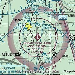
| Sectional chart |
|---|
|
| Airport distance calculator |
|---|
|
|
| Sunrise and sunset |
|---|
|
Times for 28-Mar-2026
| | Local
(UTC-5) | | Zulu
(UTC) |
|---|
| Morning civil twilight | | 07:04 | | 12:04 |
| Sunrise | | 07:30 | | 12:30 |
| Sunset | | 19:53 | | 00:53 |
| Evening civil twilight | | 20:18 | | 01:18 |
|
| Current date and time |
|---|
| Zulu (UTC) | 28-Mar-2026 05:36:14 |
|---|
| Local (UTC-5) | 28-Mar-2026 00:36:14 |
|---|
|
| METAR |
|---|
| KHBR | 280453Z AUTO 05012KT 10SM OVC080 12/M05 A3057 RMK AO2 SLP351 T01171050
|
|
| NOTAMs |
|---|
NOTAMs are issued by the DoD/FAA and will open in a separate window not controlled by AirNav.
|
|


