FAA INFORMATION EFFECTIVE 19 FEBRUARY 2026
Location
| FAA Identifier: | HCD |
| Lat/Long: | 44-51-35.6000N 094-22-57.0000W
44-51.593333N 094-22.950000W
44.8598889,-94.3825000
(estimated) |
| Elevation: | 1062.3 ft. / 323.8 m (surveyed) |
| Variation: | 04E (1995) |
| From city: | 2 miles S of HUTCHINSON, MN |
| Time zone: | UTC -6 (UTC -5 during Daylight Saving Time) |
| Zip code: | 55350 |
Airport Operations
| Airport use: | Open to the public |
| Activation date: | 09/1964 |
| Control tower: | no |
| ARTCC: | MINNEAPOLIS CENTER |
| FSS: | PRINCETON FLIGHT SERVICE STATION |
| NOTAMs facility: | HCD (NOTAM-D service available) |
| Attendance: | MON-FRI 0800-1700 |
| Wind indicator: | lighted |
| Segmented circle: | yes |
| Lights: | ACTVT OR INCR INTST REIL RWY 15 & 33; PAPI RWY 15 & 33; MIRL RWY 15/33 - CTAF. MIRL RWY 15/33 PRESET LOW INTST. |
| Beacon: | white-green (lighted land airport)
Operates sunset to sunrise. |
Airport Communications
| CTAF/UNICOM: | 122.8 |
| WX AWOS-3: | 118.525 (320-587-3343) |
| WX AWOS-3 at GYL (14 nm SE): | 119.625 (320-864-5830) |
| WX AWOS-3 at LJF (15 nm N): | 119.65 (320-693-6456) |
- APCH/DEP SVC PRVDD BY MINNEAPOLIS ARTCC ON FREQS 127.1/290.2 (REDWOOD FALLS RCAG).
Nearby radio navigation aids
| VOR radial/distance | | VOR name | | Freq | | Var |
|---|
| BDHr112/35.2 | | WILLMAR VOR/DME | | 113.70 | | 04E |
| RWFr046/39.6 | | REDWOOD FALLS VOR/DME | | 113.30 | | 07E |
Airport Services
| Fuel available: | 100LL JET-A
100LL:AVBL H24 VIA CREDIT CARD.
A:AVBL H24 VIA CREDIT CARD. |
| Parking: | hangars and tiedowns |
| Airframe service: | MAJOR |
| Powerplant service: | MAJOR |
| Bottled oxygen: | NONE |
| Bulk oxygen: | NONE |
Runway Information
Runway 15/33
| Dimensions: | 4000 x 75 ft. / 1219 x 23 m |
| Surface: | asphalt, in fair condition |
| Runway edge lights: | medium intensity |
| RUNWAY 15 | | RUNWAY 33 |
| Latitude: | 44-51.884550N | | 44-51.300812N |
| Longitude: | 094-23.164243W | | 094-22.736432W |
| Elevation: | 1054.7 ft. | | 1062.3 ft. |
| Traffic pattern: | left | | left |
| Runway heading: | 148 magnetic, 152 true | | 328 magnetic, 332 true |
| Markings: | nonprecision, in good condition | | nonprecision, in good condition |
| Visual slope indicator: | 4-light PAPI on left (3.00 degrees glide path) | | 4-light PAPI on left (3.00 degrees glide path) |
| Runway end identifier lights: | yes | | yes |
| Touchdown point: | yes, no lights | | yes, no lights |
| Obstructions: | 7 ft. crops, 276 ft. from runway, 137 ft. left of centerline, 10:1 slope to clear
RWY 15 HAS 7 FT CORN CROP 118 FT FM RWY END AND 163 FT R. | | 4 ft. crops, 234 ft. from runway, 152 ft. left of centerline, 8:1 slope to clear
RWY 33 HAS 7 FT CORN CROP 119 FT FM RWY END AND 194 FT R. |
Airport Ownership and Management from official FAA records
| Ownership: | Publicly-owned |
| Owner: | CITY OF HUTCHINSON
111 HASSAN ST SE
HUTCHINSON, MN 55350-2522
Phone 320-587-5151 |
| Manager: | DONOVAN SCHUETTE
1400 ADAMS ST SE
HUTCHINSON, MN 55350-7010
Phone 320-234-4473 |
Additional Remarks
| - | GCO AVBL ON FREQ 121.725 THRU MINNEAPOLIS ARTCC & FLT SVCS. |
| - | FOR CD IF UNA VIA GCO CTC MINNEAPOLIS ARTCC AT 651-463-5588. |
Instrument Procedures
NOTE: All procedures below are presented as PDF files. If you need a reader for these files, you should download the free Adobe Reader.NOT FOR NAVIGATION. Please procure official charts for flight.
FAA instrument procedures published for use from 19 February 2026 at 0901Z to 19 March 2026 at 0900Z.
IAPs - Instrument Approach Procedures |
|---|
| RNAV (GPS) RWY 15 | |
download (230KB) |
| RNAV (GPS) RWY 33 | |
download (193KB) |
| NOTE: Special Alternate Minimums apply | |
download (153KB) |
| NOTE: Special Take-Off Minimums/Departure Procedures apply | |
download (405KB) |
Other nearby airports with instrument procedures:
KGYL - Glencoe Municipal Airport (14 nm SE)
KLJF - Litchfield Municipal Airport (15 nm N)
KOVL - Olivia Regional Airport (28 nm W)
KMGG - Maple Lake Municipal Airport-Bill Mavencamp Sr Field (28 nm NE)
KCFE - Buffalo Municipal Airport (29 nm NE)
|
|

Road maps at:
MapQuest
Bing
Google
| Aerial photo |
|---|
WARNING: Photo may not be current or correct
 Photo by Shane Hjulberg
Photo taken 14-Aug-2011
looking north.
Photo by Shane Hjulberg
Photo taken 14-Aug-2011
looking north.
Do you have a better or more recent aerial photo of Hutchinson Municipal Airport-Butler Field that you would like to share? If so, please send us your photo.
|
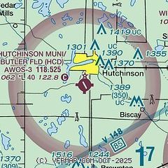
| Sectional chart |
|---|
|
| Airport distance calculator |
|---|
|
|
| Sunrise and sunset |
|---|
|
Times for 16-Mar-2026
| | Local
(UTC-5) | | Zulu
(UTC) |
|---|
| Morning civil twilight | | 07:00 | | 12:00 |
| Sunrise | | 07:29 | | 12:29 |
| Sunset | | 19:23 | | 00:23 |
| Evening civil twilight | | 19:53 | | 00:53 |
|
| Current date and time |
|---|
| Zulu (UTC) | 16-Mar-2026 08:42:25 |
|---|
| Local (UTC-5) | 16-Mar-2026 03:42:25 |
|---|
|
| METAR |
|---|
| KHCD | 160815Z AUTO 33018G24KT 10SM CLR M16/M20 A3007 RMK AO2 T11581204
|
KGYL
14nm SE | 160815Z AUTO 32015G23KT 10SM CLR M15/M20 A3005 RMK AO2 T11481196
|
KLJF
15nm N | 160815Z AUTO 33016G22KT 10SM CLR M17/M21 A3007 RMK AO2
|
|
| TAF |
|---|
KRWF
35nm SW | 160520Z 1606/1706 32020G33KT P6SM SCT250 FM161800 32018G26KT P6SM SCT025 FM170200 32010KT P6SM FEW250
|
KMKT
43nm SE | 160520Z 1606/1706 33024G32KT P6SM BKN100 FM160800 33022G33KT P6SM SCT150 FM161600 32020G28KT P6SM BKN035 FM170400 32011KT P6SM FEW250
|
KSTC
44nm N | 160520Z 1606/1706 34018G28KT P6SM FEW250 FM161100 33016G28KT P6SM SCT100 FM161700 34015G25KT P6SM SCT030 FM170300 33008KT P6SM FEW250
|
|
| NOTAMs |
|---|
NOTAMs are issued by the DoD/FAA and will open in a separate window not controlled by AirNav.
|
|

