FAA INFORMATION EFFECTIVE 16 APRIL 2026
Location
| FAA Identifier: | HCR |
| Lat/Long: | 40-28-54.5000N 111-25-43.7000W
40-28.908333N 111-25.728333W
40.4818056,-111.4288056
(estimated) |
| Elevation: | 5636.8 ft. / 1718.1 m (surveyed) |
| Variation: | 11E (2015) |
| From city: | 1 mile S of HEBER, UT |
| Time zone: | UTC -6 (UTC -7 during Standard Time) |
| Zip code: | 84032 |
Airport Operations
| Airport use: | Open to the public |
| Activation date: | 11/1947 |
| Control tower: | no |
| ARTCC: | SALT LAKE CITY CENTER |
| FSS: | CEDAR CITY FLIGHT SERVICE STATION |
| NOTAMs facility: | CDC (NOTAM-D service available) |
| Attendance: | MAY-OCT 0800-1830, NOV-APR 0800-1700 |
| Wind indicator: | lighted |
| Segmented circle: | yes |
| Lights: | ACTVT PAPI RWY 22; MIRL RWY 4/22 - CTAF. |
| Beacon: | white-green (lighted land airport)
Operates sunset to sunrise. |
| Landing fee: | yes, LNDG FEES: TSNT ACFT CTC AMGR. |
Airport Communications
| CTAF/UNICOM: | 122.8 |
| WX AWOS-3PT: | 124.825 (435-657-0892) |
- APCH/DEP CTL SVC PRVDD BY SALT LAKE CITY ARTCC ( ZLC) ON FREQS 119.95/377.15 (FRANCIS PEAK RCAG).
Nearby radio navigation aids
| VOR radial/distance | | VOR name | | Freq | | Var |
|---|
| PVUr025/20.9 | | PROVO VOR/DME | | 108.40 | | 15E |
| FFUr046/26.5 | | FAIRFIELD VORTAC | | 116.60 | | 16E |
| TCHr115/33.5 | | WASATCH VORTAC | | 116.80 | | 16E |
Airport Services
| Fuel available: | 100LL JET-A J |
| Parking: | hangars and tiedowns |
| Airframe service: | MAJOR |
| Powerplant service: | MAJOR |
| Bottled oxygen: | NONE |
| Bulk oxygen: | HIGH/LOW |
Runway Information
Runway 4/22
| Dimensions: | 6898 x 75 ft. / 2103 x 23 m |
| Surface: | asphalt, in excellent condition |
| Weight bearing capacity: | | PCN 32 /F/B/X/T | | Single wheel: | 30.0 |
|
| Runway edge lights: | medium intensity |
| RUNWAY 4 | | RUNWAY 22 |
| Latitude: | 40-28.541362N | | 40-29.274755N |
| Longitude: | 111-26.295962W | | 111-25.160452W |
| Elevation: | 5583.0 ft. | | 5636.8 ft. |
| Traffic pattern: | left | | left |
| Runway heading: | 039 magnetic, 050 true | | 219 magnetic, 230 true |
| Markings: | nonprecision, in good condition | | nonprecision, in good condition |
| Visual slope indicator: | | | 4-light PAPI on left (4.00 degrees glide path)
PAPI UNUSBL BYD 3.5 NM FM THLD AND BYD 6 DEGS LEFT AND RIGHT OF CNTRLN. |
| Touchdown point: | yes, no lights | | yes, no lights |
| Obstructions: | none | | 12 ft. road, 486 ft. from runway, 395 ft. right of centerline, 23:1 slope to clear |
Airport Ownership and Management from official FAA records
| Ownership: | Publicly-owned |
| Owner: | HEBER CITY
75 N. MAIN STREET
HEBER, UT 84032
Phone 435-654-0757 |
| Manager: | TRAVIS BIGGS
630 W AIRPORT RD., BOX 2
HEBER, UT 84032
Phone 435-657-7949 |
Additional Remarks
| - | ACFT DEPARTING SOUTH-SOUTHWESTBOUND BE AWARE OF HIGH TFC VOLUME DESCENDING TO 16,000 FT OVER SPANE INTERSECTION. |
| - | SMALL ACFT PRKG LCTD SOUTH WEST OF FUEL FARM. |
| - | RDO TMTN ON SFC MAY NOT BE RCVD AT OPPOSITE EOR. COMM INTFC FM TRRN INVOF APT, DEP ACFT MUST TMT START OF TAXI & DEPG RWY, PARL TWY HDG TO DEPG RWY, & LINE UP FOR DEP. |
| - | GLIDER ACTIVITY ON AND INVOF ARPT. |
| - | BALLOON ACTIVITY ON AND INVOF ARPT. |
| - | SNOW REMOVAL NOV-APR. |
| - | FOR CD CTC SALT LAKE ARTCC AT 801-320-2568. |
| - | PREFERRED CALM WIND RWY 22. |
| - | COLD TEMPERATURE AIRPORT. ALTITUDE CORRECTION REQUIRED AT OR BELOW -16C. |
| - | BIRDS ON & INVOF ARPT. |
| - | EXPC FBO FEE'S IE: FAC CHRGS, TIE DOWN FEES ETC. FEES ARE SEPERATE IN ADDN TO ARPT LNDG FEES. |
Instrument Procedures
NOTE: All procedures below are presented as PDF files. If you need a reader for these files, you should download the free Adobe Reader.NOT FOR NAVIGATION. Please procure official charts for flight.
FAA instrument procedures published for use from 16 April 2026 at 0901Z to 14 May 2026 at 0900Z.
IAPs - Instrument Approach Procedures |
|---|
| RNAV (GPS)-A | |
download (453KB) |
| NOTE: Special Alternate Minimums apply | |
download (38KB) |
Departure Procedures |
|---|
| COOLI SIX (RNAV) | |
download (129KB) |
| NOTE: Special Take-Off Minimums/Departure Procedures apply | |
download (272KB) |
Other nearby airports with instrument procedures:
KPVU - Provo Municipal Airport (21 nm SW)
KSPK - Spanish Fork Municipal Airport/Woodhouse Field (23 nm SW)
KSVR - South Valley Regional Airport (27 nm W)
KSLC - Salt Lake City International Airport (31 nm NW)
KTVY - Bolinder Field/Tooele Valley Airport (43 nm W)
|
|

Road maps at:
MapQuest
Bing
Google
| Aerial photo |
|---|
WARNING: Photo may not be current or correct
 Photo taken 27-Dec-2019
looking east.
Photo taken 27-Dec-2019
looking east.
Do you have a better or more recent aerial photo of Heber Valley Airport that you would like to share? If so, please send us your photo.
|
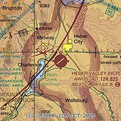
| Sectional chart |
|---|
|
CAUTION: Diagram may not be current

| Airport distance calculator |
|---|
|
|
| Sunrise and sunset |
|---|
|
Times for 22-Apr-2026
| | Local
(UTC-6) | | Zulu
(UTC) |
|---|
| Morning civil twilight | | 06:09 | | 12:09 |
| Sunrise | | 06:38 | | 12:38 |
| Sunset | | 20:11 | | 02:11 |
| Evening civil twilight | | 20:40 | | 02:40 |
|
| Current date and time |
|---|
| Zulu (UTC) | 22-Apr-2026 11:42:52 |
|---|
| Local (UTC-6) | 22-Apr-2026 05:42:52 |
|---|
|
| METAR |
|---|
| KHCR | 221115Z AUTO 22019G28KT 10SM CLR 13/M05 A2980 RMK AO2 PK WND 23032/1100 T01271052 $
|
|
| TAF |
|---|
| KHCR | 220520Z 2206/2306 20009KT P6SM FEW100 FM221600 22015G25KT P6SM FEW050 BKN070 FM230200 VRB06KT P6SM SCT040 BKN060
|
|
| NOTAMs |
|---|
NOTAMs are issued by the DoD/FAA and will open in a separate window not controlled by AirNav.
|
|


