FAA INFORMATION EFFECTIVE 09 JULY 2026
Location
| FAA Identifier: | HMY |
| Lat/Long: | 35-01-35.0200N 097-13-53.8600W
35-01.583667N 097-13.897667W
35.0263944,-97.2316278
(estimated) |
| Elevation: | 1091.3 ft. / 332.6 m (surveyed) |
| Variation: | 03E (2025) |
| From city: | 4 miles E of LEXINGTON, OK |
| Time zone: | UTC -5 (UTC -6 during Standard Time) |
| Zip code: | 73051 |
Heliport Operations
| Heliport use: | Private use. Permission required prior to landing |
| Activation date: | 12/1970 |
| Control tower: | no |
| ARTCC: | FORT WORTH CENTER |
| FSS: | MC ALESTER FLIGHT SERVICE STATION |
| NOTAMs facility: | MLC (NOTAM-D service available) |
| Attendance: | SEE REMARKS
TUES - THURS 1130-0500Z++; MON & FRI 1130-2230Z++; SLCT WKENDS 1300-2200Z++; OTR TIMES - C405-595-8844. |
| Wind indicator: | yes |
| Segmented circle: | no |
| Lights: | ACTVT LIRL RWY 17/35; PERIMETER LGTS; H1 & H2; TWY LGTS - C572-247-7303. |
| Beacon: | white-green-yellow (heliport)
ROTG BCN - 572-247-7303. |
Heliport Communications
| OKE CITY APPROACH: | 124.2 |
| OKE CITY DEPARTURE: | 124.2 |
| WX AWOS-3PT at OUN (18 nm NW): | 119.55 (405-325-7302) |
| WX AWOS-3 at PVJ (19 nm S): | 118.675 (405-238-4452) |
- MULDROW OPS (ADVSY SVS ONLY) - 139.425 227.200 46.90 (CTAF).
Nearby radio navigation aids
| VOR radial/distance | | VOR name | | Freq | | Var |
|---|
| IRWr130/27.2 | | WILL ROGERS VORTAC | | 114.10 | | 07E |
| PWAr138/36.6 | | WILEY POST VOR/DME | | 113.40 | | 08E |
Heliport Services
Runway Information
Runway 18/36
| Dimensions: | 2005 x 75 ft. / 611 x 23 m |
| Surface: | concrete, in fair condition |
| Runway edge lights: | low intensity |
| RUNWAY 18 | | RUNWAY 36 |
| Latitude: | 35-01.749000N | | 35-01.418500N |
| Longitude: | 097-13.894983W | | 097-13.900167W |
| Elevation: | 1091.3 ft. | | 1089.0 ft. |
| Traffic pattern: | left | | left |
| Markings: | basic, in fair condition | | basic, in fair condition |
| Touchdown point: | yes, no lights | | yes, no lights |
| Obstructions: | 15 ft. road, 100 ft. from runway | | 15 ft. road, 420 ft. from runway |
Helipad H1
| Dimensions: | 75 x 75 ft. / 23 x 23 m |
| Surface: | concrete, in fair condition |
| Runway edge lights: | PERI |
| Operational restrictions: | DSGND NORTHPAD. |
| Latitude: | 35-01.664167N | | |
| Longitude: | 097-13.949000W | | |
| Elevation: | 1091.0 ft. | | |
| Traffic pattern: | left | | left |
| Markings: | basic, in fair condition | | |
Helipad H2
| Dimensions: | 75 x 75 ft. / 23 x 23 m |
| Surface: | concrete, in fair condition |
| Runway edge lights: | PERI |
| Operational restrictions: | DSGND SOUTHPAD. |
| Latitude: | 35-01.525667N | | |
| Longitude: | 097-13.947667W | | |
| Elevation: | 1080.0 ft. | | |
| Traffic pattern: | left | | left |
| Markings: | basic, in fair condition | | |
Heliport Ownership and Management from official FAA records
| Ownership: | U.S. Army |
| Owner: | OKLAHOMA ARMY NATIONAL GUARD
HIGHWAY 39E & 144TH AVE
LEXINGTON, OK 73051
Phone 405-217-8101 |
| Manager: | CYRUS HAINES
HIGHWAY 39E & 144TH AVE
LEXINGTON, OK 73051
Phone 572-247-7378
572-247-7378. |
Additional Remarks
| A30A-18 | RWY 18 OVERRUN (FORMERLY 17) MEASURES 73 FT EAST TO WEST AND 75 FT NORTH TO SOUTH. |
| A30A-36 | RWY 36 OVERRUN (FORMERLY 35) MEASURES 73 FT EAST TO WEST AND 75 FT NORTH TO SOUTH. |
| - | CTN: HEL PRKG RAMP HAS PERIMETER FENCE. |
| - | RSTD: PPR FOR TSNT FUEL, PRK & NGT OPS - D628-8101/C572-247-7303. |
| - | SERVICE: FLUID - SP OIL. |
| - | SERVICE: JASU - 1, AGPU F. |
| - | FOR CD CTC OKC CITY APCH AT 405-681-5683. |
| - | TSNT FUEL, PRKG, AND NGT OPS FONE 572-247-7303. |
Instrument Procedures
NOTE: All procedures below are presented as PDF files. If you need a reader for these files, you should download the free Adobe Reader.NOT FOR NAVIGATION. Please procure official charts for flight.
FAA instrument procedures published for use from 09 July 2026 at 0901Z to 06 August 2026 at 0900Z.
IAPs - Instrument Approach Procedures |
|---|
| COPTER RNAV (GPS) RWY 18 | |
download (112KB) |
| COPTER RNAV (GPS) RWY 36 | |
download (117KB) |
| NOTE: Special Take-Off Minimums/Departure Procedures apply | |
download (403KB) |
Other nearby airports with instrument procedures:
1K4 - David Jay Perry Airport (14 nm NW)
KOUN - University of Oklahoma Westheimer Airport (18 nm NW)
KPVJ - Pauls Valley Municipal Airport (19 nm S)
KSNL - Shawnee Regional Airport (24 nm NE)
KTIK - Tinker Air Force Base (25 nm N)
|
|

Road maps at:
MapQuest
Bing
Google
| Aerial photo |
|---|

|
| Sectional chart |
|---|
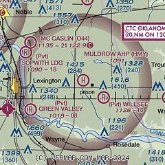
|
| Airport distance calculator |
|---|
|
|
| Sunrise and sunset |
|---|
|
Times for 27-Jul-2026
| | Local
(UTC-5) | | Zulu
(UTC) |
|---|
| Morning civil twilight | | 06:07 | | 11:07 |
| Sunrise | | 06:36 | | 11:36 |
| Sunset | | 20:35 | | 01:35 |
| Evening civil twilight | | 21:03 | | 02:03 |
|
| Current date and time |
|---|
| Zulu (UTC) | 27-Jul-2026 06:01:04 |
|---|
| Local (UTC-5) | 27-Jul-2026 01:01:04 |
|---|
|
| METAR |
|---|
KOUN
16nm NW | 270555Z AUTO 00000KT 10SM CLR 28/19 A2991 RMK AO2 T02800186 10369 20279
|
KPVJ
19nm S | 270555Z AUTO 00000KT 10SM CLR 26/19 A2997 RMK AO2 T02630192 10360 20263 TSNO
|
|
| TAF |
|---|
KOUN
16nm NW | 261720Z 2618/2718 19010G16KT P6SM SKC FM270000 17010KT P6SM SKC FM271500 22013G20KT P6SM SKC
|
|
| NOTAMs |
|---|
NOTAMs are issued by the DoD/FAA and will open in a separate window not controlled by AirNav.
|
|

