FAA INFORMATION EFFECTIVE 16 APRIL 2026
Location
| FAA Identifier: | HSP |
| Lat/Long: | 37-57-05.2300N 079-50-02.0000W
37-57.087167N 079-50.033333W
37.9514528,-79.8338889
(estimated) |
| Elevation: | 3792.4 ft. / 1155.9 m (surveyed) |
| Variation: | 08W (2000) |
| From city: | 3 miles S of HOT SPRINGS, VA |
| Time zone: | UTC -4 (UTC -5 during Standard Time) |
| Zip code: | 24460 |
Airport Operations
| Airport use: | Open to the public |
| Activation date: | 10/1937 |
| Control tower: | no |
| ARTCC: | WASHINGTON CENTER |
| FSS: | LEESBURG FLIGHT SERVICE STATION |
| NOTAMs facility: | HSP (NOTAM-D service available) |
| Attendance: | 0900-1700
ARNG CALL-OUT SVC DRNG BUS HRS. FEE FOR CALL-OUT SVC. |
| Wind indicator: | lighted |
| Segmented circle: | yes |
| Lights: | ACTVT REIL RWY 25, PAPI RWYS 07 & 25, HIRL RWY 07/25 & TWY LGTS - CTAF. |
| Beacon: | white-green (lighted land airport)
Operates sunset to sunrise. |
| Landing fee: | yes, LDG FEE (MULTI-ENGINE ACFT) WAIVED WITH FUEL PURCHASE. |
Airport Communications
| CTAF/UNICOM: | 123.0 |
| WX AWOS-3: | 118.8 (540-839-5974) |
- APCH/DEP SVC PRVDD BY WASHINGTON ARTCC ON FREQS 134.4/353.9 (BUENA VISTA RCAG).
Nearby radio navigation aids
| VOR radial/distance | | VOR name | | Freq | | Var |
|---|
| MOLr280/34.5 | | MONTEBELLO VOR/DME | | 115.30 | | 05W |
Airport Services
| Fuel available: | 100LL JET-A+ |
| Parking: | hangars and tiedowns |
| Airframe service: | NONE |
| Powerplant service: | NONE |
| Bottled oxygen: | NONE |
| Bulk oxygen: | NONE |
Runway Information
Runway 7/25
| Dimensions: | 5600 x 100 ft. / 1707 x 30 m |
| Surface: | asphalt/grooved, in fair condition |
| Weight bearing capacity: | | Single wheel: | 65.0 | | Double wheel: | 160.0 |
|
| Runway edge lights: | high intensity |
| RUNWAY 7 | | RUNWAY 25 |
| Latitude: | 37-56.848360N | | 37-57.325933N |
| Longitude: | 079-50.531683W | | 079-49.534922W |
| Elevation: | 3790.2 ft. | | 3762.9 ft. |
| Traffic pattern: | left | | left |
| Runway heading: | 067 magnetic, 059 true | | 247 magnetic, 239 true |
| Markings: | precision, in good condition | | precision, in good condition |
| Visual slope indicator: | 4-light PAPI on right (3.00 degrees glide path) | | 4-light PAPI on left (3.00 degrees glide path) |
| Runway end identifier lights: | | | yes |
| Touchdown point: | yes, no lights | | yes, no lights |
| Instrument approach: | | | ILS |
| Obstructions: | 27 ft. trees, 345 ft. from runway, 11 ft. right of centerline, 5:1 slope to clear | | none |
Airport Ownership and Management from official FAA records
| Ownership: | Publicly-owned |
| Owner: | BATH COUNTY ARPT AUTH
6240 AIRPORT ROAD
HOT SPRINGS, VA 24445
Phone 540-839-5326 |
| Manager: | PARKE KERSHNER
6240 AIRPORT ROAD
HOT SPRINGS, VA 24445
Phone 540-839-5326 |
Additional Remarks
| - | WILDLIFE, INCLUDING BEAR, ON & INVOF ARPT. |
| - | BE ADVISED LOW PASS TO CHECK/CLEAR WILDLIFE WHEN ARPT UNATNDD. |
| - | FOR CD CTC WASHINGTON ARTCC AT 703-771-3587. |
Instrument Procedures
NOTE: All procedures below are presented as PDF files. If you need a reader for these files, you should download the free Adobe Reader.NOT FOR NAVIGATION. Please procure official charts for flight.
FAA instrument procedures published for use from 16 April 2026 at 0901Z to 14 May 2026 at 0900Z.
IAPs - Instrument Approach Procedures |
|---|
| ILS OR LOC RWY 25 | |
download (210KB) |
| RNAV (GPS) RWY 07 | |
download (199KB) |
| RNAV (GPS) RWY 25 | |
download (219KB) |
| NOTE: Special Alternate Minimums apply | |
download (144KB) |
| NOTE: Special Take-Off Minimums/Departure Procedures apply | |
download (357KB) |
Other nearby airports with instrument procedures:
KLWB - Greenbrier Valley Airport (27 nm W)
KROA - Roanoke-Blacksburg Regional Airport/Woodrum Field (38 nm S)
W13 - Eagle's Nest Airport (43 nm E)
W90 - New London Airport (47 nm SE)
KSHD - Shenandoah Valley Regional Airport (48 nm NE)
|
|

Road maps at:
MapQuest
Bing
Google
| Aerial photo |
|---|
WARNING: Photo may not be current or correct
 Photo taken 05-Dec-2019
looking north.
Photo taken 05-Dec-2019
looking north.
Do you have a better or more recent aerial photo of Ingalls Field Airport that you would like to share? If so, please send us your photo.
|
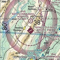
| Sectional chart |
|---|
|
| Airport distance calculator |
|---|
|
|
| Sunrise and sunset |
|---|
|
Times for 25-Apr-2026
| | Local
(UTC-4) | | Zulu
(UTC) |
|---|
| Morning civil twilight | | 06:04 | | 10:04 |
| Sunrise | | 06:32 | | 10:32 |
| Sunset | | 20:03 | | 00:03 |
| Evening civil twilight | | 20:31 | | 00:31 |
|
| Current date and time |
|---|
| Zulu (UTC) | 25-Apr-2026 14:18:17 |
|---|
| Local (UTC-4) | 25-Apr-2026 10:18:17 |
|---|
|
| METAR |
|---|
| KHSP | 251355Z AUTO 27008KT 10SM CLR 17/10 A2991 RMK AO2 T01690097
|
|
| TAF |
|---|
KLWB
27nm W | 251131Z 2512/2612 04003KT P6SM SKC FM251900 25006KT P6SM -SHRA VCTS BKN035CB FM252300 VRB03KT 6SM -SHRA BR BKN035 FM260500 31001KT 1SM BR BKN025 FM260700 32002KT 1/4SM FG OVC015
|
|
| NOTAMs |
|---|
NOTAMs are issued by the DoD/FAA and will open in a separate window not controlled by AirNav.
|
|

