FAA INFORMATION EFFECTIVE 25 DECEMBER 2025
Location
| FAA Identifier: | HWY |
| Lat/Long: | 38-35-10.6270N 077-42-38.2710W
38-35.177117N 077-42.637850W
38.5862853,-77.7106308
(estimated) |
| Elevation: | 336.2 ft. / 102.5 m (surveyed) |
| Variation: | 10W (2005) |
| From city: | 12 miles SE of WARRENTON, VA |
| Time zone: | UTC -5 (UTC -4 during Daylight Saving Time) |
| Zip code: | 22728 |
Airport Operations
| Airport use: | Open to the public |
| Activation date: | 06/1964 |
| Control tower: | no |
| ARTCC: | WASHINGTON CENTER |
| FSS: | LEESBURG FLIGHT SERVICE STATION |
| NOTAMs facility: | DCA (NOTAM-D service available) |
| Attendance: | 0800-DARK |
| Wind indicator: | lighted |
| Segmented circle: | yes |
| Lights: | ACTVT HIRL RWY 15/33 - CTAF. |
| Beacon: | white-green (lighted land airport)
Operates sunset to sunrise. |
Airport Communications
| CTAF/UNICOM: | 122.7 |
| WX AWOS-3: | 120.350 (540-788-4078) |
| POTOMAC APPROACH: | 128.525 |
| POTOMAC DEPARTURE: | 128.525 |
| HYPER STAR: | 133.0 |
| TIKEE STAR: | 120.45 |
| TRSTN STAR: | 126.75 |
| WX AWOS-3 at CJR (8 nm SW): | 119.325 (540-727-0523) |
| WX AWOS-3PT at HEF (12 nm NE): | PHONE 703-361-6160 |
| WX AWOS-3 at RMN (16 nm SE): | 126.325 (540-657-8283) |
Nearby radio navigation aids
| VOR radial/distance | | VOR name | | Freq | | Var |
|---|
| CSNr120/8.0 | | CASANOVA VORTAC | | 116.30 | | 06W |
| BRVr321/22.5 | | BROOKE VORTAC | | 114.50 | | 09W |
| AMLr217/23.8 | | ARMEL VOR/DME | | 113.50 | | 08W |
| LDNr131/28.2 | | LINDEN VORTAC | | 114.30 | | 06W |
| DCAr252/35.6 | | WASHINGTON VOR/DME | | 111.00 | | 09W |
| NDB name | | Hdg/Dist | | Freq | | Var | | ID |
|---|
| NAILR | | 059/12.1 | | 351 | | 10W | | MSQ | -- ... --.- |
| SHANNON | | 338/22.8 | | 237 | | 10W | | EZF | . --.. ..-. |
| OXONN | | 262/33.8 | | 332 | | 11W | | VQK | ...- --.- -.- |
| GEORGETOWN | | 242/34.3 | | 323 | | 09W | | GTN | --. - -. |
| CAVERNS | | 110/36.3 | | 245 | | 09W | | LUA | .-.. ..- .- |
Airport Services
| Fuel available: | 100LL JET-A |
| Parking: | hangars and tiedowns |
| Airframe service: | MAJOR |
| Powerplant service: | MAJOR |
| Bottled oxygen: | NONE |
| Bulk oxygen: | NONE |
Runway Information
Runway 15/33
| Dimensions: | 5000 x 100 ft. / 1524 x 30 m |
| Surface: | asphalt/grooved, in fair condition |
| Weight bearing capacity: | | Single wheel: | 15.0 | | Double wheel: | 70.0 |
|
| Runway edge lights: | high intensity |
| RUNWAY 15 | | RUNWAY 33 |
| Latitude: | 38-35.487063N | | 38-34.867155N |
| Longitude: | 077-42.983353W | | 077-42.292412W |
| Elevation: | 313.2 ft. | | 336.2 ft. |
| Traffic pattern: | left | | left |
| Runway heading: | 149 magnetic, 139 true | | 329 magnetic, 319 true |
| Markings: | nonprecision, in fair condition | | nonprecision, in fair condition |
| Visual slope indicator: | 4-light PAPI on left (3.00 degrees glide path) | | 4-light PAPI on left (3.00 degrees glide path) |
| Runway end identifier lights: | yes | | yes |
| Touchdown point: | yes, no lights | | yes, no lights |
| Instrument approach: | LOC/DME | | |
| Obstructions: | 87 ft. tree, 2398 ft. from runway, 756 ft. right of centerline, 25:1 slope to clear | | 92 ft. tree, 3187 ft. from runway, 268 ft. left of centerline, 32:1 slope to clear |
Airport Ownership and Management from official FAA records
| Ownership: | Publicly-owned |
| Owner: | FAUQUIER COUNTY
10 HOTEL ST, SUITE 204
WARRENTON, VA 20186
Phone 540-422-8283 |
| Manager: | CHRIS BUTLER
1533 IRIS TRAIL, PO BOX 198
MIDLAND, VA 22728-0068
Phone 540-422-8283 |
Additional Remarks
| - | ULTRALIGHT ACTIVITY ON & INVOF ARPT. |
| - | FOR CD CTC POTOMAC APCH AT 866-709-4993. |
| - | NOISE ABATEMENT PROCS IN EFCT OVER TOWN OF MIDLAND; CTC AMGR 540-422-8283. |
| - | RWY 15 PREF CALM WIND RWY. |
| - | AEROBATIC ACTIVITY ADJACENT TO WEST SIDE OF RWY 15/33. |
| - | AEROBATIC DEMO AREA WITHIN 2 NM SOUTH OF ARPT 3500 FT & BLW; 1000-2200; MAY - OCT. |
Instrument Procedures
NOTE: All procedures below are presented as PDF files. If you need a reader for these files, you should download the free Adobe Reader.NOT FOR NAVIGATION. Please procure official charts for flight.
FAA instrument procedures published for use from 25 December 2025 at 0901z to 22 January 2026 at 0900z.
STARs - Standard Terminal Arrivals |
|---|
| HYPER NINE (RNAV) | |
2 pages:
[1] [2] (381KB) |
| HYPER NINE (RNAV), CONT.2 | |
download (164KB) |
| TIKEE FOUR (RNAV) | |
download (215KB) |
| TRSTN FOUR (RNAV) | |
2 pages:
[1] [2] (317KB) |
IAPs - Instrument Approach Procedures |
|---|
| LOC/DME RWY 15 | |
download (251KB) |
| RNAV (GPS) RWY 15 | |
download (255KB) |
| RNAV (GPS) RWY 33 | |
download (233KB) |
| VOR RWY 15 | |
download (248KB) |
| NOTE: Special Alternate Minimums apply | |
download (143KB) |
| NOTE: Special Take-Off Minimums/Departure Procedures apply | |
download (357KB) |
Other nearby airports with instrument procedures:
KCJR - Culpeper Regional Airport (8 nm SW)
KHEF - Manassas Regional Airport/Harry P. Davis Field (12 nm NE)
KRMN - Stafford Regional Airport (16 nm SE)
KNYG - Quantico Marine Corps Air Facility (Turner Field) (20 nm E)
KEZF - Shannon Airport (23 nm SE)
|
|

Road maps at:
MapQuest
Bing
Google
| Aerial photo |
|---|
WARNING: Photo may not be current or correct
 Photo by Ken Peppard
Photo taken 02-Jun-2023
looking southeast.
Photo by Ken Peppard
Photo taken 02-Jun-2023
looking southeast.
Do you have a better or more recent aerial photo of Warrenton/Fauquier Airport that you would like to share? If so, please send us your photo.
|
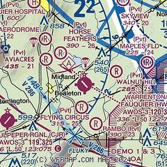
| Sectional chart |
|---|
|
CAUTION: Diagram may not be current

| Airport distance calculator |
|---|
|
|
| Sunrise and sunset |
|---|
|
Times for 18-Jan-2026
| | Local
(UTC-5) | | Zulu
(UTC) |
|---|
| Morning civil twilight | | 06:58 | | 11:58 |
| Sunrise | | 07:27 | | 12:27 |
| Sunset | | 17:16 | | 22:16 |
| Evening civil twilight | | 17:45 | | 22:45 |
|
| Current date and time |
|---|
| Zulu (UTC) | 19-Jan-2026 01:51:30 |
|---|
| Local (UTC-5) | 18-Jan-2026 20:51:30 |
|---|
|
| METAR |
|---|
| KHWY | 190135Z AUTO 34003KT 10SM CLR M05/M10 A2997 RMK AO2 T10541105
|
KCJR
8nm SW | 190135Z AUTO 00000KT 10SM CLR M05/M09 A2998 RMK AO2 T10501094
|
KHEF
12nm NE | 190056Z 34008KT 10SM CLR M02/M08 A2996 RMK AO2 SLP151 T10221083 $
|
KRMN
16nm SE | 190115Z AUTO 34003KT 10SM SCT075 M01/M07 A2994 RMK AO2 T10101066
|
|
| TAF |
|---|
KIAD
24nm NE | 182213Z 1822/1924 36008KT 6SM -SN BKN045 OVC060 FM190000 32010KT P6SM OVC050 FM190600 29003KT P6SM FEW250 FM191000 21007KT P6SM SKC FM191800 26013G23KT P6SM FEW050
|
|
| NOTAMs |
|---|
NOTAMs are issued by the DoD/FAA and will open in a separate window not controlled by AirNav.
|
|


