FAA INFORMATION EFFECTIVE 16 APRIL 2026
Location
| FAA Identifier: | NYG |
| Lat/Long: | 38-30-13.0482N 077-18-18.1221W
38-30.217470N 077-18.302035W
38.5036245,-77.3050339
(estimated) |
| Elevation: | 10.3 ft. / 3.1 m (surveyed) |
| Variation: | 11W (2025) |
| From city: | 1 mile S of QUANTICO, VA |
| Time zone: | UTC -4 (UTC -5 during Standard Time) |
| Zip code: | 22134 |
Airport Operations
| Airport use: | Private use. Permission required prior to landing |
| Activation date: | 01/1944 |
| Control tower: | yes |
| ARTCC: | WASHINGTON CENTER |
| FSS: | LEESBURG FLIGHT SERVICE STATION |
| NOTAMs facility: | DCA (NOTAM-D service available) |
| Attendance: | MON-THU 1300-0000Z++, ALL FRI 1300-2200Z++, ALL/SAT/SUN/HOLS/CLSD |
| Segmented circle: | no |
| Lights: | WHEN TWR CLSD ACTVT REILS RWY 02 & 20; PAPI RWY 02; HIRL RWY 02/20; CL RWY 02; TWY LGTS - CTAF. TO ACTVT & INCR INTS CMSND KEY 118.6 7 TIMES HIGH, 5 TIMES MED, 3 TIMES LOW. |
| Beacon: | white-white-green (lighted military airport)
Operates sunset to sunrise. |
Airport Communications
| CTAF: | 118.6 |
| ATIS: | 263.15 |
| QUANTICO GROUND: | 121.75 340.2 [1300-0200Z++ MON-THU; 1300-2200Z++ FRI; OPR SAT, SUN, AND HOL BY NOTAM ONLY.] |
| QUANTICO TOWER: | 118.6 360.2 [1300-0200Z++ MON-THU; 1300-2200Z++ FRI; OPR SAT, SUN, AND HOL BY NOTAM ONLY.] |
| POTOMAC APPROACH: | 127.05 290.375 128.525 ;WHEN NYG TWR CLSD |
| POTOMAC DEPARTURE: | 127.05 290.375 128.525 ;WHEN NYG TWR CLSD |
| BASE OPS: | 355.3 |
| EMERG: | 121.5 243.0 |
| HYPER STAR: | 133.0 |
| PMSV METRO: | 355.3 |
| TIKEE STAR: | 120.45 |
| TRSTN STAR: | 126.75 |
| WX AWOS-3 at RMN (9 nm SW): | 126.325 (540-657-8283) |
| WX AWOS-3 at EZF (16 nm SW): | 128.125 (540-372-6794) |
| WX AWOS-3PT at HEF (16 nm NW): | PHONE 703-361-6160 |
| WX AWOS-3 at HWY (20 nm W): | 120.350 (540-788-4078) |
- 1300-0000Z++ MON-THU; 1300-2200Z++ FRI; OPR SAT, SUN, AND HOL BY NOTAM ONLY.
Nearby radio navigation aids
| VOR radial/distance | | VOR name | | Freq | | Var |
|---|
| BRVr022/10.3 | | BROOKE VORTAC | | 114.50 | | 09W |
| DCAr220/24.8 | | WASHINGTON VOR/DME | | 111.00 | | 09W |
| AMLr172/26.9 | | ARMEL VOR/DME | | 113.50 | | 08W |
| ADWr238/27.5 | | ANDREWS VORTAC | | 113.10 | | 10W |
| CSNr113/27.6 | | CASANOVA VORTAC | | 116.30 | | 06W |
| NDB name | | Hdg/Dist | | Freq | | Var | | ID |
|---|
| SHANNON | | 036/15.8 | | 237 | | 10W | | EZF | . --.. ..-. |
| OXONN | | 231/20.4 | | 332 | | 11W | | VQK | ...- --.- -.- |
| GEORGETOWN | | 207/26.9 | | 323 | | 09W | | GTN | --. - -. |
| NAILR | | 094/28.3 | | 351 | | 10W | | MSQ | -- ... --.- |
Airport Services
| Fuel available: | A1+ |
| Bottled oxygen: | NONE |
| Bulk oxygen: | HIGH |
Runway Information
Runway 2/20
| Dimensions: | 4250 x 184 ft. / 1295 x 56 m |
| Surface: | PEM/grooved
RWY 02/20 GROOVED FULL LENGTH. |
| Weight bearing capacity: | |
| Runway edge lights: | high intensity |
| RUNWAY 2 | | RUNWAY 20 |
| Latitude: | 38-29.878665N | | 38-30.556297N |
| Longitude: | 077-18.414253W | | 077-18.189673W |
| Elevation: | 9.4 ft. | | 10.3 ft. |
| Traffic pattern: | left | | left |
| Runway heading: | 026 magnetic, 015 true | | 206 magnetic, 195 true |
| Markings: | precision, in fair condition | | precision, in fair condition |
| Visual slope indicator: | 4-light PAPI on left (3.00 degrees glide path) | | |
| Runway end identifier lights: | yes | | yes |
| Centerline lights: | yes
FIRST 1000 FT. | | no |
| Touchdown point: | yes, no lights | | yes, no lights |
| Instrument approach: | ILS/DME | | |
Airport Ownership and Management from official FAA records
| Ownership: | U.S. Navy |
| Owner: | US NAVY
OCEANOGRAPHIC OFC-CODE 3142
WASHINGTON, DC 20373 |
| Manager: | COMMANDING OFFICER
MARINE CORPS AIR STATION
QUANTICO, VA 22134
Phone 703-784-2084
ARPT MANAGER 703-784-1449. |
Additional Remarks
| - | FUEL: A++; LTD SUP. EXP NO MORE THAN 10K OVER PPR. |
| - | TRAN ALERT: NO TRAN MAINT AVBL. REQUIRE QUALIFIED CREW MEMBER TO ASSIST IN COLD REFUELING. |
| - | BIRD HAZ VCNTY RWY 02-20 SR-SS. HVY MIGRATORY BIRD ACT OCT-MAR, HVY OSPREY ACT MAR-JUL, HVY EAGLE ACT DEC-JUL. |
| - | NS ABTMT: THE AREA IN AND ARND THE QUANTICO CLASS D AIRSPACE IS NOISE SENSITIVE. COPTER TRANSIT QUANTICO CLASS D AIRSPACE AT OR ABV 1000 FT AGL. |
| - | MISC: CAT II CRASH/FIRE RESCUE SVC. |
| - | REMARKS: MCAF QUANTICO HAS NO PROVISIONS FOR SPACE A PASSENGERS. SPACE A PASSENGERS CANNOT BE ON-LOADED OR OFF-LOADED DUE TO SECURITY ISSUES. |
| - | MISC: MCAF QUANTICO AND R-6608 LIE WITH THE WASHINGTON ADIZ. PILOTS MUST ADHERE TO ADIZ RPRTG PROCS IN BOTH THESE AREAS. TWY A LTD TO R/W DALGT VFR ONLY. |
| - | CSTMS/AG/IMG: NOT AVBL. |
| - | RSTD: ALL TRAN ACFT 24 HR PPR; BASE OPS DSN 278-2085/1459, OR C703-784-2085/1459. AFTER 2200Z++ AND ON WEEKEND CALL DSN 378-0920, C703-432-0920 OR C703-675-3623 FOR PPR. NO TRAN ACFT OPS OUTSIDE PUBL HR WO MCAF QUANTICO CO APVL. |
| - | CAUTION: NO MANDATORY RWY VFR HOLD POSITION SIGNS CO-LOCATED W/MARKINGS ON TWYS A, B, AND D. RWY 02 OVRN 100 FT. RWY 20 NO OVRN. |
| - | FOR CD WHEN NYG ATCT/APCH ARE CLSD CTC POTOMAC APCH AT 866-709-4993. |
| - | RWY: NO 180 DEG TURNS ON RWY ASP. |
| - | MISC: 180 DEG TURNS ONLY ON CONC EOR. |
| - | MISC: NO STAGGERED ACFT DEVS FR RCL. |
| - | CAUTION: TWY D SFC CONSISTS OF AM-2 ALUMINUM MATTING WITH NON-SKID ALL WX COATING; NO EDGE LGTNG ON TWY D. TWY B EDGE LGT NON STD FIRST 100 FT AT RWY ENTERANCE/EXIT (NORTH EDGE) LOCATED 20 FT FROM USABLE PAVEMENT. |
| - | C-17 LANDING ZONE MARKED BUT NOT CERTIFIED. ASSAULT LDGS NA. |
| - | MISC: AUTOMATED WEATHER BROADCAST AVBL DURING HOUR OF AIRFIELD CLOSURE ON 355.3. |
Instrument Procedures
NOTE: All procedures below are presented as PDF files. If you need a reader for these files, you should download the free Adobe Reader.NOT FOR NAVIGATION. Please procure official charts for flight.
FAA instrument procedures published for use from 16 April 2026 at 0901Z to 14 May 2026 at 0900Z.
STARs - Standard Terminal Arrivals |
|---|
| HYPER NINE (RNAV) | |
2 pages:
[1] [2] (383KB) |
| HYPER NINE (RNAV), CONT.2 | |
download (165KB) |
| PRIVO THREE | |
2 pages:
[1] [2] (266KB) |
| TIKEE FOUR (RNAV) | |
download (216KB) |
IAPs - Instrument Approach Procedures |
|---|
| ILS OR LOC/DME RWY 02 | |
download (145KB) |
| RNAV (GPS) RWY 02 | |
download (84KB) |
| TACAN RWY 02 | |
download (128KB) |
| Radar Approach Procedures available | |
download (140KB) |
| NOTE: Special Take-Off Minimums/Departure Procedures apply | |
download (364KB) |
Other nearby airports with instrument procedures:
KRMN - Washington Executive/Stafford Regional Airport (9 nm SW)
2W5 - Maryland Airport (12 nm NE)
KDAA - Davison Army Airfield (14 nm NE)
KEZF - Shannon Airport (16 nm SW)
KHEF - Manassas Regional Airport/Harry P. Davis Field (16 nm NW)
KHWY - Warrenton/Fauquier Airport (20 nm W)
|
|

Road maps at:
MapQuest
Bing
Google
| Aerial photo |
|---|
WARNING: Photo may not be current or correct
 Jeff Long, SkyFocal.com
Photo taken 06-Jan-2012
looking north.
Jeff Long, SkyFocal.com
Photo taken 06-Jan-2012
looking north.
Do you have a better or more recent aerial photo of Quantico Marine Corps Air Facility (Turner Field) that you would like to share? If so, please send us your photo.
|
| Sectional chart |
|---|
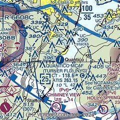
|
| Airport distance calculator |
|---|
|
|
| Sunrise and sunset |
|---|
|
Times for 06-May-2026
| | Local
(UTC-4) | | Zulu
(UTC) |
|---|
| Morning civil twilight | | 05:38 | | 09:38 |
| Sunrise | | 06:07 | | 10:07 |
| Sunset | | 20:04 | | 00:04 |
| Evening civil twilight | | 20:33 | | 00:33 |
|
| Current date and time |
|---|
| Zulu (UTC) | 07-May-2026 02:11:45 |
|---|
| Local (UTC-4) | 06-May-2026 22:11:45 |
|---|
|
| METAR |
|---|
| KNYG | 070156Z AUTO 17003KT 8SM FEW039 FEW050 BKN070 19/17 A2981 RMK AO2 SLP094 T01890172
|
KRMN
9nm SW | 070155Z AUTO 00000KT 10SM SCT050 BKN065 19/16 A2980 RMK AO2 T01880156
|
KDAA
14nm NE | 070155Z AUTO 00000KT 10SM BKN031 19/17 A2977 RMK AO2 SLP084 T01870168 $
|
KEZF
16nm SW | 070155Z AUTO 20003KT 10SM SCT060 20/16 A2979 RMK AO2 T01960160
|
KHEF
16nm NW | 070156Z 33007KT 10SM -RA FEW017 OVC024 18/16 A2981 RMK AO2 RAB18 SLP099 P0000 T01830156 $
|
KHWY
20nm W | 070155Z AUTO 04004KT 10SM 19/17 A2980 RMK AO2 T01930171
|
|
| TAF |
|---|
| KNYG | 062100Z 0621/0721 20010G20KT 9999 SCT090 OVC130 QNH2973INS BECMG 0706/0708 33009KT 9999 BKN009 OVC016 QNH2983INS FM070900 35009KT 9999 BKN040 OVC060 QNH2985INS BECMG 0715/0717 01009KT 9999 BKN065 OVC090 QNH2988INS LAST NO AMDS AFT 0621 NEXT 0709 AUTOMATED SENSOR METWATCH 0623 TIL 0712 TX24/0621Z TN13/0713Z
|
KDAA
14nm NE | 062000Z 0620/0802 18009KT 9999 SCT020 BKN070 QNH2974INS TEMPO 0622/0701 VRB15G25KT 4800 -TSRA OVC020CB BECMG 0700/0701 34010KT 9000 -SHRA BKN020 OVC030 QNH2978INS BECMG 0703/0704 35012G18KT 9000 -SHRA BKN025 OVC040 QNH2982INS BECMG 0712/0713 35012G18KT 9999 NSW OVC050 QNH2986INS BECMG 0717/0718 01010G15KT 9999 SCT070 QNH2978INS TX22/0622Z TN12/0710Z LAST NO AMDS AFT 0701 NEXT 0712
|
|
| NOTAMs |
|---|
NOTAMs are issued by the DoD/FAA and will open in a separate window not controlled by AirNav.
|
|

