FAA INFORMATION EFFECTIVE 11 JUNE 2026
Location
| FAA Identifier: | IAD |
| Lat/Long: | 38-56-50.8430N 077-27-35.7430W
38-56.847383N 077-27.595717W
38.9474564,-77.4599286
(estimated) |
| Elevation: | 312.3 ft. / 95.2 m (surveyed) |
| Variation: | 10W (2000) |
| From city: | 20 miles W of WASHINGTON, DC |
| Time zone: | UTC -4 (UTC -5 during Standard Time) |
| Zip code: | 20166 |
Airport Operations
| Airport use: | Open to the public |
| Activation date: | 11/1962 |
| Control tower: | yes |
| ARTCC: | WASHINGTON CENTER |
| FSS: | LEESBURG FLIGHT SERVICE STATION |
| NOTAMs facility: | IAD (NOTAM-D service available) |
| Attendance: | CONTINUOUS |
| Wind indicator: | lighted |
| Segmented circle: | no |
| Beacon: | white-green (lighted land airport)
Operates sunset to sunrise. |
| Landing fee: | yes |
| Fire and rescue: | ARFF index E |
| International operations: | customs landing rights airport |
Airport Communications
| UNICOM: | 122.95 |
| WX ASOS: | 134.85 (571-250-7817) |
| DULLES GROUND: | 121.625 ;WEST 121.9 ;EAST 317.8 ;EAST 348.6 ;WEST |
| DULLES TOWER: | 120.1 ;RWY 01R/19L 120.25 ;RWY 01C/19C 134.425 ;RWY 01L/19R, RWY 12/30 317.8 ;RWY 01R/19L 348.6 ;RWY 01C/19C 348.6 ;RWY 01L/19R, RWY 12/30 |
| POTOMAC APPROACH: | 120.45 ;241-330 126.1 ;331-090 128.525 ;091-240 |
| POTOMAC DEPARTURE: | 125.05 ;300-010 126.65 ;190-300 |
| CLEARANCE DELIVERY: | 135.7 317.8 |
| BUNZZ DP: | 126.65 |
| CAPITAL DP: | 125.05 ;POTOMAC DEP CON NORTH 126.65 ;POTOMAC DEP CON SOUTH |
| CAVLR STAR: | 128.525 |
| CLASS B: | 120.45 ;241-330 126.1 ;331-090 128.525 ;091-240 |
| CLTCH DP: | 126.65 |
| COATT STAR: | 128.525 |
| D-ATIS: | 134.85 |
| DELRO STAR: | 133.0 |
| EMERG: | 121.5 243.0 |
| GIBBZ STAR: | 120.45 |
| HYPER STAR: | 133.0 |
| JCOBY DP: | 125.05 |
| JDUBB DP: | 126.65 |
| JERES DP: | 125.05 |
| MCRAY DP: | 125.05 |
| PRIVO STAR: | 133.0 |
| RAMP CTL: | 129.55 ;MIDFLD |
| RNLDI DP: | 126.65 |
| SCRAM DP: | 126.65 |
| SELINSGROVE STAR: | 133.0 |
| WIGOL STAR: | 132.85 |
| WOOLY DP: | 125.05 |
| WX AWOS-3 at JYO (9 nm NW): | 125.225 (703-777-3781) |
| WX AWOS-3PT at HEF (14 nm S): | PHONE 703-361-6160 |
| WX AWOS-3PT at GAI (19 nm NE): | 128.275 (301-977-2971) |
- ASR RADAR UNAVBL ABV 15000 FT.
- ASDE-X IN USE. OPERATE TRANSPONDERS WITH ALTITUDE REPORTING MODE AND ADS-B (IF EQUIPPED) ENABLED ON ALL AIRPORT SURFACES.
- ARRIVALS MAY BE EXTENDED OUTSIDE OF CLASS B.
Nearby radio navigation aids
| VOR radial/distance | | VOR name | | Freq | | Var |
|---|
| AML at field | | ARMEL VOR/DME | | 113.50 | | 08W |
| DCAr294/20.5 | | WASHINGTON VOR/DME | | 111.00 | | 09W |
| CSNr052/26.4 | | CASANOVA VORTAC | | 116.30 | | 06W |
| FDKr196/28.2 | | FREDERICK VOR/DME | | 116.85 | | 08W |
| ADWr297/29.0 | | ANDREWS VORTAC | | 113.10 | | 10W |
| MRBr152/31.9 | | MARTINSBURG VORTAC | | 112.10 | | 07W |
| LDNr087/35.3 | | LINDEN VORTAC | | 114.30 | | 06W |
| BRVr001/37.0 | | BROOKE VORTAC | | 114.50 | | 09W |
| BALr261/39.6 | | BALTIMORE VORTAC | | 115.10 | | 11W |
| EMIr222/39.7 | | WESTMINSTER VORTAC | | 117.90 | | 08W |
| NDB name | | Hdg/Dist | | Freq | | Var | | ID |
|---|
| GEORGETOWN | | 283/15.7 | | 323 | | 09W | | GTN | --. - -. |
| OXONN | | 309/23.0 | | 332 | | 11W | | VQK | ...- --.- -.- |
| NAILR | | 045/36.2 | | 351 | | 10W | | MSQ | -- ... --.- |
| ELLICOTT | | 248/37.8 | | 371 | | 11W | | FND | ..-. -. -.. |
Airport Services
| Fuel available: | 100LL JET-A |
| Parking: | hangars and tiedowns |
| Airframe service: | MAJOR |
| Powerplant service: | MAJOR |
| Bottled oxygen: | HIGH |
| Bulk oxygen: | HIGH |
Runway Information
Runway 1C/19C
| Dimensions: | 11500 x 150 ft. / 3505 x 46 m |
| Surface: | concrete/grooved, in excellent condition |
| Weight bearing capacity: | | Single wheel: | 200.0 | | Double wheel: | 250.0 | | Double tandem: | 450.0 | | Dual double tandem: | 875.0 |
|
| Runway edge lights: | high intensity |
| RUNWAY 1C | | RUNWAY 19C |
| Latitude: | 38-56.343975N | | 38-58.238455N |
| Longitude: | 077-27.586650W | | 077-27.559085W |
| Elevation: | 286.1 ft. | | 268.6 ft. |
| Traffic pattern: | left | | left |
| Runway heading: | 011 magnetic, 001 true | | 191 magnetic, 181 true |
| Declared distances: | TORA:11500 TODA:11500 ASDA:11500 LDA:11500 | | TORA:11500 TODA:11500 ASDA:11500 LDA:11089 |
| Markings: | precision, in good condition | | precision, in good condition |
| Visual slope indicator: | 4-light PAPI on left (3.00 degrees glide path) | | 4-light PAPI on right (3.00 degrees glide path) |
| RVR equipment: | touchdown, midfield, rollout | | touchdown, midfield, rollout |
| Approach lights: | MALSR: 1,400 foot medium intensity approach lighting system with runway alignment indicator lights | | ALSF2: standard 2,400 foot high intensity approach lighting system with centerline sequenced flashers (category II or III) |
| Centerline lights: | yes | | yes |
| Touchdown point: | yes, lighted | | yes, lighted |
| Instrument approach: | ILS | | ILS |
Runway 1R/19L
| Dimensions: | 11500 x 150 ft. / 3505 x 46 m |
| Surface: | concrete/grooved, in good condition |
| Weight bearing capacity: | | Single wheel: | 200.0 | | Double wheel: | 250.0 | | Double tandem: | 450.0 | | Dual double tandem: | 875.0 |
|
| Runway edge lights: | high intensity |
| RUNWAY 1R | | RUNWAY 19L |
| Latitude: | 38-55.425407N | | 38-57.319778N |
| Longitude: | 077-26.186887W | | 077-26.158477W |
| Elevation: | 311.7 ft. | | 293.0 ft. |
| Traffic pattern: | left | | left |
| Runway heading: | 011 magnetic, 001 true | | 191 magnetic, 181 true |
| Declared distances: | TORA:11500 TODA:11500 ASDA:11500 LDA:11500 | | TORA:11500 TODA:11500 ASDA:11500 LDA:11500 |
| Markings: | precision, in good condition | | precision, in good condition |
| Visual slope indicator: | 4-light PAPI on right (3.00 degrees glide path) | | 4-light PAPI on left (3.00 degrees glide path) |
| RVR equipment: | touchdown, midfield, rollout | | touchdown, midfield, rollout |
| Approach lights: | ALSF2: standard 2,400 foot high intensity approach lighting system with centerline sequenced flashers (category II or III) | | ALSF2: standard 2,400 foot high intensity approach lighting system with centerline sequenced flashers (category II or III) |
| Centerline lights: | yes | | yes |
| Touchdown point: | yes, lighted | | yes, no lights |
| Instrument approach: | ILS/DME | | ILS/DME |
| Obstructions: | none | | 38 ft. pole, 1900 ft. from runway, 720 ft. right of centerline, 44:1 slope to clear |
Runway 12/30
| Dimensions: | 10501 x 150 ft. / 3201 x 46 m |
| Surface: | concrete/grooved, in good condition |
| Weight bearing capacity: | | Single wheel: | 200.0 | | Double wheel: | 250.0 | | Double tandem: | 450.0 | | Dual double tandem: | 875.0 |
|
| Runway edge lights: | high intensity |
| RUNWAY 12 | | RUNWAY 30 |
| Latitude: | 38-56.626495N | | 38-56.016660N |
| Longitude: | 077-29.426470W | | 077-27.353762W |
| Elevation: | 309.9 ft. | | 287.6 ft. |
| Traffic pattern: | left | | left |
| Runway heading: | 121 magnetic, 111 true | | 301 magnetic, 291 true |
| Declared distances: | TORA:10501 TODA:10501 ASDA:10501 LDA:10501 | | TORA:10501 TODA:10501 ASDA:10501 LDA:10501 |
| Markings: | precision, in good condition | | precision, in good condition |
| Visual slope indicator: | 4-light PAPI on right (3.00 degrees glide path) | | 4-light PAPI on left (3.00 degrees glide path) |
| RVR equipment: | touchdown, rollout | | touchdown, rollout |
| Approach lights: | MALSR: 1,400 foot medium intensity approach lighting system with runway alignment indicator lights | | |
| Runway end identifier lights: | | | yes |
| Centerline lights: | yes | | yes |
| Touchdown point: | yes, lighted | | yes, no lights |
| Instrument approach: | ILS | | |
Runway 1L/19R
| Dimensions: | 9400 x 150 ft. / 2865 x 46 m |
| Surface: | concrete/grooved, in excellent condition |
| Weight bearing capacity: | | Single wheel: | 200.0 | | Double wheel: | 250.0 | | Double tandem: | 450.0 | | Dual double tandem: | 875.0 |
|
| Runway edge lights: | high intensity |
| RUNWAY 1L | | RUNWAY 19R |
| Latitude: | 38-56.697992N | | 38-58.246400N |
| Longitude: | 077-28.488615W | | 077-28.466400W |
| Elevation: | 296.0 ft. | | 277.0 ft. |
| Traffic pattern: | left | | left |
| Runway heading: | 011 magnetic, 001 true | | 191 magnetic, 181 true |
| Declared distances: | TORA:9400 TODA:9400 ASDA:9400 LDA:9400 | | TORA:9400 TODA:9400 ASDA:9400 LDA:9400 |
| Markings: | precision, in good condition | | precision, in good condition |
| Visual slope indicator: | 4-light PAPI on left (3.00 degrees glide path) | | 4-light PAPI on left (3.00 degrees glide path) |
| RVR equipment: | touchdown, midfield, rollout | | touchdown, midfield, rollout |
| Approach lights: | ALSF2: standard 2,400 foot high intensity approach lighting system with centerline sequenced flashers (category II or III) | | ALSF2: standard 2,400 foot high intensity approach lighting system with centerline sequenced flashers (category II or III) |
| Centerline lights: | yes | | yes |
| Touchdown point: | yes, lighted | | yes, lighted |
| Instrument approach: | ILS/DME | | ILS/DME |
Airport Ownership and Management from official FAA records
| Ownership: | Publicly-owned |
| Owner: | METRO WASH ARPT AUTHORITY
1 AVIATION CIRCLE
WASHINGTON, DC 20001-6000
Phone 703-417-8600 |
| Manager: | RICHARD GOLINOWSKI
1 SAARINEN CIRCLE, SAARINEN CENTER MA-210
DULLES, VA 20166
Phone 703-572-2730 |
Additional Remarks
| A39-01C/19C | PCR VALUE: 1089/R/B/W/T |
| A39-01L/19R | PCR VALUE: 1045/R/B/W/T |
| A39-12/30 | PCR VALUE: 1108/R/B/W/T |
| A39-01R/19L | PCR VALUE: 1005/R/B/W/U |
| - | TAXILANE 'C' ACTIVE; PUSHBACK CLNCS ON NORTH SIDE OF MIDFIELD TERMINAL ARE ONTO TAXILANE 'D' ONLY UNLESS OTHERWISE AUTH. |
| - | ITNRNT ACFT CTC FBO ON 122.95 OR 129.77 FOR SVCS. |
| - | ALL AIRCRAFT WITH WINGSPAN EXCEEDING 118 FT ARE RESTRICTED FROM USING TAXILANE A BTN A1 & A5. |
| - | RUNUP BLX FOR RWY 30 DSGND AS NON-MOVEMENT AREA. |
| - | ALL 180 DEG TURNS OUT OF APRON POSITIONS SHALL BE MADE USING MINIMUM POWER. |
| - | LDG FEE. FLIGHT NOTIFICATION SERVICE (ADCUS) AVBL. NOTE: SEE SPECIAL NOTICES --CONTINUOUS POWER FACILITIES. |
| - | TWY E1 RESTRICTED TO ACFT WITH A WINGSPAN LESS THAN 79 FT. |
| - | B747-8 RESTRICTED TO MAXIMUM TAXI SPEED 17 KTS (20 MPH) ON TWY J. |
| - | ENGINE RUN-UPS BTW 2200L & 0700L REQUIRE PRIOR APPROVAL FM ARPT OPS. |
| - | RWY 30 DEPARTURES USE UPPER ANTENNA FOR ATC COMMUNICATIONS. |
| - | RWY STATUS LGTS ARE IN OPN. |
| - | PILOTS CONDUCTING EFVS OPS; BE AWARE LED ALS IN USE RWY 01C. |
| - | COCKPIT OVER CNTRLN TAXI PROHIBITED AT TWY Y INT WITH TWY Y11. JUDGMENTAL OVERSTEER RQRED. |
| - | ACR PUSH BACKS & PWR FM ALL APRON PSNS REQUIRE CLNC FM MWAA RAMP TWR. |
| - | LARGE FLOCKS OF BIRDS ON & INVOF ARPT/DEER INVOF ARPT. |
| - | DURING PERIODS OF ACFT SATURATION LONG TERM PARKING MAY NOT BE AVAILABLE. SERVICES FOR FUEL AND GO ONLY WILL BE AVAILABLE. |
| - | FLIGHT TRAINING BETWEEN 2200-0700 IS PROHIBITED. |
Instrument Procedures
NOTE: All procedures below are presented as PDF files. If you need a reader for these files, you should download the free Adobe Reader.NOT FOR NAVIGATION. Please procure official charts for flight.
FAA instrument procedures published for use from 11 June 2026 at 0901Z to 09 July 2026 at 0900z.
STARs - Standard Terminal Arrivals |
|---|
| CAVLR SIX (RNAV) **NEW** | |
download (309KB) |
| COATT FIVE **NEW** | |
download (174KB) |
| DELRO FIVE **NEW** | |
download (226KB) |
| GIBBZ FIVE (RNAV) **NEW** | |
2 pages:
[1] [2] (515KB) |
| HYPER NINE (RNAV) **NEW** | |
2 pages:
[1] [2] (380KB) |
| HYPER NINE (RNAV), CONT.2 **NEW** | |
download (163KB) |
| PRIVO THREE **NEW** | |
2 pages:
[1] [2] (263KB) |
| PRTZL ONE (RNAV) **NEW** | |
2 pages:
[1] [2] (329KB) |
| SELINSGROVE SIX **NEW** | |
download (247KB) |
| WAYNZ ONE (RNAV) **NEW** | |
download (255KB) |
| WIGOL THREE (RNAV) **NEW** | |
download (153KB) |
IAPs - Instrument Approach Procedures |
|---|
| ILS OR LOC RWY 01C | |
download (365KB) |
| ILS OR LOC RWY 01L | |
download (361KB) |
| ILS OR LOC RWY 01R | |
download (345KB) |
| ILS OR LOC RWY 19C | |
download (353KB) |
| ILS OR LOC RWY 19L | |
download (398KB) |
| ILS OR LOC RWY 19R | |
download (361KB) |
| ILS OR LOC/DME RWY 12 | |
download (287KB) |
| ILS RWY 01L (CAT II - III) | |
download (338KB) |
| ILS RWY 01R (CAT II - III) | |
download (326KB) |
| ILS RWY 19C (CAT II - III) | |
download (330KB) |
| ILS RWY 19R (CAT II - III) | |
download (346KB) |
| ILS RWY 01C (SA CAT II) | |
download (349KB) |
| ILS RWY 19L (SA CAT II) | |
download (384KB) |
| RNAV (RNP) Z RWY 01C | |
download (290KB) |
| RNAV (RNP) Z RWY 01L | |
download (262KB) |
| RNAV (RNP) Z RWY 01R | |
download (277KB) |
| RNAV (RNP) Z RWY 19C | |
download (292KB) |
| RNAV (RNP) Z RWY 19L | |
download (279KB) |
| RNAV (RNP) Z RWY 19R | |
download (288KB) |
| RNAV (RNP) Z RWY 30 | |
download (232KB) |
| RNAV (GPS) RWY 12 | |
download (269KB) |
| RNAV (GPS) Y RWY 01C | |
download (322KB) |
| RNAV (GPS) Y RWY 01L | |
download (307KB) |
| RNAV (GPS) Y RWY 01R | |
download (321KB) |
| RNAV (GPS) Y RWY 19C | |
download (305KB) |
| RNAV (GPS) Y RWY 19L | |
download (328KB) |
| RNAV (GPS) Y RWY 19R | |
download (306KB) |
| RNAV (GPS) Y RWY 30 | |
download (233KB) |
| VOR/DME RWY 12 | |
download (228KB) |
| NOTE: Special Alternate Minimums apply | |
download (168KB) |
Departure Procedures |
|---|
| BUNZZ THREE (RNAV) | |
download (221KB) |
| CAPITAL ONE | |
2 pages:
[1] [2] (303KB) |
| CLTCH THREE (RNAV) | |
download (180KB) |
| JCOBY FOUR (RNAV) | |
download (287KB) |
| JDUBB FOUR (RNAV) | |
download (187KB) |
| JERES TWO (RNAV) | |
download (210KB) |
| MCRAY TWO (RNAV) | |
download (208KB) |
| RNLDI FOUR (RNAV) | |
download (221KB) |
| SCRAM SIX (RNAV) | |
download (176KB) |
| WOOLY TWO (RNAV) | |
download (233KB) |
| NOTE: Special Take-Off Minimums/Departure Procedures apply | |
download (140KB) |
Other nearby airports with instrument procedures:
KJYO - Leesburg Executive Airport (9 nm NW)
KHEF - Manassas Regional Airport/Harry P. Davis Field (14 nm S)
KGAI - Montgomery County Airpark (19 nm NE)
KDAA - Davison Army Airfield (19 nm SE)
KDCA - Ronald Reagan Washington National Airport (21 nm E)
|
|

Road maps at:
MapQuest
Bing
Google
| Aerial photo |
|---|
WARNING: Photo may not be current or correct
 Photo courtesy of AirNav, LLC
Photo taken 18-Jan-2016
looking South.
Photo courtesy of AirNav, LLC
Photo taken 18-Jan-2016
looking South.
Do you have a better or more recent aerial photo of Washington Dulles International Airport that you would like to share? If so, please send us your photo.
|
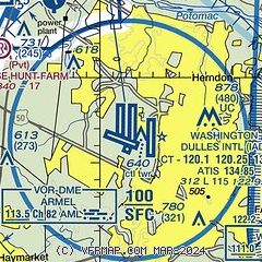
| Sectional chart |
|---|
|
CAUTION: Diagram may not be current
 Download PDF
of official airport diagram from the FAA
| Airport distance calculator |
|---|
|
|
| Sunrise and sunset |
|---|
|
Times for 11-Jun-2026
| | Local
(UTC-4) | | Zulu
(UTC) |
|---|
| Morning civil twilight | | 05:13 | | 09:13 |
| Sunrise | | 05:45 | | 09:45 |
| Sunset | | 20:34 | | 00:34 |
| Evening civil twilight | | 21:06 | | 01:06 |
|
| Current date and time |
|---|
| Zulu (UTC) | 12-Jun-2026 00:47:16 |
|---|
| Local (UTC-4) | 11-Jun-2026 20:47:16 |
|---|
|
| METAR |
|---|
| KIAD | 120032Z 00000KT 7SM -RA FEW028 BKN040CB OVC080 23/21 A2984 RMK AO2 PK WND 25041/2353 TSE32 TS MOV E CB E MOV E P0015 T02330211 $
|
KJYO
9nm NW | 120035Z AUTO 00000KT 10SM -RA SCT070 SCT090 BKN120 22/22 A2987 RMK AO2 LTG DSNT NE AND S
|
KHEF
14nm S | 120039Z 15004KT 10SM -RA BKN110 22/21 A2987 RMK AO2 LTG DSNT NE AND E AND SW TSE33 P0002 $
|
KGAI
19nm NE | 120016Z AUTO 27014G28KT 10SM -RA SCT060 OVC070 26/19 A2989 RMK AO2 PK WND 29034/0005 WSHFT 2356 LTG DSNT ALQDS RAB12 P0000
|
KDAA
19nm SE | 120012Z AUTO 28029G47KT 10SM -TSRA SCT075 31/18 A2983 RMK AO2 RAB12 TSE2355TSB05 PRESRR SLP103 $
|
|
| TAF |
|---|
| KIAD | 112300Z 1123/1224 22009KT 5SM -SHRA VCTS BKN050CB TEMPO 1123/1201 28024G47KT 2SM TSRA BKN025CB BKN050 FM120200 28003KT P6SM SCT060 BKN150 FM121300 23006KT P6SM FEW060 FM121600 28007KT P6SM FEW060 PROB30 1219/1223 3SM TSRA OVC040CB FM122300 24006KT P6SM BKN140
|
KDAA
19nm SE | 112353Z 1123/1302 22010G15KT 9999 VCTS BKN050CB BKN250 QNH2974INS TEMPO 1123/1202 VRB25G45KT 1600 +TSRA BKN012CB BECMG 1201/1202 28006KT 9999 NSW SCT050 BKN150 QNH2976INS BECMG 1212/1213 22006KT 9999 FEW060 QNH2978INS BECMG 1218/1219 28007KT 9999 VCTS FEW030CB BKN050 QNH2974INS TEMPO 1220/1224 VRB20G30KT 3200 TSRA BKN015CB TX36/1121Z TN22/1210Z LAST NO AMDS AFT 1201 NEXT 1212
|
|
| NOTAMs |
|---|
NOTAMs are issued by the DoD/FAA and will open in a separate window not controlled by AirNav.
|
|


