FAA INFORMATION EFFECTIVE 25 DECEMBER 2025
Location
| FAA Identifier: | GAI |
| Lat/Long: | 39-10-06.0000N 077-09-57.6000W
39-10.100000N 077-09.960000W
39.1683333,-77.1660000
(estimated) |
| Elevation: | 538.7 ft. / 164.2 m (surveyed) |
| Variation: | 09W (1985) |
| From city: | 3 miles NE of GAITHERSBURG, MD |
| Time zone: | UTC -5 (UTC -4 during Daylight Saving Time) |
| Zip code: | 20879 |
Airport Operations
| Airport use: | Open to the public |
| Activation date: | 08/1960 |
| Control tower: | no |
| ARTCC: | WASHINGTON CENTER |
| FSS: | LEESBURG FLIGHT SERVICE STATION |
| NOTAMs facility: | DCA (NOTAM-D service available) |
| Attendance: | MARCH-MAY 0800-1900, JUNE-SEPTEMBER 0800-2000, OCTOBER-FEBRUARY 0800-1800
UNATNDD CHRISTMAS DAY. FOR AFT HRS SVC CALL 301-963-8043. |
| Pattern altitude: | 1000 FT AGL (1539 FT MSL) TURBINE AND JET 1500 FT AGL (2039 FT MSL) HELICOPTERS 800 FT AGL (1339 FT MSL). |
| Wind indicator: | no |
| Segmented circle: | yes |
| Lights: | ACTVT REIL RWY 14 & 32; MIRL RWY 14/32 - CTAF. PAPI RWY 14 & 32 OPR CONSLY. |
| Beacon: | white-green (lighted land airport)
Operates sunset to sunrise. |
Airport Communications
| CTAF/UNICOM: | 123.075 |
| WX AWOS-3PT: | 128.275 (301-977-2971) |
| POTOMAC APPROACH: | 128.7 |
| POTOMAC DEPARTURE: | 128.7 |
| CLEARANCE DELIVERY: | 121.6 |
| TERPZ DP: | 128.7 |
| TRSTN STAR: | 126.75 |
| WX AWOS-3 at CGS (16 nm SE): | 121.225 (301-864-5497) |
| WX AWOS-3 at FDK (18 nm NW): | PHONE 301-600-1457 |
| WX AWOS-3 at JYO (19 nm W): | 125.225 (703-777-3781) |
| WX ASOS at IAD (19 nm SW): | 134.85 (571-250-7817) |
| WX AWOS-3 at FME (20 nm E): | 123.925 |
| WX ASOS at DCA (20 nm S): | 132.65 (276-200-0159) |
Nearby radio navigation aids
| VOR radial/distance | | VOR name | | Freq | | Var |
|---|
| FDKr154/17.6 | | FREDERICK VOR/DME | | 116.85 | | 08W |
| DCAr351/19.5 | | WASHINGTON VOR/DME | | 111.00 | | 09W |
| AMLr053/19.8 | | ARMEL VOR/DME | | 113.50 | | 08W |
| EMIr212/21.4 | | WESTMINSTER VORTAC | | 117.90 | | 08W |
| BALr281/23.5 | | BALTIMORE VORTAC | | 115.10 | | 11W |
| ADWr337/25.8 | | ANDREWS VORTAC | | 113.10 | | 10W |
| MRBr119/34.3 | | MARTINSBURG VORTAC | | 112.10 | | 07W |
| NDB name | | Hdg/Dist | | Freq | | Var | | ID |
|---|
| GEORGETOWN | | 001/14.4 | | 323 | | 09W | | GTN | --. - -. |
| ELLICOTT | | 259/19.4 | | 371 | | 11W | | FND | ..-. -. -.. |
| OXONN | | 356/25.0 | | 332 | | 11W | | VQK | ...- --.- -.- |
Airport Services
| Fuel available: | 100LL JET-A
100LL:FUEL TRUCK AVBL 0800-2000; REQUEST ON 122.85. SELF-SERVE 100LL AVAILABLE WITH CREDIT CARD. |
| Parking: | hangars and tiedowns |
| Airframe service: | MINOR |
| Powerplant service: | MAJOR |
| Bottled oxygen: | LOW |
| Bulk oxygen: | NONE |
Runway Information
Runway 14/32
| Dimensions: | 4202 x 75 ft. / 1281 x 23 m |
| Surface: | asphalt, in good condition |
| Runway edge lights: | medium intensity |
| RUNWAY 14 | | RUNWAY 32 |
| Latitude: | 39-10.310615N | | 39-09.890302N |
| Longitude: | 077-10.313343W | | 077-09.606908W |
| Elevation: | 493.3 ft. | | 538.7 ft. |
| Traffic pattern: | left | | right |
| Runway heading: | 136 magnetic, 127 true | | 316 magnetic, 307 true |
| Markings: | nonprecision, in good condition | | nonprecision, in good condition |
| Visual slope indicator: | 4-light PAPI on left (3.00 degrees glide path) | | 4-light PAPI on left (3.25 degrees glide path) |
| Runway end identifier lights: | yes | | yes |
| Touchdown point: | yes, no lights | | yes, no lights |
| Obstructions: | 44 ft. trees, 1406 ft. from runway, 197 ft. left of centerline, 27:1 slope to clear
RWY 14, 47 FT TREES, 169 FT R, 195 FT FM THR. | | 24 ft. trees, lighted, 978 ft. from runway, 190 ft. left of centerline, 32:1 slope to clear
RWY 32 HAS +15 FT RIDGE PARALLEL TO RWY 155 FT L; +6FT FENCE PARALLEL TO RWY 180 FT R. |
Airport Ownership and Management from official FAA records
| Ownership: | Publicly-owned |
| Owner: | MONTGOMERY COUNTY REV AUTH
101 MONROE ST 4TH FLOOR, SUITE 410
ROCKVILLE, MD 20850
Phone 301-762-9080 |
| Manager: | JUSTIN BOLLUM, C.M.
7940 AIRPARK ROAD, SUITE 410
GAITHERSBURG, MD 20879
Phone 301-978-7009
EXT. 1011 |
Additional Remarks
| - | NOISE ABATEMENT DEP RWY 32; TURN RIGHT TO AT LEAST 340 DEGS; JETS REFRAIN FROM RWY 32 TAKEOFF BTWN 2300-0700. |
| - | FOR CD CTC POTOMAC APCH AT 866-429-5882. |
| - | RWY 32 PAPI BAFFLED BYD 5 DEG L OF CRS DUE TO BLDG. |
| - | DEER & BIRDS ON & INVOF ARPT. |
| - | HELICOPTERS REFRAIN FM AIR TAXI OVER PAVED PARKING RAMPS. |
| - | RWY 14 HAS 30 FT DOWNSLOPE 75 FT L/R OF CNTRLN AT THR TO 150 FT BOTH SIDES. |
| - | ARPT NOT RECOMMENDED FOR ACFT WITH WINGSPAN IN EXCESS OF 79 FT & GROSS WT IN EXCESS OF 48000 POUNDS. |
| - | SOUTH RAMP NOT RECOMMENDED FOR AIRCRAFT WITH WINGSPAN GREATER THAN 79 FT OR WEIGHT GREATER THAN 40000 LBS. |
| - | BE ALERT SFRA PROCEDURES IN EFFECT. |
| - | PREFERRED CALM WIND RWY 14. |
Instrument Procedures
NOTE: All procedures below are presented as PDF files. If you need a reader for these files, you should download the free Adobe Reader.NOT FOR NAVIGATION. Please procure official charts for flight.
FAA instrument procedures published for use from 25 December 2025 at 0901z to 22 January 2026 at 0900z.
STARs - Standard Terminal Arrivals |
|---|
| TRSTN FOUR (RNAV) | |
2 pages:
[1] [2] (317KB) |
IAPs - Instrument Approach Procedures |
|---|
| RNAV (GPS) RWY 14 | |
download (229KB) |
| RNAV (GPS)-A | |
download (176KB) |
| NOTE: Special Alternate Minimums apply | |
download (45KB) |
Departure Procedures |
|---|
| CONLE FIVE (RNAV) | |
download (162KB) |
| FOXHL ONE (RNAV) | |
download (143KB) |
| LINSE TWO (RNAV) | |
download (150KB) |
| TERPZ EIGHT (RNAV) | |
2 pages:
[1] [2] (293KB) |
| NOTE: Special Take-Off Minimums/Departure Procedures apply | |
download (213KB) |
Other nearby airports with instrument procedures:
W50 - Davis Airport (5 nm N)
KCGS - College Park Airport (16 nm SE)
KFDK - Frederick Municipal Airport (18 nm NW)
KJYO - Leesburg Executive Airport (19 nm W)
KIAD - Washington Dulles International Airport (19 nm SW)
2W2 - Clearview Airpark (19 nm N)
KFME - Tipton Airport (20 nm E)
KDCA - Ronald Reagan Washington National Airport (20 nm S)
|
|

Road maps at:
MapQuest
Bing
Google
| Aerial photo |
|---|
WARNING: Photo may not be current or correct
 Photo taken 22-Sep-2016
looking north.
Photo taken 22-Sep-2016
looking north.
Do you have a better or more recent aerial photo of Montgomery County Airpark that you would like to share? If so, please send us your photo.
|
| Sectional chart |
|---|
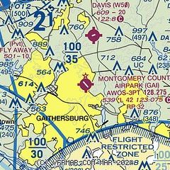
|
| Airport distance calculator |
|---|
|
|
| Sunrise and sunset |
|---|
|
Times for 16-Jan-2026
| | Local
(UTC-5) | | Zulu
(UTC) |
|---|
| Morning civil twilight | | 06:58 | | 11:58 |
| Sunrise | | 07:27 | | 12:27 |
| Sunset | | 17:10 | | 22:10 |
| Evening civil twilight | | 17:39 | | 22:39 |
|
| Current date and time |
|---|
| Zulu (UTC) | 16-Jan-2026 06:00:09 |
|---|
| Local (UTC-5) | 16-Jan-2026 01:00:09 |
|---|
|
| METAR |
|---|
| KGAI | 160456Z AUTO 30014G22KT 10SM FEW040 M07/M14 A2975 RMK AO2 PK WND 29026/0431 SLP097 T10671139 FZRANO
|
KCGS
16nm SE | 160540Z AUTO 28010G16KT 10SM CLR M05/M15 A2981 RMK AO2 T10501146
|
KFDK
18nm NW | 160535Z AUTO 29010G23KT 10SM FEW042 M06/M15 A2981 RMK AO2 T10611149 FZRANO $
|
KFME
19nm E | 160536Z AUTO 29010G15KT 10SM CLR M05/M13 A2980 RMK AO1
|
KIAD
19nm SW | 160552Z 30020G30KT 10SM CLR M06/M16 A2981 RMK AO2 PK WND 30030/0545 SLP097 T10561156 11050 21061 53012 $
|
KJYO
20nm W | 160555Z AUTO 10SM CLR M05/M13 A2981 RMK AO2
|
|
| TAF |
|---|
KIAD
19nm SW | 152103Z 1521/1624 31016G24KT P6SM FEW060 FM160600 30007KT P6SM FEW250 FM161100 21005KT P6SM FEW200 FM161600 19008G16KT P6SM BKN250
|
KDCA
20nm S | 152104Z 1521/1624 33019G26KT P6SM FEW060 FM160700 30007KT P6SM FEW250 FM161100 21005KT P6SM FEW200 FM161400 19008G16KT P6SM BKN250
|
KBWI
22nm E | 160520Z 1606/1712 29011G23KT P6SM FEW050 SCT250 FM161000 28009KT P6SM SCT200 FM161700 24008KT P6SM SCT150 FM161900 21008G15KT P6SM BKN120 FM162200 17007KT P6SM BKN100 FM170500 20006KT P6SM BKN060
|
|
| NOTAMs |
|---|
NOTAMs are issued by the DoD/FAA and will open in a separate window not controlled by AirNav.
|
|


