FAA INFORMATION EFFECTIVE 14 MAY 2026
Location
| FAA Identifier: | JAU |
| Lat/Long: | 36-20-02.7200N 084-09-46.6750W
36-20.045333N 084-09.777917W
36.3340889,-84.1629653
(estimated) |
| Elevation: | 1179.9 ft. / 359.6 m (surveyed) |
| Variation: | 03W (1990) |
| From city: | 1 mile E of JACKSBORO, TN |
| Time zone: | UTC -4 (UTC -5 during Standard Time) |
| Zip code: | 37757 |
Airport Operations
| Airport use: | Open to the public |
| Control tower: | no |
| ARTCC: | ATLANTA CENTER |
| FSS: | NASHVILLE FLIGHT SERVICE STATION |
| NOTAMs facility: | BNA (NOTAM-D service available) |
| Attendance: | MON-FRI 0900-1700, ALL SAT 0900-1500 |
| Wind indicator: | lighted |
| Segmented circle: | yes |
| Lights: | ACTVT REIL RWY 5 & 23; MIRL RWY 5/23 - CTAF. PAPI RWY 05 & 23 ON CONSLY. |
| Beacon: | white-green (lighted land airport)
Operates sunset to sunrise. |
Airport Communications
| CTAF/UNICOM: | 122.8 |
| WX AWOS-3: | 124.975 (423-566-6474) |
- APCH/DEP SVC PRVDD BY ATLANTA ARTCC ON FREQS 133.6/254.3 (HINCH MOUNTAIN RCAG).
Nearby radio navigation aids
| VOR radial/distance | | VOR name | | Freq | | Var |
|---|
| VXVr336/28.9 | | VOLUNTEER VORTAC | | 116.40 | | 03W |
Airport Services
| Fuel available: | 100LL JET-A |
| Parking: | hangars and tiedowns |
Runway Information
Runway 5/23
| Dimensions: | 4000 x 75 ft. / 1219 x 23 m |
| Surface: | asphalt, in good condition |
| Weight bearing capacity: | |
| Runway edge lights: | medium intensity |
| RUNWAY 5 | | RUNWAY 23 |
| Latitude: | 36-19.814833N | | 36-20.275833N |
| Longitude: | 084-10.069667W | | 084-09.486167W |
| Elevation: | 1133.7 ft. | | 1179.9 ft. |
| Traffic pattern: | left | | left |
| Runway heading: | 049 magnetic, 046 true | | 229 magnetic, 226 true |
| Markings: | basic, in good condition | | basic, in good condition |
| Visual slope indicator: | 2-light PAPI on left (3.00 degrees glide path) | | 2-light PAPI on left (3.00 degrees glide path) |
| Runway end identifier lights: | yes | | yes |
| Touchdown point: | yes, no lights | | yes, no lights |
| Obstructions: | 28 ft. trees, 630 ft. from runway, 111 ft. left of centerline, 15:1 slope to clear | | 9 ft. trees, 318 ft. from runway, 81 ft. left of centerline, 13:1 slope to clear |
Airport Ownership and Management from official FAA records
| Ownership: | Publicly-owned |
| Owner: | CAMPBELL COUNTY
COUNTY COURTHOUSE, PO BOX 435
JACKSBORO, TN 37757
Phone 423-562-2526 |
| Manager: | BERT LOUPE
610 MEMORIAL LANE
JACKSBORO, TN 37757
Phone 423-562-9966 |
Additional Remarks
| - | HIGH TRRN S-NE. |
| - | DEER & COYOTE ON RWY. |
| - | FOR CD CTC ATLANTA ARTCC AT 770-210-7692. |
Instrument Procedures
NOTE: All procedures below are presented as PDF files. If you need a reader for these files, you should download the free Adobe Reader.NOT FOR NAVIGATION. Please procure official charts for flight.
FAA instrument procedures published for use from 14 May 2026 at 0901Z to 11 June 2026 at 0900Z.
IAPs - Instrument Approach Procedures |
|---|
| RNAV (GPS) RWY 23 **CHANGED** | |
download (266KB) |
| NOTE: Special Take-Off Minimums/Departure Procedures apply | |
download (126KB) |
Other nearby airports with instrument procedures:
KSCX - Scott Municipal Airport (22 nm W)
18I - Mc Creary County Airport (24 nm NW)
KDKX - Knoxville Downtown Island Airport (26 nm SE)
1A6 - Middlesboro/Bell County Airport (26 nm NE)
KBYL - Williamsburg-Whitley County Airport (28 nm N)
|
|

Road maps at:
MapQuest
Bing
Google
| Aerial photo |
|---|
WARNING: Photo may not be current or correct
 Photo by Bill Lloyd
Taken in January 2018
looking west.
Photo by Bill Lloyd
Taken in January 2018
looking west.
Do you have a better or more recent aerial photo of Colonel Tommy C Stiner Airfield that you would like to share? If so, please send us your photo.
|
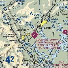
| Sectional chart |
|---|
|
| Airport distance calculator |
|---|
|
|
| Sunrise and sunset |
|---|
|
Times for 06-Jun-2026
| | Local
(UTC-4) | | Zulu
(UTC) |
|---|
| Morning civil twilight | | 05:50 | | 09:50 |
| Sunrise | | 06:20 | | 10:20 |
| Sunset | | 20:51 | | 00:51 |
| Evening civil twilight | | 21:21 | | 01:21 |
|
| Current date and time |
|---|
| Zulu (UTC) | 06-Jun-2026 20:25:19 |
|---|
| Local (UTC-4) | 06-Jun-2026 16:25:19 |
|---|
|
| METAR |
|---|
| KJAU | 061950Z AUTO VRB06KT 10SM SCT060 28/17 A3004 RMK A01
|
KOQT
19nm S | 061953Z AUTO VRB03KT 10SM CLR 30/15 A3007 RMK AO2 SLP168 T03000150
|
|
| TAF |
|---|
KTYS
32nm S | 061720Z 0618/0718 22008KT P6SM SCT250
|
|
| NOTAMs |
|---|
NOTAMs are issued by the DoD/FAA and will open in a separate window not controlled by AirNav.
|
|

