FAA INFORMATION EFFECTIVE 16 APRIL 2026
Location
| FAA Identifier: | JHW |
| Lat/Long: | 42-09-12.2200N 079-15-28.8820W
42-09.203667N 079-15.481367W
42.1533944,-79.2580228
(estimated) |
| Elevation: | 1723.3 ft. / 525.3 m (surveyed) |
| Variation: | 10W (2000) |
| From city: | 3 miles N of JAMESTOWN, NY |
| Time zone: | UTC -4 (UTC -5 during Standard Time) |
| Zip code: | 14701 |
Airport Operations
| Airport use: | Open to the public |
| Activation date: | 12/1938 |
| Control tower: | no |
| ARTCC: | CLEVELAND CENTER |
| FSS: | BUFFALO FLIGHT SERVICE STATION |
| NOTAMs facility: | JHW (NOTAM-D service available) |
| Attendance: | M-F 0600-1430 LCL |
| Wind indicator: | lighted |
| Segmented circle: | yes |
| Lights: | ACTVT MALSR RWY 25; REIL RWY 31; PAPI RWY 13 & 31; VASI RWY 07; HIRL RWY 07/25; MIRL RWY 13/31 & TWY LGTS - CTAF. |
| Beacon: | white-green (lighted land airport)
Operates sunset to sunrise. |
| Landing fee: | yes, LNDG FEE MULTI-ENGINE ACFT ONLY. |
| Fire and rescue: | ARFF index A |
Airport Communications
| CTAF/UNICOM: | 122.975 |
| WX AWOS-3PT: | 118.425 (716-664-6005) |
| BUFFALO APPROACH: | 126.05 |
| BUFFALO DEPARTURE: | 126.05 |
- APCH/DEP SVC PRVDD BY BUFFALO APCH (BUF) ON 126.05 0600-0000. APCH/DEP SVC PRVDD BY CLEVELAND ARTCC (ZOB) ON FREQ 127.075/292.175 (WATERFORD RCAG) 0000-0600.
Nearby radio navigation aids
| VOR radial/distance | | VOR name | | Freq | | Var |
|---|
| JHWr258/6.4 | | JAMESTOWN VOR/DME | | 114.70 | | 07W |
Airport Services
| Fuel available: | 100LL JET-A |
| Parking: | hangars and tiedowns |
| Airframe service: | MAJOR |
| Powerplant service: | MAJOR |
| Bottled oxygen: | NONE |
| Bulk oxygen: | HIGH/LOW |
Runway Information
Runway 7/25
| Dimensions: | 5300 x 100 ft. / 1615 x 30 m |
| Surface: | asphalt/grooved, in excellent condition |
| Weight bearing capacity: | | Single wheel: | 57.0 | | Double wheel: | 95.0 | | Double tandem: | 125.0 |
|
| Runway edge lights: | high intensity |
| RUNWAY 7 | | RUNWAY 25 |
| Latitude: | 42-08.889283N | | 42-09.339325N |
| Longitude: | 079-16.086917W | | 079-15.082413W |
| Elevation: | 1720.6 ft. | | 1718.6 ft. |
| Traffic pattern: | left | | left |
| Runway heading: | 069 magnetic, 059 true | | 249 magnetic, 239 true |
| Declared distances: | TORA:5300 TODA:5300 ASDA:5300 LDA:5300 | | TORA:5300 TODA:5300 ASDA:5300 LDA:5300 |
| Markings: | nonprecision, in good condition | | precision, in good condition |
| Visual slope indicator: | 4-box VASI on left (3.00 degrees glide path) | | |
| Approach lights: | | | MALSR: 1,400 foot medium intensity approach lighting system with runway alignment indicator lights |
| Touchdown point: | yes, no lights | | yes, no lights |
| Instrument approach: | | | ILS/DME |
Runway 13/31
| Dimensions: | 4499 x 100 ft. / 1371 x 30 m |
| Surface: | asphalt, in fair condition |
| Weight bearing capacity: | | Single wheel: | 31.0 | | Double wheel: | 56.0 |
|
| Runway edge lights: | medium intensity |
| RUNWAY 13 | | RUNWAY 31 |
| Latitude: | 42-09.488137N | | 42-09.129647N |
| Longitude: | 079-15.795170W | | 079-14.924162W |
| Elevation: | 1723.3 ft. | | 1707.2 ft. |
| Traffic pattern: | left | | left |
| Runway heading: | 129 magnetic, 119 true | | 309 magnetic, 299 true |
| Declared distances: | TORA:4499 TODA:4499 ASDA:4499 LDA:4499 | | TORA:4499 TODA:4499 ASDA:4499 LDA:4499 |
| Markings: | nonprecision, in good condition | | nonprecision, in good condition |
| Visual slope indicator: | 4-light PAPI on left (3.00 degrees glide path) | | 4-light PAPI on left (3.00 degrees glide path) |
| Runway end identifier lights: | | | yes |
| Touchdown point: | yes, no lights | | yes, no lights |
| Obstructions: | 69 ft. tree, 1400 ft. from runway, 240 ft. left of centerline, 17:1 slope to clear | | 61 ft. bldg, marked and lighted, 1200 ft. from runway, 300 ft. left of centerline, 16:1 slope to clear |
Airport Ownership and Management from official FAA records
| Ownership: | Publicly-owned |
| Owner: | CHAUTAUQUA COUNTY
NORTH ERIE ST., COUNTY OFFICE BLDGS
MAYVILLE, NY 14757
Phone 716-753-4800 |
| Manager: | JOHN MACHEMER
3163 AIRPORT DR
JAMESTOWN, NY 14701
Phone 716-581-0062 |
Additional Remarks
| A39-13/31 | PCR VALUE: 148/F/C/W/T |
| A39-07/25 | PCR VALUE: 250/F/B/W/T |
| - | DEER AND BIRDS ON & INVOF ARPT. |
| - | SNOW REMOVAL OPS AVBL DURING NORMAL ATTENDANCE HRS; SNOW REMOVAL MAY BE LIMITED ON HOLIDAYS & WEEKENDS. |
| - | FOR CD CTC BUFFALO APCH AT 716-626-6920, WHEN APCH CLSD CTC CLEVELAND ARTCC AT 440-774-0232. |
| - | ATTENDANCE HRS AND SERVICES AVAILABLE ARE SUBJECT TO CHANGE, CALL AIRPORT MANAGER AT 716-484-0204 TO CONFIRM. |
| - | RWY/TWY CONDITIONS NOT MONITORED OUTSIDE OF NORMAL ATTENDANCE HRS. |
| - | 24 HR PPR FOR AIR CARRIER OPS WITH MORE THAN 9 PAX SEATS. CONTACT ARPT MGR AT 716-484-0204. FOR EMERGENCIES AFTER HRS, CALL 911 FOR MUTUAL AID SERVICE. |
| - | ARFF INDEX B CPBL. |
Instrument Procedures
NOTE: All procedures below are presented as PDF files. If you need a reader for these files, you should download the free Adobe Reader.NOT FOR NAVIGATION. Please procure official charts for flight.
FAA instrument procedures published for use from 16 April 2026 at 0901Z to 14 May 2026 at 0900Z.
IAPs - Instrument Approach Procedures |
|---|
| ILS OR LOC RWY 25 **CHANGED** | |
download (292KB) |
| RNAV (GPS) RWY 07 **CHANGED** | |
download (206KB) |
| RNAV (GPS) RWY 13 **CHANGED** | |
download (225KB) |
| RNAV (GPS) RWY 25 **CHANGED** | |
download (270KB) |
| RNAV (GPS) RWY 31 **CHANGED** | |
download (235KB) |
| VOR RWY 25 **CHANGED** | |
download (173KB) |
| NOTE: Special Alternate Minimums apply | |
download (36KB) |
| NOTE: Special Take-Off Minimums/Departure Procedures apply | |
download (379KB) |
Other nearby airports with instrument procedures:
KDKK - Chautauqua County/Dunkirk Airport (20 nm N)
8G2 - Corry-Lawrence Airport (23 nm SW)
KBFD - Bradford Regional Airport (35 nm SE)
6G1 - Titusville Airport (39 nm SW)
KOLE - Cattaraugus County-Olean Airport (40 nm E)
|
|

Road maps at:
MapQuest
Bing
Google
| Aerial photo |
|---|
WARNING: Photo may not be current or correct
 taken on downwind 25, Lake Erie to the north
Do you have a better or more recent aerial photo of Chautauqua County/Jamestown Airport that you would like to share? If so, please send us your photo.
|
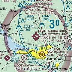
| Sectional chart |
|---|
|
| Airport distance calculator |
|---|
|
|
| Sunrise and sunset |
|---|
|
Times for 26-Apr-2026
| | Local
(UTC-4) | | Zulu
(UTC) |
|---|
| Morning civil twilight | | 05:51 | | 09:51 |
| Sunrise | | 06:21 | | 10:21 |
| Sunset | | 20:09 | | 00:09 |
| Evening civil twilight | | 20:39 | | 00:39 |
|
| Current date and time |
|---|
| Zulu (UTC) | 26-Apr-2026 10:03:39 |
|---|
| Local (UTC-4) | 26-Apr-2026 06:03:39 |
|---|
|
| METAR |
|---|
| KJHW | 260956Z AUTO 36003KT 3/4SM -RA BR FEW003 OVC010 07/07 A3004 RMK AO2 RAB34 CIG 006V012 SLP188 P0000 T00670067 RVRNO
|
|
| TAF |
|---|
| KJHW | 260536Z 2606/2706 07005KT 1/2SM FG BKN002 FM261200 08004KT 2SM BR BKN002 FM261400 07005KT P6SM BKN035 FM261600 06008KT P6SM BKN050 FM262300 07005KT P6SM FEW250
|
|
| NOTAMs |
|---|
NOTAMs are issued by the DoD/FAA and will open in a separate window not controlled by AirNav.
|
|


