FAA INFORMATION EFFECTIVE 27 NOVEMBER 2025
Location
| FAA Identifier: | JQD |
| Lat/Long: | 37-27-30.7720N 086-50-59.3670W
37-27.512867N 086-50.989450W
37.4585478,-86.8498242
(estimated) |
| Elevation: | 537 ft. / 163.7 m (surveyed) |
| Variation: | 02W (2000) |
| From city: | 3 miles NE of HARTFORD, KY |
| Time zone: | UTC -6 (UTC -5 during Daylight Saving Time) |
| Zip code: | 42320 |
Airport Operations
| Airport use: | Open to the public |
| Activation date: | 06/1984 |
| Control tower: | no |
| ARTCC: | INDIANAPOLIS CENTER |
| FSS: | LOUISVILLE FLIGHT SERVICE STATION |
| NOTAMs facility: | LOU (NOTAM-D service available) |
| Attendance: | MON - FRI 0900-1700
SVC AFT HR - AMGR. |
| Wind indicator: | lighted |
| Segmented circle: | yes |
| Lights: | DUSK-DAWN ACTVT PAPI RWY 03 & 21; MIRL RWY 03/21 - CTAF. |
| Beacon: | white-green (lighted land airport)
Operates sunset to sunrise. |
Airport Communications
| CTAF/UNICOM: | 122.8 |
| WX AWOS-3PT: | 132.1 (270-298-7936) |
| EVANSVILLE APPROACH: | 124.025 |
| EVANSVILLE DEPARTURE: | 124.025 |
- APCH/DEP SVC PRVDD BY INDIANAPOLIS ARTCC 0N FREQS 128.3/291.625 (EVANSVILLE RCAG) WHEN EVANSVILLE APCH CTL CLSD.
Nearby radio navigation aids
| VOR radial/distance | | VOR name | | Freq | | Var |
|---|
| OWBr143/22.8 | | OWENSBORO VOR/DME | | 108.65 | | 04W |
| MYSr229/(38.8) | | MYSTIC VOR | | 108.20 | | 01W |
Airport Services
| Fuel available: | 100LL |
| Parking: | hangars and tiedowns |
| Airframe service: | MAJOR |
| Powerplant service: | MAJOR |
| Bulk oxygen: | NONE |
Runway Information
Runway 3/21
| Dimensions: | 5003 x 75 ft. / 1525 x 23 m |
| Surface: | asphalt, in fair condition |
| Weight bearing capacity: | | PCN 10 /F/D/X/T | | Single wheel: | 27.0 |
|
| Runway edge lights: | medium intensity |
| RUNWAY 3 | | RUNWAY 21 |
| Latitude: | 37-27.138372N | | 37-27.887367N |
| Longitude: | 086-51.205412W | | 086-50.773437W |
| Elevation: | 530.1 ft. | | 537.0 ft. |
| Traffic pattern: | left | | left |
| Runway heading: | 027 magnetic, 025 true | | 207 magnetic, 205 true |
| Markings: | nonprecision, in fair condition | | nonprecision, in fair condition |
| Visual slope indicator: | 2-light PAPI on left (3.00 degrees glide path) | | 2-light PAPI on left (3.50 degrees glide path) |
| Runway end identifier lights: | yes | | yes |
| Touchdown point: | yes, no lights | | yes, no lights |
| Obstructions: | 19 ft. trees, 227 ft. from runway, 236 ft. right of centerline, 1:1 slope to clear
11 FT TREE 184 FT BYD THR 211 FT R OF CNTRLN. | | 67 ft. trees, 896 ft. from runway, 353 ft. right of centerline, 10:1 slope to clear
26 FT TREE 150 FT BYD THR 240 FT R OF CNTRLN. |
Airport Ownership and Management from official FAA records
| Ownership: | Publicly-owned |
| Owner: | OHIO COUNTY AIRPORT BOARD
340 AIRPORT ROAD
HARTFORD, KY 42347
Phone 270-298-3500 |
| Manager: | DAVID WOOSLEY
340 AIRPORT ROAD
HARTFORD, KY 42347
Phone 270-993-0867 |
Additional Remarks
| - | FOR CD CTC EVANSVILLE APCH AT 812-436-4690, WHEN APCH CLSD CTC INDIANAPOLIS ARTCC AT 317-247-2411. |
Instrument Procedures
NOTE: All procedures below are presented as PDF files. If you need a reader for these files, you should download the free Adobe Reader.NOT FOR NAVIGATION. Please procure official charts for flight.
FAA instrument procedures published for use from 27 November 2025 at 0901Z to 25 December 2025 at 0900Z.
IAPs - Instrument Approach Procedures |
|---|
| RNAV (GPS) RWY 03 | |
download (219KB) |
| RNAV (GPS) RWY 21 | |
download (240KB) |
| NOTE: Special Alternate Minimums apply | |
download (150KB) |
| NOTE: Special Take-Off Minimums/Departure Procedures apply | |
download (126KB) |
Other nearby airports with instrument procedures:
M21 - Muhlenberg County Airport (20 nm SW)
KOWB - Owensboro/Daviess County Regional Airport (23 nm NW)
2I0 - Madisonville Regional Airport (27 nm W)
I93 - Breckinridge County Airport (28 nm NE)
M20 - Leitchfield-Grayson County Airport (28 nm E)
|
|

Road maps at:
MapQuest
Bing
Google
| Aerial photo |
|---|
WARNING: Photo may not be current or correct

Do you have a better or more recent aerial photo of Ohio County Airport that you would like to share? If so, please send us your photo.
|
| Sectional chart |
|---|
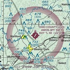
|
| Airport distance calculator |
|---|
|
|
| Sunrise and sunset |
|---|
|
Times for 20-Dec-2025
| | Local
(UTC-6) | | Zulu
(UTC) |
|---|
| Morning civil twilight | | 06:29 | | 12:29 |
| Sunrise | | 06:59 | | 12:59 |
| Sunset | | 16:31 | | 22:31 |
| Evening civil twilight | | 17:01 | | 23:01 |
|
| Current date and time |
|---|
| Zulu (UTC) | 20-Dec-2025 10:59:07 |
|---|
| Local (UTC-6) | 20-Dec-2025 04:59:07 |
|---|
|
| METAR |
|---|
KM21
20nm SW | 201035Z AUTO 00000KT 10SM CLR M02/M05 A3009 RMK AO2 T10201048
|
KOWB
22nm NW | 200956Z AUTO 20006KT 10SM CLR M03/M05 A3008 RMK AO2 SLP190 T10281050
|
K2I0
27nm W | 201035Z AUTO 17005KT 10SM CLR M02/M07 A3007 RMK AO2 T10211066
|
KKY8
30nm N | 201035Z AUTO 00000KT 10SM FEW070 M00/M05 A3007 RMK A01
|
KBWG
36nm SE | 201053Z AUTO 00000KT 10SM CLR M01/M06 A3010 RMK AO2 SLP195 T10061056 $
|
|
| TAF |
|---|
KOWB
22nm NW | 200520Z 2006/2106 13005KT P6SM FEW250 FM201100 18009KT P6SM FEW250 WS020/21040KT FM201700 20013G21KT P6SM FEW250 FM202100 23010KT P6SM FEW250
|
|
| NOTAMs |
|---|
NOTAMs are issued by the DoD/FAA and will open in a separate window not controlled by AirNav.
|
|

