FAA INFORMATION EFFECTIVE 14 MAY 2026
Location
| FAA Identifier: | 2I0 |
| Lat/Long: | 37-21-21.3390N 087-23-53.5910W
37-21.355650N 087-23.893183W
37.3559275,-87.3982197
(estimated) |
| Elevation: | 439.1 ft. / 133.8 m (surveyed) |
| Variation: | 03W (2010) |
| From city: | 5 miles NE of MADISONVILLE, KY |
| Time zone: | UTC -5 (UTC -6 during Standard Time) |
| Zip code: | 42431 |
Airport Operations
| Airport use: | Open to the public |
| Activation date: | 04/1944 |
| Control tower: | no |
| ARTCC: | INDIANAPOLIS CENTER |
| FSS: | LOUISVILLE FLIGHT SERVICE STATION |
| NOTAMs facility: | LOU (NOTAM-D service available) |
| Attendance: | HOLIDAY CLSD, ALL MON-SAT 0800-1700, ALL SUN CLSD |
| Wind indicator: | lighted |
| Segmented circle: | yes |
| Lights: | ACTVT ODALS RWY 23; REIL RWY 05; HIRL RWY 05/23 - CTAF. HIRL RWY 05/23 PRESET LOW INTST; INCR INTST - CTAF. |
| Beacon: | white-green (lighted land airport)
Operates sunset to sunrise. |
Airport Communications
| CTAF/UNICOM: | 122.7 |
| WX AWOS-3: | 126.475 (270-821-4554) |
| EVANSVILLE APPROACH: | 124.025 |
| EVANSVILLE DEPARTURE: | 124.025 |
| CLEARANCE DELIVERY: | 120.1 |
| WX AWOS-3 at M21 (14 nm SE): | 120.45 (270-338-7788) |
- APCH/DEP SVC PRVDD BY INDIANAPOLIS ARTCC ON FREQS 128.3/291.625 (EVANSVILLE RCAG) WHEN EVANSVILLE APCH CTL CLSD.
Nearby radio navigation aids
| VOR radial/distance | | VOR name | | Freq | | Var |
|---|
| OWBr209/25.7 | | OWENSBORO VOR/DME | | 108.65 | | 04W |
| PXVr150/38.5 | | POCKET CITY VORTAC | | 113.30 | | 03E |
Airport Services
| Fuel available: | 100LL JET-A+ |
| Parking: | hangars and tiedowns |
Runway Information
Runway 5/23
| Dimensions: | 6051 x 100 ft. / 1844 x 30 m |
| Surface: | asphalt, in fair condition |
| Weight bearing capacity: | | PCN 36 /F/C/X/T | | Single wheel: | 92.0 | | Double wheel: | 127.0 |
|
| Runway edge lights: | high intensity |
| RUNWAY 5 | | RUNWAY 23 |
| Latitude: | 37-21.045232N | | 37-21.666033N |
| Longitude: | 087-24.381777W | | 087-23.404522W |
| Elevation: | 439.1 ft. | | 418.2 ft. |
| Traffic pattern: | left | | left |
| Runway heading: | 054 magnetic, 051 true | | 234 magnetic, 231 true |
| Markings: | nonprecision, in fair condition | | nonprecision, in fair condition |
| Visual slope indicator: | 4-light PAPI on right (3.00 degrees glide path) | | 4-light PAPI on left (3.00 degrees glide path) |
| Approach lights: | | | ODALS: omnidirectional approach lighting system |
| Runway end identifier lights: | yes | | no |
| Touchdown point: | yes, no lights | | yes, no lights |
| Obstructions: | 61 ft. trees, 1321 ft. from runway, 396 ft. left of centerline, 18:1 slope to clear | | none |
Airport Ownership and Management from official FAA records
| Ownership: | Publicly-owned |
| Owner: | CITY OF MADISONVILLE
CITY HALL
MADISONVILLE, KY 42431
Phone 270-824-2110 |
| Manager: | VICTORIA DAVENPORT
162 AIRPORT ROAD
MADISONVILLE, KY 42431
Phone 270-836-8111
AFT HR - 270-871-5743. |
Additional Remarks
| - | FOR CD WHEN RCO 120.1 OTS CTC EVANSVILLE APCH AT 812-436-4689, WHEN APCH CLSD CTC INDIANAPOLIS ARTCC AT 317-247-2411. |
Instrument Procedures
NOTE: All procedures below are presented as PDF files. If you need a reader for these files, you should download the free Adobe Reader.NOT FOR NAVIGATION. Please procure official charts for flight.
FAA instrument procedures published for use from 14 May 2026 at 0901Z to 11 June 2026 at 0900Z.
IAPs - Instrument Approach Procedures |
|---|
| RNAV (GPS) RWY 05 **CHANGED** | |
download (233KB) |
| RNAV (GPS) RWY 23 **CHANGED** | |
download (253KB) |
| NOTE: Special Alternate Minimums apply | |
download (121KB) |
| NOTE: Special Take-Off Minimums/Departure Procedures apply | |
download (400KB) |
Other nearby airports with instrument procedures:
M21 - Muhlenberg County Airport (14 nm SE)
KOWB - Owensboro/Daviess County Regional Airport (25 nm NE)
2M0 - Princeton-Caldwell County Airport (26 nm SW)
KJQD - Ohio County Airport (27 nm E)
KTWT - Sturgis Municipal Airport (29 nm NW)
|
|

Road maps at:
MapQuest
Bing
Google
| Aerial photo |
|---|
WARNING: Photo may not be current or correct

Do you have a better or more recent aerial photo of Madisonville Regional Airport that you would like to share? If so, please send us your photo.
|
| Sectional chart |
|---|
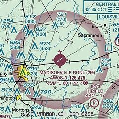
|
| Airport distance calculator |
|---|
|
|
| Sunrise and sunset |
|---|
|
Times for 15-May-2026
| | Local
(UTC-5) | | Zulu
(UTC) |
|---|
| Morning civil twilight | | 05:12 | | 10:12 |
| Sunrise | | 05:42 | | 10:42 |
| Sunset | | 19:50 | | 00:50 |
| Evening civil twilight | | 20:19 | | 01:19 |
|
| Current date and time |
|---|
| Zulu (UTC) | 16-May-2026 03:15:19 |
|---|
| Local (UTC-5) | 15-May-2026 22:15:19 |
|---|
|
| METAR |
|---|
| K2I0 | 160235Z AUTO 20005KT 10SM CLR 22/12 A2997 RMK AO2 T02190120
|
KM21
14nm SE | 160235Z AUTO 17003KT 10SM CLR 22/14 A2997 RMK AO2 T02190135
|
|
| TAF |
|---|
KOWB
24nm NE | 151720Z 1518/1618 20015G23KT P6SM SCT180 FM160100 17007KT P6SM BKN130 FM160900 18008KT P6SM -SHRA OVC080
|
|
| NOTAMs |
|---|
NOTAMs are issued by the DoD/FAA and will open in a separate window not controlled by AirNav.
|
|

