FAA INFORMATION EFFECTIVE 14 MAY 2026
Location
| FAA Identifier: | M21 |
| Lat/Long: | 37-13-34.4000N 087-09-23.0000W
37-13.573333N 087-09.383333W
37.2262222,-87.1563889
(estimated) |
| Elevation: | 428.2 ft. / 130.5 m (surveyed) |
| Variation: | 03W (2010) |
| From city: | 2 miles NE of GREENVILLE, KY |
| Time zone: | UTC -5 (UTC -6 during Standard Time) |
| Zip code: | 42345 |
Airport Operations
| Airport use: | Open to the public |
| Activation date: | 11/1960 |
| Control tower: | no |
| ARTCC: | MEMPHIS CENTER |
| FSS: | LOUISVILLE FLIGHT SERVICE STATION |
| NOTAMs facility: | LOU (NOTAM-D service available) |
| Attendance: | MON-FRI 0800-1700
AFT HR - AMGR. |
| Wind indicator: | yes |
| Segmented circle: | no |
| Lights: | ACTVT REIL RWY 06 & 24; PAPI RWY 06 & 24; MIRL RWY 06/24 - CTAF. |
| Beacon: | white-green (lighted land airport)
Operates sunset to sunrise. |
Airport Communications
| CTAF/UNICOM: | 123.0 |
| WX AWOS-3: | 120.45 (270-338-7788) |
| CAMPBELL APPROACH: | 118.1 |
| CAMPBELL DEPARTURE: | 118.1 |
| WX AWOS-3 at 2I0 (14 nm NW): | 126.475 (270-821-4554) |
Nearby radio navigation aids
| VOR radial/distance | | VOR name | | Freq | | Var |
|---|
| OWBr183/31.0 | | OWENSBORO VOR/DME | | 108.65 | | 04W |
| CKVr020/38.3 | | CLARKSVILLE VOR/DME | | 110.60 | | 01W |
Airport Services
| Fuel available: | 100LL JET-A+
100LL:FUEL AVBL H24 WITH CREDIT CARD. |
| Parking: | hangars and tiedowns |
| Airframe service: | MAJOR |
| Powerplant service: | MAJOR |
| Bottled oxygen: | NONE |
| Bulk oxygen: | NONE |
Runway Information
Runway 6/24
| Dimensions: | 4999 x 75 ft. / 1524 x 23 m |
| Surface: | asphalt, in good condition |
| Weight bearing capacity: | | PCN 6 /F/C/X/T | | Single wheel: | 18.0 |
|
| Runway edge lights: | medium intensity |
| RUNWAY 6 | | RUNWAY 24 |
| Latitude: | 37-13.342487N | | 37-13.805497N |
| Longitude: | 087-09.809407W | | 087-08.957405W |
| Elevation: | 414.8 ft. | | 428.2 ft. |
| Traffic pattern: | left | | left |
| Runway heading: | 059 magnetic, 056 true | | 239 magnetic, 236 true |
| Displaced threshold: | no | | 400 ft. |
| Declared distances: | | | TORA:5000 TODA:5000 ASDA:5000 LDA:4600 |
| Markings: | nonprecision, in good condition | | nonprecision, in good condition |
| Visual slope indicator: | 2-light PAPI on left (4.00 degrees glide path) | | 2-light PAPI on left (4.50 degrees glide path) |
| Runway end identifier lights: | yes | | yes |
| Touchdown point: | yes, no lights | | yes, no lights |
| Obstructions: | 80 ft. trees, 1745 ft. from runway, 417 ft. left of centerline, 19:1 slope to clear | | 62 ft. road, 1276 ft. from runway, 30 ft. both sides of centerline, 17:1 slope to clear
27:1 AT DSPLCD THR. |
Airport Ownership and Management from official FAA records
| Ownership: | Publicly-owned |
| Owner: | MUHLENBERG COUNTY
MUHLENBERG CO COURTHOUSE
GREENVILLE, KY 42345
Phone 270-338-9419 |
| Manager: | ED TACKETT
399 AIRPORT RD
GREENVILLE, KY 42345
Phone 270-225-8093 |
Additional Remarks
| - | FOR CD CTC CAMPBELL APCH AT 270-798-6441. |
Instrument Procedures
NOTE: All procedures below are presented as PDF files. If you need a reader for these files, you should download the free Adobe Reader.NOT FOR NAVIGATION. Please procure official charts for flight.
FAA instrument procedures published for use from 14 May 2026 at 0901Z to 11 June 2026 at 0900Z.
IAPs - Instrument Approach Procedures |
|---|
| RNAV (GPS) RWY 06 | |
download (218KB) |
| RNAV (GPS) RWY 24 | |
download (217KB) |
| NOTE: Special Take-Off Minimums/Departure Procedures apply | |
download (126KB) |
Other nearby airports with instrument procedures:
2I0 - Madisonville Regional Airport (14 nm NW)
KJQD - Ohio County Airport (20 nm NE)
KHVC - Hopkinsville-Christian County Airport (26 nm SW)
4M7 - Russellville-Logan County Airport (30 nm SE)
KOWB - Owensboro/Daviess County Regional Airport (31 nm N)
|
|

Road maps at:
MapQuest
Bing
Google
| Aerial photo |
|---|
WARNING: Photo may not be current or correct
 Photo taken 20-Nov-2015
looking northeast.
Photo taken 20-Nov-2015
looking northeast.
Do you have a better or more recent aerial photo of Muhlenberg County Airport that you would like to share? If so, please send us your photo.
|
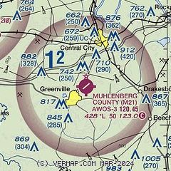
| Sectional chart |
|---|
|
| Airport distance calculator |
|---|
|
|
| Sunrise and sunset |
|---|
|
Times for 10-Jun-2026
| | Local
(UTC-5) | | Zulu
(UTC) |
|---|
| Morning civil twilight | | 04:58 | | 09:58 |
| Sunrise | | 05:29 | | 10:29 |
| Sunset | | 20:07 | | 01:07 |
| Evening civil twilight | | 20:38 | | 01:38 |
|
| Current date and time |
|---|
| Zulu (UTC) | 10-Jun-2026 18:22:14 |
|---|
| Local (UTC-5) | 10-Jun-2026 13:22:14 |
|---|
|
| METAR |
|---|
| KM21 | 101755Z AUTO 20011G15KT 10SM SCT034 SCT043 32/24 A2995 RMK AO2 T03180242 10318 20245
|
K2I0
14nm NW | 101735Z AUTO 21011G15KT 10SM BKN033 BKN055 32/23 A2996 RMK AO2 T03190229
|
|
| TAF |
|---|
KOWB
29nm N | 101720Z 1018/1118 21011KT P6SM SCT045 FM110000 20010KT P6SM SKC FM110500 18004KT P6SM SKC FM111500 21011G20KT P6SM FEW050
|
|
| NOTAMs |
|---|
NOTAMs are issued by the DoD/FAA and will open in a separate window not controlled by AirNav.
|
|

