FAA INFORMATION EFFECTIVE 20 MARCH 2025
Location
| FAA Identifier: | KLS |
| Lat/Long: | 46-07-04.8000N 122-53-54.1000W
46-07.080000N 122-53.901667W
46.1180000,-122.8983611
(estimated) |
| Elevation: | 20.1 ft. / 6.1 m (surveyed) |
| Variation: | 17E (2010) |
| From city: | 2 miles SE of KELSO, WA |
| Time zone: | UTC -7 (UTC -8 during Standard Time) |
| Zip code: | 98626 |
Airport Operations
| Airport use: | Open to the public |
| Activation date: | 05/1941 |
| Control tower: | no |
| ARTCC: | SEATTLE CENTER |
| FSS: | SEATTLE FLIGHT SERVICE STATION |
| NOTAMs facility: | KLS (NOTAM-D service available) |
| Attendance: | 0800-1700 |
| Wind indicator: | lighted, MIDFIELD, OTS INDEFLY. |
| Segmented circle: | yes |
| Lights: | ACTVT REIL RWY 12 & 30; PAPI RWY 12 & 30; MIRL RWY 12/30 - CTAF. |
| Beacon: | white-green (lighted land airport)
Operates sunset to sunrise. |
| International operations: | FLIGHT NOTIFICATION SERVICE (ADCUS) AVBL. |
Airport Communications
| CTAF/UNICOM: | 122.725 |
| WX AWOS-3PT: | 135.075 (360-577-1964) |
- APCH/DEP CTL SVC PRVDD BY SEATTLE ARTCC (ZSE) ON FREQS 124.2/317.6 (SCAPPOOSE RCAG).
- COMMUNICATIONS PRVDD BY SEATTLE RADIO ON FREQ 122.4 (SOUTHWEST WASHINGTON RCO).
Nearby radio navigation aids
| VOR radial/distance | | VOR name | | Freq | | Var |
|---|
| BTGr309/25.6 | | BATTLE GROUND VORTAC | | 116.60 | | 21E |
| NDB name | | Hdg/Dist | | Freq | | Var | | ID |
|---|
| BANKS | | 356/29.9 | | 356 | | 16E | | PND | .--. -. -.. |
Airport Services
| Fuel available: | 100LL JET-A
100LL:24 HR SELF SVC CREDIT CARD FUEL FAC 100LL. AFT HRS JET-A SVC CALL-OUT AVBL. |
| Parking: | tiedowns |
| Airframe service: | MAJOR |
| Powerplant service: | MAJOR |
| Bottled oxygen: | NONE |
| Bulk oxygen: | NONE |
Runway Information
Runway 12/30
| Dimensions: | 4391 x 100 ft. / 1338 x 30 m |
| Surface: | asphalt, in good condition |
| Weight bearing capacity: | | Single wheel: | 38.0 | | Double wheel: | 46.0 | | Double tandem: | 74.0 |
|
| Runway edge lights: | medium intensity
RY 12/30 MIRL NSTD SPACING. |
| RUNWAY 12 | | RUNWAY 30 |
| Latitude: | 46-07.358778N | | 46-06.802528N |
| Longitude: | 122-54.233723W | | 122-53.570880W |
| Elevation: | 20.0 ft. | | 15.9 ft. |
| Traffic pattern: | right | | left |
| Runway heading: | 123 magnetic, 140 true | | 303 magnetic, 320 true |
| Markings: | nonprecision, in good condition | | nonprecision, in good condition |
| Visual slope indicator: | 4-light PAPI on right (4.00 degrees glide path) | | 4-light PAPI on left (4.00 degrees glide path) |
| Runway end identifier lights: | yes | | yes |
| Touchdown point: | yes, no lights | | yes, no lights |
| Obstructions: | 45 ft. trees, 1300 ft. from runway, 110 ft. left of centerline, 24:1 slope to clear | | none
+3' HILL FROM 40' TO 200'; 105L. |
Airport Ownership and Management from official FAA records
| Ownership: | Publicly-owned |
| Owner: | CITY OF KELSO
203 S. PACIFIC AVE , PO BOX 819
KELSO, WA 98626
Phone 360-577-3370 |
| Manager: | CRAIG STOMMEL
PO BOX 818
KELSO, WA 98626
Phone 360-261-8268
ARPT OFC ADS (NOT FOR MAILING): 2215 B PARROTT WAY, KELSO, WA 98626 |
Additional Remarks
| - | NMRS FLOCKS OF BIRDS ON & INVOF ARPT. |
| - | NO FLD COND NOTAMS AVBL M-F 1700-0800. |
| - | FOR CD IF UNA TO CTC ON FSS FREQ, CTC SEATTLE ARTCC AT 253-351-3694. |
Instrument Procedures
NOTE: All procedures below are presented as PDF files. If you need a reader for these files, you should download the free Adobe Reader.NOT FOR NAVIGATION. Please procure official charts for flight.
FAA instrument procedures published for use from 20 March 2025 at 0901Z to 17 April 2025 at 0900z.
IAPs - Instrument Approach Procedures |
|---|
| RNAV (GPS) RWY 12 | |
download (256KB) |
| NOTE: Special Alternate Minimums apply | |
download (188KB) |
|
|---|
| KELSO TWO (OBSTACLE) (RNAV) | |
download (292KB) |
| NOTE: Special Take-Off Minimums/Departure Procedures apply | |
download (625KB) |
Other nearby airports with instrument procedures:
KSPB - Scappoose Airport (21 nm S)
KTDO - Ed Carlson Memorial Field/South Lewis County Airport (22 nm N)
KVUO - Pearson Field Airport (32 nm S)
KCLS - Chehalis-Centralia Airport (34 nm N)
KPDX - Portland International Airport (34 nm S)
|
|

Road maps at:
MapQuest
Bing
Google
| Aerial photo |
|---|
WARNING: Photo may not be current or correct
 Photo taken 22-Feb-2015
looking northwest.
Photo taken 22-Feb-2015
looking northwest.
Do you have a better or more recent aerial photo of Southwest Washington Regional Airport that you would like to share? If so, please send us your photo.
|
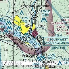
| Sectional chart |
|---|
|
CAUTION: Diagram may not be current

| Airport distance calculator |
|---|
|
|
| Sunrise and sunset |
|---|
|
Times for 12-Apr-2025
| | Local
(UTC-7) | | Zulu
(UTC) |
|---|
| Morning civil twilight | | 06:00 | | 13:00 |
| Sunrise | | 06:31 | | 13:31 |
| Sunset | | 19:53 | | 02:53 |
| Evening civil twilight | | 20:24 | | 03:24 |
|
| Current date and time |
|---|
| Zulu (UTC) | 12-Apr-2025 11:49:25 |
|---|
| Local (UTC-7) | 12-Apr-2025 04:49:25 |
|---|
|
| METAR |
|---|
| KKLS | 121056Z AUTO 00000KT 10SM OVC047 03/02 A3030 RMK AO2 SLP263 T00330022
|
|
| TAF |
|---|
KHIO
34nm S | 120520Z 1206/1306 32009KT P6SM BKN050 FM120900 VRB04KT P6SM FEW025 SCT050 FM122000 34009KT P6SM BKN050
|
KPDX
34nm S | 120849Z 1209/1306 32007KT P6SM BKN060
|
KTTD
40nm SE | 120520Z 1206/1306 VRB04KT P6SM BKN060 FM121800 29005KT P6SM BKN070
|
KAST
41nm W | 120520Z 1206/1306 30007KT P6SM SCT050 FM121800 32011KT P6SM BKN050
|
|
| NOTAMs |
|---|
NOTAMs are issued by the DoD/FAA and will open in a separate window not controlled by AirNav.
|
|


