FAA INFORMATION EFFECTIVE 16 APRIL 2026
Location
| FAA Identifier: | LXL |
| Lat/Long: | 45-56-56.6340N 094-20-49.3310W
45-56.943900N 094-20.822183W
45.9490650,-94.3470364
(estimated) |
| Elevation: | 1122.8 ft. / 342.2 m (surveyed) |
| Variation: | 03E (1995) |
| From city: | 2 miles S of LITTLE FALLS, MN |
| Time zone: | UTC -5 (UTC -6 during Standard Time) |
| Zip code: | 56345 |
Airport Operations
| Airport use: | Open to the public |
| Activation date: | 10/1947 |
| Control tower: | no |
| ARTCC: | MINNEAPOLIS CENTER |
| FSS: | PRINCETON FLIGHT SERVICE STATION |
| NOTAMs facility: | LXL (NOTAM-D service available) |
| Attendance: | MON-FRI 0800-1700 |
| Wind indicator: | lighted |
| Segmented circle: | no |
| Lights: | ACTVT OR INCR INTST REIL RWY 13 & 31; PAPI RWY 13 & 31; MIRL RWY 13/31; LIRL RWY 18/36 - CTAF. MIRL RWY 13/31 PRESET LOW INTST. |
| Beacon: | white-green (lighted land airport)
Operates sunset to sunrise. |
Airport Communications
| CTAF/UNICOM: | 122.8 |
| WX AWOS-3: | 119.450 (320-632-6791) |
| WX AWOS-3 at RYM (9 nm N): | 121.575 |
- APCH/DEP SVC PRVDD BY MINNEAPOLIS ARTCC ON FREQS 118.05/239.0 (BRAINERD RCAG).
Nearby radio navigation aids
| VOR radial/distance | | VOR name | | Freq | | Var |
|---|
| STCr330/26.9 | | ST CLOUD VOR/DME | | 112.10 | | 03E |
| AXNr084/36.9 | | ALEXANDRIA VOR/DME | | 115.95 | | 07E |
| NDB name | | Hdg/Dist | | Freq | | Var | | ID |
|---|
| RIPLEY | | 178/7.8 | | 404 | | 03E | | XCR | -..- -.-. .-. |
Airport Services
| Fuel available: | 100LL UL91
100LL:FUEL AVBL H24 VIA CREDIT CARD. |
| Parking: | hangars and tiedowns |
| Airframe service: | MINOR |
| Powerplant service: | NONE |
| Bottled oxygen: | NONE |
| Bulk oxygen: | NONE |
Runway Information
Runway 13/31
| Dimensions: | 4010 x 75 ft. / 1222 x 23 m
ADNL 500 FT OFF NW END MKD UNUSBL. |
| Surface: | asphalt, in fair condition |
| Weight bearing capacity: | | Single wheel: | 22.0 | | Double wheel: | 42.0 |
|
| Runway edge lights: | medium intensity |
| RUNWAY 13 | | RUNWAY 31 |
| Latitude: | 45-57.157092N | | 45-56.727377N |
| Longitude: | 094-21.066650W | | 094-20.349015W |
| Elevation: | 1119.2 ft. | | 1122.7 ft. |
| Traffic pattern: | left | | left |
| Runway heading: | 128 magnetic, 131 true | | 308 magnetic, 311 true |
| Markings: | nonprecision, in good condition | | nonprecision, in good condition |
| Visual slope indicator: | 4-light PAPI on right (3.00 degrees glide path) | | 4-light PAPI on left (3.00 degrees glide path) |
| Runway end identifier lights: | yes | | yes |
| Touchdown point: | yes, no lights | | yes, no lights |
Runway 18/36
| Dimensions: | 2858 x 60 ft. / 871 x 18 m |
| Surface: | asphalt, in excellent condition |
| Runway edge lights: | low intensity |
| RUNWAY 18 | | RUNWAY 36 |
| Latitude: | 45-57.181210N | | 45-56.711212N |
| Longitude: | 094-20.973847W | | 094-20.991485W |
| Elevation: | 1118.5 ft. | | 1118.8 ft. |
| Traffic pattern: | left | | left |
| Runway heading: | 178 magnetic, 181 true | | 358 magnetic, 001 true |
| Declared distances: | TORA:2856 TODA:2856 ASDA:2856 LDA:2856 | | TORA:2856 TODA:2856 ASDA:2856 LDA:2856 |
| Markings: | basic, in good condition | | basic, in good condition |
| Runway end identifier lights: | no | | no |
| Touchdown point: | yes, no lights | | yes, no lights |
Airport Ownership and Management from official FAA records
| Ownership: | Publicly-owned |
| Owner: | CITY LITTLE FALLS/MORRISON CO
100 7TH AVE NE
LITTLE FALLS, MN 56345-2300
Phone 320-616-5500 |
| Manager: | TOM OLSON
13129 AIRPORT RD
LITTLE FALLS, MN 56345-5777
Phone 320-616-5525 |
Additional Remarks
| A58-36 | 3 FT CROPS, 67 FT DIST, 87 FT R. |
| - | RWY 36 DEPS AVOID MINK RANCH 0.5 NM NE OF RWY. |
| - | GCO AVBL ON FREQ 121.725 THRU MINNEAPOLIS ARTCC & FLT SVCS. |
| - | FOR CD IF UNA VIA GCO CTC MINNEAPOLIS ARTCC AT 651-463-5588. |
Instrument Procedures
NOTE: All procedures below are presented as PDF files. If you need a reader for these files, you should download the free Adobe Reader.NOT FOR NAVIGATION. Please procure official charts for flight.
FAA instrument procedures published for use from 16 April 2026 at 0901Z to 14 May 2026 at 0900Z.
IAPs - Instrument Approach Procedures |
|---|
| RNAV (GPS) RWY 31 | |
download (273KB) |
| NOTE: Special Alternate Minimums apply | |
download (152KB) |
| NOTE: Special Take-Off Minimums/Departure Procedures apply | |
download (397KB) |
Other nearby airports with instrument procedures:
KRYM - Ray S Miller Army Airfield (9 nm N)
14Y - Todd Field Airport (22 nm W)
KSTC - St Cloud Sky Central Airport (27 nm SE)
D39 - Sauk Centre Municipal Airport (29 nm SW)
KBRD - Brainerd Lakes Regional Airport (29 nm N)
|
|

Road maps at:
MapQuest
Bing
Google
| Aerial photo |
|---|
WARNING: Photo may not be current or correct
 Photo by Shane Hjulberg
Photo taken 11-Apr-2009
Photo by Shane Hjulberg
Photo taken 11-Apr-2009
Do you have a better or more recent aerial photo of Little Falls/Morrison County Airport-Lindbergh Field that you would like to share? If so, please send us your photo.
|
| Sectional chart |
|---|
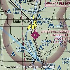
|
| Airport distance calculator |
|---|
|
|
| Sunrise and sunset |
|---|
|
Times for 13-May-2026
| | Local
(UTC-5) | | Zulu
(UTC) |
|---|
| Morning civil twilight | | 05:14 | | 10:14 |
| Sunrise | | 05:49 | | 10:49 |
| Sunset | | 20:39 | | 01:39 |
| Evening civil twilight | | 21:14 | | 02:14 |
|
| Current date and time |
|---|
| Zulu (UTC) | 14-May-2026 04:43:23 |
|---|
| Local (UTC-5) | 13-May-2026 23:43:23 |
|---|
|
| METAR |
|---|
| KLXL | 140415Z AUTO 00000KT 10SM CLR 08/02 A3003 RMK AO2
|
KRYM
8nm N | 140355Z AUTO 00000KT 10SM CLR 11/01 A2999 RMK AO2 SLP160 T01090006 $
|
|
| TAF |
|---|
KSTC
27nm SE | 131720Z 1318/1418 34012G20KT P6SM SKC FM140100 02005KT P6SM SKC FM140800 14008KT P6SM FEW250 FM141200 15012G20KT P6SM FEW250 FM141500 16017G30KT P6SM SCT100
|
KBRD
28nm N | 131720Z 1318/1418 36010G16KT P6SM FEW250 FM141000 15008G15KT P6SM FEW250 FM141600 16017G28KT P6SM SCT250
|
|
| NOTAMs |
|---|
NOTAMs are issued by the DoD/FAA and will open in a separate window not controlled by AirNav.
|
|

