FAA INFORMATION EFFECTIVE 25 DECEMBER 2025
Location
| FAA Identifier: | D39 |
| Lat/Long: | 45-42-23.7696N 094-55-59.6873W
45-42.396160N 094-55.994788W
45.7066027,-94.9332465
(estimated) |
| Elevation: | 1242.3 ft. / 378.7 m (surveyed) |
| Variation: | 03E (2000) |
| From city: | 2 miles SE of SAUK CENTRE, MN |
| Time zone: | UTC -6 (UTC -5 during Daylight Saving Time) |
| Zip code: | 56378 |
Airport Operations
| Airport use: | Open to the public |
| Activation date: | 05/1947 |
| Control tower: | no |
| ARTCC: | MINNEAPOLIS CENTER |
| FSS: | PRINCETON FLIGHT SERVICE STATION |
| NOTAMs facility: | PNM (NOTAM-D service available) |
| Attendance: | MON-FRI 0800-1700 |
| Pattern altitude: | 2042.3 ft. MSL |
| Wind indicator: | lighted |
| Segmented circle: | no |
| Lights: | RWY 14/32 MIRL PRESET TO LOW; TO INCR INTSTY AND ACTVT REIL RWY 14 & RWY 32; PAPI RWY 14 & RWY 32 - CTAF. |
| Beacon: | white-green (lighted land airport)
Operates sunset to sunrise. |
Airport Communications
| CTAF: | 122.9 |
| WX AWOS-3: | 118.475 (320-352-0136) |
| WX AWOS-3 at 14Y (12 nm N): | 118.650 (320-732-3508) |
| WX AWOS-3 at GHW (17 nm W): | 118.925 (320-634-5660) |
- APCH/DEP SVC PRVDD BY MINNEAPOLIS ARTCC ON FREQS 126.1/269.2 (ALEXANDRIA RCAG).
Nearby radio navigation aids
| VOR radial/distance | | VOR name | | Freq | | Var |
|---|
| AXNr133/19.6 | | ALEXANDRIA VOR/DME | | 115.95 | | 07E |
| BDHr009/36.3 | | WILLMAR VOR/DME | | 113.70 | | 04E |
| STCr281/37.9 | | ST CLOUD VOR/DME | | 112.10 | | 03E |
| NDB name | | Hdg/Dist | | Freq | | Var | | ID |
|---|
| RIPLEY | | 225/33.3 | | 404 | | 03E | | XCR | -..- -.-. .-. |
Airport Services
| Fuel available: | 100LL
100LL:FUEL AVBL 24 HRS WITH CREDIT CARD. |
| Parking: | hangars and tiedowns |
| Airframe service: | MAJOR |
| Powerplant service: | MINOR |
| Bottled oxygen: | NONE |
| Bulk oxygen: | NONE |
Runway Information
Runway 14/32
| Dimensions: | 3296 x 75 ft. / 1005 x 23 m |
| Surface: | asphalt, in good condition |
| Runway edge lights: | medium intensity |
| RUNWAY 14 | | RUNWAY 32 |
| Latitude: | 45-42.540453N | | 45-42.066988N |
| Longitude: | 094-56.183975W | | 094-55.806767W |
| Elevation: | 1240.2 ft. | | 1240.2 ft. |
| Traffic pattern: | left | | left |
| Runway heading: | 148 magnetic, 151 true | | 328 magnetic, 331 true |
| Markings: | nonprecision, in good condition | | nonprecision, in good condition |
| Visual slope indicator: | 4-light PAPI on left (3.00 degrees glide path) | | 4-light PAPI on left (3.00 degrees glide path) |
| Runway end identifier lights: | yes | | yes |
| Touchdown point: | yes, no lights | | yes, no lights |
Runway 8/26
| Dimensions: | 2404 x 120 ft. / 733 x 37 m |
| Surface: | turf, in fair condition |
| Runway edge markings: | RY 08 /26 MKD WITH YELLOW CONES. |
| Operational restrictions: | RY 08/26 NOT PLOWED WINTER MONTHS. |
| RUNWAY 8 | | RUNWAY 26 |
| Latitude: | 45-42.523385N | | 45-42.522408N |
| Longitude: | 094-56.276257W | | 094-55.711727W |
| Elevation: | 1239.4 ft. | | 1242.3 ft. |
| Traffic pattern: | left | | left |
| Runway heading: | 088 magnetic, 091 true | | 268 magnetic, 271 true |
| Touchdown point: | yes, no lights | | yes, no lights |
| Obstructions: | 6 ft. brush, 31 ft. from runway, 112 ft. right of centerline, 5:1 slope to clear | | 19 ft. road, 62 ft. from runway, 123 ft. right of centerline, 3:1 slope to clear |
Airport Ownership and Management from official FAA records
| Ownership: | Publicly-owned |
| Owner: | CITY OF SAUK CENTRE
320 OAK ST. S
SAUK CENTRE, MN 56378
Phone 320-352-2203 |
| Manager: | VICKI WILLER
320 OAK ST. S
SAUK CENTRE, MN 56378
Phone 320-352-2203 |
Additional Remarks
| - | FOR CD CTC MINNEAPOLIS ARTCC AT 651-463-5588. |
Instrument Procedures
NOTE: All procedures below are presented as PDF files. If you need a reader for these files, you should download the free Adobe Reader.NOT FOR NAVIGATION. Please procure official charts for flight.
FAA instrument procedures published for use from 25 December 2025 at 0901z to 22 January 2026 at 0900z.
IAPs - Instrument Approach Procedures |
|---|
| RNAV (GPS) RWY 14 | |
download (268KB) |
| RNAV (GPS) RWY 32 | |
download (226KB) |
| NOTE: Special Alternate Minimums apply | |
download |
| NOTE: Special Take-Off Minimums/Departure Procedures apply | |
download (156KB) |
Other nearby airports with instrument procedures:
14Y - Todd Field Airport (12 nm N)
KGHW - Glenwood Municipal Airport (17 nm W)
KAXN - Alexandria Regional Airport/Chandler Field (22 nm NW)
KPEX - Paynesville Municipal Airport (22 nm S)
KLXL - Little Falls/Morrison County Airport-Lindbergh Field (29 nm NE)
|
|

Road maps at:
MapQuest
Bing
Google
| Aerial photo |
|---|
WARNING: Photo may not be current or correct
 Photo taken 13-Jun-2020
looking north.
Photo taken 13-Jun-2020
looking north.
Do you have a better or more recent aerial photo of Sauk Centre Municipal Airport that you would like to share? If so, please send us your photo.
|
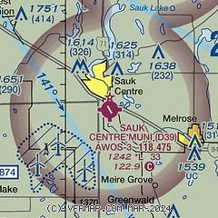
| Sectional chart |
|---|
|
| Airport distance calculator |
|---|
|
|
| Sunrise and sunset |
|---|
|
Times for 28-Dec-2025
| | Local
(UTC-6) | | Zulu
(UTC) |
|---|
| Morning civil twilight | | 07:27 | | 13:27 |
| Sunrise | | 08:01 | | 14:01 |
| Sunset | | 16:41 | | 22:41 |
| Evening civil twilight | | 17:16 | | 23:16 |
|
| Current date and time |
|---|
| Zulu (UTC) | 29-Dec-2025 03:14:45 |
|---|
| Local (UTC-6) | 28-Dec-2025 21:14:45 |
|---|
|
| METAR |
|---|
| KD39 | 290255Z AUTO 1 1/4SM -SN VV007 M14/M16 A2993 RMK AO2 T11421160
|
K14Y
12nm N | 118.65 320-732-3508
290255Z AUTO 00000KT 2 1/2SM -SN OVC014 M13/M16 A2993 RMK AO2 VIS 1 1/2V3
|
KGHW
17nm W | 290255Z AUTO 32022KT 3SM BLSN BR BKN005 OVC024 M15/M16 A2996 RMK AO2 PK WND 32028/0252 P0000 T11511164
|
|
| TAF |
|---|
KAXN
22nm NW | 281720Z 2818/2918 33021G32KT 1/2SM SN BLSN FZFG VV010 FM290000 32025G40KT 1/2SM SN BLSN FZFG VV008 FM290300 32024G38KT 2SM BLSN BR OVC012 FM290800 32017G30KT 4SM BLSN BR BKN020
|
|
| NOTAMs |
|---|
NOTAMs are issued by the DoD/FAA and will open in a separate window not controlled by AirNav.
|
|

