FAA INFORMATION EFFECTIVE 25 DECEMBER 2025
Location
| FAA Identifier: | MBO |
| Lat/Long: | 32-26-19.2000N 090-06-11.2000W
32-26.320000N 090-06.186667W
32.4386667,-90.1031111
(estimated) |
| Elevation: | 325.1 ft. / 99.1 m (surveyed) |
| Variation: | 01E (2000) |
| From city: | 2 miles SE of MADISON, MS |
| Time zone: | UTC -6 (UTC -5 during Daylight Saving Time) |
| Zip code: | 39110 |
Airport Operations
| Airport use: | Open to the public |
| Activation date: | 03/1941 |
| Control tower: | no |
| ARTCC: | MEMPHIS CENTER |
| FSS: | GREENWOOD FLIGHT SERVICE STATION |
| NOTAMs facility: | GWO (NOTAM-D service available) |
| Attendance: | MON-FRI 0600-1900, ALL SAT-SUN 0700-1800 |
| Wind indicator: | lighted |
| Segmented circle: | yes |
| Lights: | ACTVT PAPI RWY 17 & 35; MIRL RWY 17/35 - CTAF. |
| Beacon: | white-green (lighted land airport)
Operates sunset to sunrise. |
Airport Communications
| CTAF/UNICOM: | 122.8 |
| WX AWOS-3PT: | 119.125 (601-605-8137) |
| JACKSON APPROACH: | 123.9 ;333-152 125.25 ;153-332 |
| JACKSON DEPARTURE: | 123.9 ;333-152 125.25 ;153-332 |
| CLEARANCE DELIVERY: | 125.9 |
| IC: | 123.9 ;333-152 |
| WX ASOS at JAN (8 nm S): | 121.05 (601-769-1216) |
| WX ASOS at HKS (9 nm SW): | 120.625 (601-354-4037) |
| WX AWOS-3PT at JVW (18 nm SW): | 118.675 (601-857-3887) |
- APCH/DEP SVC PRVDD BY MEMPHIS ARTCC ON FREQS 132.5/259.1 (JACKSON RCAG) WHEN JACKSON APCH CTL CLSD.
Nearby radio navigation aids
| VOR radial/distance | | VOR name | | Freq | | Var |
|---|
| MHZ at field | | MAGNOLIA VORTAC | | 113.20 | | 01W |
| NDB name | | Hdg/Dist | | Freq | | Var | | ID |
|---|
| BRENZ | | 079/8.2 | | 260 | | 00W | | JH | .--- .... |
Airport Services
| Fuel available: | 100LL JET-A1+ |
| Parking: | hangars and tiedowns |
| Airframe service: | MINOR |
| Powerplant service: | MINOR |
| Bulk oxygen: | NONE |
Runway Information
Runway 17/35
| Dimensions: | 4444 x 75 ft. / 1355 x 23 m |
| Surface: | asphalt, in good condition |
| Weight bearing capacity: | |
| Runway edge lights: | medium intensity |
| RUNWAY 17 | | RUNWAY 35 |
| Latitude: | 32-26.685013N | | 32-25.954655N |
| Longitude: | 090-06.220960W | | 090-06.150657W |
| Elevation: | 325.1 ft. | | 314.0 ft. |
| Traffic pattern: | left | | left |
| Runway heading: | 174 magnetic, 175 true | | 354 magnetic, 355 true |
| Markings: | nonprecision, in good condition | | nonprecision, in good condition |
| Visual slope indicator: | 2-light PAPI on left (3.00 degrees glide path) | | 2-light PAPI on left (4.00 degrees glide path)
PAPI OTS INDEF. |
| Touchdown point: | yes, no lights | | yes, no lights |
| Obstructions: | 66 ft. trees, 1540 ft. from runway, 200 ft. right of centerline, 20:1 slope to clear | | 71 ft. trees, 1650 ft. from runway, 200 ft. left of centerline, 20:1 slope to clear |
Airport Ownership and Management from official FAA records
| Ownership: | Publicly-owned |
| Owner: | CITY OF MADISON
TOWN HALL (PO BOX 40)
MADISON, MS 39130
Phone 601-856-7116 |
| Manager: | GUY BOWERING
PO BOX 40
MADISON, MS 39130
Phone 601-853-1960 |
Additional Remarks
| - | WHEN APCH CLSD, FOR CD CTC MEMPHIS ARTCC AT 901-368-8453/8449. |
Instrument Procedures
NOTE: All procedures below are presented as PDF files. If you need a reader for these files, you should download the free Adobe Reader.NOT FOR NAVIGATION. Please procure official charts for flight.
FAA instrument procedures published for use from 25 December 2025 at 0901z to 22 January 2026 at 0900z.
IAPs - Instrument Approach Procedures |
|---|
| RNAV (GPS) RWY 17 | |
download (236KB) |
| RNAV (GPS) RWY 35 | |
download (212KB) |
| VOR RWY 17 | |
download (226KB) |
| NOTE: Special Alternate Minimums apply | |
download (181KB) |
| NOTE: Special Take-Off Minimums/Departure Procedures apply | |
download (303KB) |
Other nearby airports with instrument procedures:
KJAN - Jackson-Medgar Wiley Evers International Airport (8 nm S)
KHKS - Hawkins Field Airport (9 nm SW)
KJVW - John Bell Williams Airport (18 nm SW)
87I - Yazoo County Airport (32 nm NW)
M11 - Copiah County Airport (35 nm SW)
|
|

Road maps at:
MapQuest
Bing
Google
| Aerial photo |
|---|
WARNING: Photo may not be current or correct
 Taken in the Spring of 2019
looking south.
Taken in the Spring of 2019
looking south.
Do you have a better or more recent aerial photo of Bruce Campbell Field Airport that you would like to share? If so, please send us your photo.
|
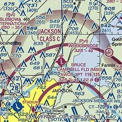
| Sectional chart |
|---|
|
| Airport distance calculator |
|---|
|
|
| Sunrise and sunset |
|---|
|
Times for 02-Jan-2026
| | Local
(UTC-6) | | Zulu
(UTC) |
|---|
| Morning civil twilight | | 06:36 | | 12:36 |
| Sunrise | | 07:03 | | 13:03 |
| Sunset | | 17:06 | | 23:06 |
| Evening civil twilight | | 17:33 | | 23:33 |
|
| Current date and time |
|---|
| Zulu (UTC) | 03-Jan-2026 01:20:46 |
|---|
| Local (UTC-6) | 02-Jan-2026 19:20:46 |
|---|
|
| METAR |
|---|
| KMBO | 021035Z AUTO 20007KT 10SM SCT039 SCT044 SCT050 12/08 A2989 RMK AO2
|
KJAN
7nm S | 030054Z 17007KT 10SM FEW038 BKN070 21/17 A2972 RMK AO2 SLP060 T02060167 $
|
KHKS
9nm SW | 030053Z 17006KT 10SM BKN044 OVC060 20/17 A2972 RMK AO2 SLP056 T02000167
|
KJVW
18nm SW | 030055Z AUTO 20005KT 10SM BKN045 OVC065 22/21 A2971 RMK AO2
|
|
| TAF |
|---|
KJAN
7nm S | 021747Z 0218/0318 18012G20KT P6SM VCSH BKN025 OVC035 FM022200 18008KT P6SM BKN035 FM030700 22005KT P6SM OVC012 FM030900 23003KT P6SM OVC007 FM031200 VRB03KT 4SM BR OVC007 FM031500 34006KT P6SM OVC007
|
KHKS
9nm SW | 021747Z 0218/0318 18012G20KT P6SM VCSH BKN025 OVC035 FM022200 18008KT P6SM BKN035 FM030700 22005KT P6SM OVC012 FM030900 23003KT P6SM OVC007 FM031200 VRB03KT 4SM BR OVC007 FM031500 34006KT P6SM OVC007
|
|
| NOTAMs |
|---|
NOTAMs are issued by the DoD/FAA and will open in a separate window not controlled by AirNav.
|
|

