FAA INFORMATION EFFECTIVE 02 OCTOBER 2025
Location
| FAA Identifier: | MLJ |
| Lat/Long: | 33-09-15.2120N 083-14-29.0670W
33-09.253533N 083-14.484450W
33.1542256,-83.2414075
(estimated) |
| Elevation: | 384.9 ft. / 117.3 m (surveyed) |
| Variation: | 04W (2000) |
| From city: | 4 miles N of MILLEDGEVILLE, GA |
| Time zone: | UTC -4 (UTC -5 during Standard Time) |
| Zip code: | 31061 |
Airport Operations
| Airport use: | Open to the public |
| Activation date: | 07/1959 |
| Control tower: | no |
| ARTCC: | ATLANTA CENTER |
| FSS: | MACON FLIGHT SERVICE STATION |
| NOTAMs facility: | MCN (NOTAM-D service available) |
| Attendance: | MON - SAT 0800-1700, ALL SUN BY PREARRANGEMENT |
| Wind indicator: | lighted, WIND INDCR LCTD N OF RWY 10 TDZ, ACTVT WIND INDCR LGT - CTAF. |
| Segmented circle: | yes |
| Lights: | ATCTVT MALSF RWY 10; REIL RWY 10 & 28; PAPI RWY 10 & 28; MIRL RWY 10/28 ARE PRESET ON MED INTST DUSK-2200; TO INCR INTST AND ACTVT AFTER 2200 - CTAF. |
| Beacon: | white-green (lighted land airport)
LCTD MID FIELD BESIDE FBO SOUTH OF TWY. Operates sunset to sunrise. |
Airport Communications
| CTAF/UNICOM: | 122.975 |
| WX AWOS-3: | 120.925 (478-445-7718) |
| ATLANTA APPROACH: | 124.2 |
| ATLANTA DEPARTURE: | 124.2 |
- ATLANTA LARGE TRACON PROVIDES APCH/DEP SVC 0615-2300 ON FREQ 124.2; ATLANTA ARTCC PROVIDES APCH/DEP SVC 2300-0615 ON FREQS 123.95/269.3 (MACON RCAG).
Nearby radio navigation aids
| NDB name | | Hdg/Dist | | Freq | | Var | | ID |
|---|
| CULVR | | 276/4.1 | | 380 | | 04W | | UMB | ..- -- -... |
Airport Services
| Fuel available: | 100LL JET-A+ |
| Parking: | tiedowns |
| Airframe service: | NONE |
| Powerplant service: | NONE |
| Bottled oxygen: | NONE |
| Bulk oxygen: | NONE |
Runway Information
Runway 10/28
| Dimensions: | 5506 x 100 ft. / 1678 x 30 m |
| Surface: | asphalt, in excellent condition |
| Weight bearing capacity: | | Single wheel: | 59.0 | | Double wheel: | 86.0 |
|
| Runway edge lights: | medium intensity |
| RUNWAY 10 | | RUNWAY 28 |
| Latitude: | 33-09.269260N | | 33-09.237783N |
| Longitude: | 083-15.023795W | | 083-13.945123W |
| Elevation: | 384.9 ft. | | 358.7 ft. |
| Traffic pattern: | left | | left |
| Runway heading: | 096 magnetic, 092 true | | 276 magnetic, 272 true |
| Displaced threshold: | no | | 82 ft. |
| Markings: | nonprecision, in good condition | | nonprecision, in good condition |
| Visual slope indicator: | 2-light PAPI on left (3.00 degrees glide path) | | 2-light PAPI on left (3.00 degrees glide path) |
| Approach lights: | MALSF: 1,400 foot medium intensity approach lighting system with sequenced flashers | | |
| Runway end identifier lights: | yes | | yes |
| Touchdown point: | yes, no lights | | yes, no lights |
| Obstructions: | 132 ft. trees, 2940 ft. from runway, 534 ft. left of centerline, 20:1 slope to clear | | 7 ft. road, 279 ft. from runway, 261 ft. left of centerline, 11:1 slope to clear |
Airport Ownership and Management from official FAA records
| Ownership: | Publicly-owned |
| Owner: | BALDWIN COUNTY
121 N. WILKINSON STREET, SUITE 314
MILLEDGEVILLE, GA 31061
Phone 478-445-4791 |
| Manager: | BRUCE HOOD
216 AIRPORT ROAD
MILLEDGEVILLE, GA 31061
Phone 478-457-4228
ALTN NR: 478-453-9358. |
Additional Remarks
| A39-10/28 | PCR VALUE: 237/F/C/X/T |
| - | DEER, GEESE, COYOTES, AND BIRDS ON AND INVOF ARPT. |
| - | RT - REFER TO FBO FOR PRKG. |
| - | ALL FIXED WING ACFT SHALL LVE PRKG BRAKE OFF IN CASE OF TOWING. |
| - | NO PUB PRKG AT W RAMP AND HNGRS. |
| - | FOR CD CTC ATLANTA APCH AT 678-364-6132, WHEN APCH CLSD CTC ATLANTA ARTCC AT 770-210-7692. |
| - | NO FIXED WING ACFT PRKG WI 100 FT OF FUEL TANK. |
| - | EXTSV FLT TRNG ON AND INVOF ARPT. |
| - | FLW FBO INSTRN FOR PRKG DUE TO TIGHT RAMP AREA. |
| - | BEARS RPRTD W OF RWY, USE CTN. |
| - | EXTSV BIRD ACT NEAR AER 10/28 FEB TO OCT DRG DALGT HRS. |
| - | TPA - LIGHT ACFT 1400 MSL, HEAVY ACFT 1900 MSL. |
| - | AMEL - EXP MARSHALLER UPON ENTERING MAIN RAMP. |
Instrument Procedures
NOTE: All procedures below are presented as PDF files. If you need a reader for these files, you should download the free Adobe Reader.NOT FOR NAVIGATION. Please procure official charts for flight.
FAA instrument procedures published for use from 02 October 2025 at 0901Z to 30 October 2025 at 0900z.
IAPs - Instrument Approach Procedures |
|---|
| RNAV (GPS) RWY 10 | |
download (186KB) |
| RNAV (GPS) RWY 28 | |
download (224KB) |
| NDB RWY 28 | |
download (213KB) |
| NOTE: Special Alternate Minimums apply | |
download (158KB) |
| NOTE: Special Take-Off Minimums/Departure Procedures apply | |
download (506KB) |
Other nearby airports with instrument procedures:
KOKZ - Kaolin Field Airport (23 nm SE)
KMAC - Macon Downtown Airport (26 nm SW)
KCPP - Greene County Regional Airport (27 nm N)
52A - Madison Municipal Airport (30 nm N)
KMCN - Middle Georgia Regional Airport (34 nm SW)
|
|

Road maps at:
MapQuest
Bing
Google
| Aerial photo |
|---|
WARNING: Photo may not be current or correct
 Photo by Russ Cartmill
Photo taken 06-Sep-2009
approaching Runway 10.
Photo by Russ Cartmill
Photo taken 06-Sep-2009
approaching Runway 10.
Do you have a better or more recent aerial photo of Baldwin County Regional Airport that you would like to share? If so, please send us your photo.
|
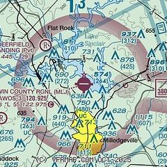
| Sectional chart |
|---|
|
| Airport distance calculator |
|---|
|
|
| Sunrise and sunset |
|---|
|
Times for 29-Oct-2025
| | Local
(UTC-4) | | Zulu
(UTC) |
|---|
| Morning civil twilight | | 07:24 | | 11:24 |
| Sunrise | | 07:50 | | 11:50 |
| Sunset | | 18:44 | | 22:44 |
| Evening civil twilight | | 19:09 | | 23:09 |
|
| Current date and time |
|---|
| Zulu (UTC) | 29-Oct-2025 14:57:35 |
|---|
| Local (UTC-4) | 29-Oct-2025 10:57:35 |
|---|
|
| METAR |
|---|
| KMLJ | 291435Z AUTO 10010KT 10SM BKN007 OVC011 12/11 A2986 RMK AO2
|
|
| TAF |
|---|
KMCN
35nm SW | 291136Z 2912/3012 09005KT P6SM BKN008 OVC015 FM291500 13010KT P6SM BKN008 OVC015 FM291800 15010KT 5SM -RA BR BKN012 OVC020 FM292100 20010KT 5SM -SHRA FEW015 BKN025 OVC035 FM300000 27008KT P6SM SCT025 BKN040 FM300600 25005KT P6SM SCT050 FM301000 24007KT P6SM BKN030
|
KWRB
37nm SW | 291100Z 2911/3017 12009KT 9999 OVC007 QNH2991INS BECMG 2914/2915 12009KT 9999 NSW OVC007 QNH2988INS BECMG 2916/2917 13010G20KT 9999 VCSH BKN006 BKN010 QNH2978INS TEMPO 2919/2923 14010G20KT 8000 -SHRA OVC015 BECMG 2923/2924 23009KT 9999 NSW BKN025 QNH2964INS TX15/2921Z TN08/3009Z
|
|
| NOTAMs |
|---|
NOTAMs are issued by the DoD/FAA and will open in a separate window not controlled by AirNav.
|
|


