FAA INFORMATION EFFECTIVE 16 APRIL 2026
Location
| FAA Identifier: | 52A |
| Lat/Long: | 33-36-43.6500N 083-27-37.6000W
33-36.727500N 083-27.626667W
33.6121250,-83.4604444
(estimated) |
| Elevation: | 694 ft. / 211.5 m (surveyed) |
| Variation: | 04W (1995) |
| From city: | 2 miles NE of MADISON, GA |
| Time zone: | UTC -4 (UTC -5 during Standard Time) |
| Zip code: | 30650 |
Airport Operations
| Airport use: | Open to the public |
| Control tower: | no |
| ARTCC: | ATLANTA CENTER |
| FSS: | MACON FLIGHT SERVICE STATION |
| NOTAMs facility: | MCN (NOTAM-D service available) |
| Attendance: | MON-SAT 0900-1500, ALL SUN 0900 - 1200 |
| Wind indicator: | lighted |
| Segmented circle: | yes |
| Lights: | ACTVT MIRL RY 14/32 & PAPI RY 14 - CTAF. |
| Beacon: | white-green (lighted land airport)
Operates sunset to sunrise. |
Airport Communications
| CTAF/UNICOM: | 122.8 |
| ATLANTA APPROACH: | 132.475 ;0615-2200 |
| ATLANTA DEPARTURE: | 132.475 ;0615-2200 |
| WX AWOS-3PT at D73 (15 nm NW): | 120.825 (678-635-3668) |
| WX AWOS-3 at CPP (16 nm E): | 124.525 (706-453-0017) |
| WX AWOS-3 at CVC (19 nm W): | 118.725 (770-385-7057) |
- APCH/DEP SVC PRVDD BY ATLANTA TRACON 0615-2200 ON FREQS 132.475/291.1 OTHER TIMES BY ATLANTA ARTCC ON FREQS 127.5/316.05 (ATHENS RCAG).
Nearby radio navigation aids
| VOR radial/distance | | VOR name | | Freq | | Var |
|---|
| AHNr199/21.2 | | ATHENS VOR/DME | | 116.95 | | 00E |
| NDB name | | Hdg/Dist | | Freq | | Var | | ID |
|---|
| BARROW COUNTY | | 167/20.4 | | 404 | | 05W | | BMW | -... -- .-- |
Airport Services
| Fuel available: | 100LL
100LL:SELF SVC FUEL AVBL 24 HRS WITH CREDIT CARD. |
| Parking: | tiedowns |
| Airframe service: | MINOR |
| Powerplant service: | MINOR |
| Bottled oxygen: | NONE |
| Bulk oxygen: | NONE |
Runway Information
Runway 14/32
| Dimensions: | 3806 x 75 ft. / 1160 x 23 m |
| Surface: | asphalt, in fair condition |
| Weight bearing capacity: | |
| Runway edge lights: | medium intensity |
| RUNWAY 14 | | RUNWAY 32 |
| Latitude: | 33-36.970000N | | 33-36.484500N |
| Longitude: | 083-27.863833W | | 083-27.389000W |
| Elevation: | 636.3 ft. | | 694.0 ft. |
| Traffic pattern: | left | | right |
| Runway heading: | 145 magnetic, 141 true | | 325 magnetic, 321 true |
| Displaced threshold: | no | | 1131 ft. |
| Declared distances: | TORA:3806 TODA:3806 ASDA:3740 LDA:3740 | | TORA:3806 TODA:3806 ASDA:3806 LDA:2675 |
| Markings: | nonprecision, in good condition | | nonprecision, in good condition |
| Visual slope indicator: | 2-light PAPI on left (3.00 degrees glide path) | | |
| Touchdown point: | yes, no lights | | yes, no lights |
| Obstructions: | 33 ft. trees, 215 ft. from runway, 248 ft. left of centerline
CONTROLLING OBSTRUCTION EXCEEDS A 45 DEGREE SLOPE | | 15 ft. road, 201 ft. from runway
9 FT SECURITY FENCE CROSSES APPH 175 FT FM RY END, AND 15 FT ROAD CROSSES APCH 200 FT FROM RY END. |
Airport Ownership and Management from official FAA records
| Ownership: | Publicly-owned |
| Owner: | CITY OF MADISON
132 NORTH MAIN STREET
MADISON, GA 30650
Phone 706-342-1251 |
| Manager: | JOHN KLIMM
132 NORTH MAIN STREET
MADISON, GA 30650
Phone 706-342-1251
ARPT PHONE 706-342-9857 |
Additional Remarks
| - | FOR CD CTC ATLANTA APCH AT 678-364-6131, WHEN APCH CLSD CTC ATLANTA ARTCC AT 770-210-7692. |
Instrument Procedures
NOTE: All procedures below are presented as PDF files. If you need a reader for these files, you should download the free Adobe Reader.NOT FOR NAVIGATION. Please procure official charts for flight.
FAA instrument procedures published for use from 16 April 2026 at 0901Z to 14 May 2026 at 0900Z.
IAPs - Instrument Approach Procedures |
|---|
| RNAV (GPS) RWY 14 | |
download (195KB) |
| VOR/DME-A | |
download (175KB) |
| NOTE: Special Take-Off Minimums/Departure Procedures apply | |
download (189KB) |
Other nearby airports with instrument procedures:
D73 - Cy Nunnally Memorial Airport (15 nm NW)
KCPP - Greene County Regional Airport (16 nm E)
KCVC - Covington Municipal Airport (19 nm W)
KAHN - Athens/Ben Epps Airport (21 nm N)
KWDR - Barrow County Airport (25 nm NW)
|
|

Road maps at:
MapQuest
Bing
Google
| Aerial photo |
|---|
WARNING: Photo may not be current or correct

Do you have a better or more recent aerial photo of Madison Municipal Airport that you would like to share? If so, please send us your photo.
|
| Sectional chart |
|---|
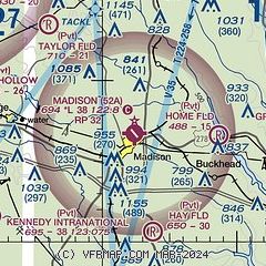
|
CAUTION: Diagram may not be current

| Airport distance calculator |
|---|
|
|
| Sunrise and sunset |
|---|
|
Times for 28-Apr-2026
| | Local
(UTC-4) | | Zulu
(UTC) |
|---|
| Morning civil twilight | | 06:23 | | 10:23 |
| Sunrise | | 06:49 | | 10:49 |
| Sunset | | 20:13 | | 00:13 |
| Evening civil twilight | | 20:40 | | 00:40 |
|
| Current date and time |
|---|
| Zulu (UTC) | 28-Apr-2026 22:37:14 |
|---|
| Local (UTC-4) | 28-Apr-2026 18:37:14 |
|---|
|
| METAR |
|---|
KD73
15nm NW | 282215Z AUTO 10SM OVC015 18/16 A3009 RMK AO2 T01800157
|
KCPP
16nm E | 282215Z AUTO 25007KT 10SM OVC014 19/17 A3010 RMK AO2
|
KCVC
19nm W | 282215Z AUTO 00000KT 10SM OVC014 19/17 A3007 RMK AO2
|
KAHN
21nm N | 282224Z VRB05KT 10SM SCT017 19/15 A3007 RMK AO2 T01940150
|
KWDR
25nm NW | 282215Z 10SM OVC016 18/15 A3010 RMK AO2 P0001 LTG DSNT NW
|
KMLJ
30nm S | 282215Z AUTO 00000KT 10SM CLR 19/16 A3007 RMK AO2
|
|
| TAF |
|---|
KAHN
21nm N | 281739Z 2818/2918 19004KT P6SM SCT005 BKN012 TEMPO 2818/2819 BKN006 OVC012 FM290100 00000KT P6SM BKN040 FM290300 00000KT P6SM -SHRA OVC012 PROB30 2904/2910 4SM -TSRA OVC012CB FM291600 25010G18KT P6SM SCT020
|
|
| NOTAMs |
|---|
NOTAMs are issued by the DoD/FAA and will open in a separate window not controlled by AirNav.
|
|


