FAA INFORMATION EFFECTIVE 14 MAY 2026
Location
| FAA Identifier: | D73 |
| Lat/Long: | 33-46-57.1000N 083-41-34.1000W
33-46.951667N 083-41.568333W
33.7825278,-83.6928056
(estimated) |
| Elevation: | 875.2 ft. / 266.8 m (surveyed) |
| Variation: | 04W (2000) |
| From city: | 1 mile SE of MONROE, GA |
| Time zone: | UTC -4 (UTC -5 during Standard Time) |
| Zip code: | 30655 |
Airport Operations
| Airport use: | Open to the public |
| Activation date: | 02/1961 |
| Control tower: | no |
| ARTCC: | ATLANTA CENTER |
| FSS: | MACON FLIGHT SERVICE STATION |
| NOTAMs facility: | MCN (NOTAM-D service available) |
| Attendance: | MON-FRI 0700-1700 |
| Wind indicator: | lighted |
| Segmented circle: | yes |
| Lights: | DUSK-2200. MIRL RY 03/21 PRESET LOW INTST DUSK-2200; TO INCR INTST & ACTVT MIRL RY 03/21 AND PAPI RYS 03 & 21 AFTER 2200 - CTAF. |
| Beacon: | white-green (lighted land airport)
Operates sunset to sunrise. |
Airport Communications
| CTAF: | 122.9 |
| WX AWOS-3PT: | 120.825 (678-635-3668) |
| ATLANTA APPROACH: | 126.975 |
| ATLANTA DEPARTURE: | 126.975 |
| BOKRT STAR: | 119.8 |
| WRGNZ STAR: | 128.575 |
| WX AWOS-3 at CVC (12 nm SW): | 118.725 (770-385-7057) |
| WX AWOS-3 at WDR (12 nm N): | 118.575 (770-868-0642) |
| WX AWOS-3PT at LZU (18 nm NW): | PHONE 770-339-7753 |
Nearby radio navigation aids
| VOR radial/distance | | VOR name | | Freq | | Var |
|---|
| AHNr242/20.8 | | ATHENS VOR/DME | | 116.95 | | 00E |
| NDB name | | Hdg/Dist | | Freq | | Var | | ID |
|---|
| BARROW COUNTY | | 214/10.5 | | 404 | | 05W | | BMW | -... -- .-- |
Airport Services
| Fuel available: | 100LL |
| Parking: | tiedowns |
| Airframe service: | MAJOR |
| Powerplant service: | MAJOR |
| Bottled oxygen: | NONE |
| Bulk oxygen: | NONE |
Runway Information
Runway 3/21
| Dimensions: | 5000 x 75 ft. / 1524 x 23 m |
| Surface: | asphalt, in excellent condition |
| Weight bearing capacity: | | Single wheel: | 14.5 | | Double wheel: | 18.0 |
|
| Runway edge lights: | medium intensity |
| RUNWAY 3 | | RUNWAY 21 |
| Latitude: | 33-46.599660N | | 33-47.302998N |
| Longitude: | 083-41.825378W | | 083-41.310547W |
| Elevation: | 875.2 ft. | | 824.1 ft. |
| Traffic pattern: | left | | left |
| Runway heading: | 035 magnetic, 031 true | | 215 magnetic, 211 true |
| Markings: | nonprecision, in good condition | | nonprecision, in good condition |
| Visual slope indicator: | 2-light PAPI on left (4.00 degrees glide path) | | 2-light PAPI on left (3.50 degrees glide path) |
| Touchdown point: | yes, no lights | | yes, no lights |
| Obstructions: | 86 ft. trees, 874 ft. from runway, 326 ft. right of centerline, 7:1 slope to clear
1'-4' FT BERM, 1'-200' FROM THRESHOLD, 240' RIGHT OF CENTERLINE | | 21 ft. trees, 243 ft. from runway, 253 ft. left of centerline, 2:1 slope to clear |
Airport Ownership and Management from official FAA records
| Ownership: | Publicly-owned |
| Owner: | CITY OF MONROE
CITY HALL, PO BOX 1249
MONROE, GA 30655
Phone 770-267-7536 |
| Manager: | CHRIS CROY
215 NORTH BROAD STREET
MONROE, GA 30655
Phone 770-266-5172 |
Additional Remarks
| - | GLIDER OPS 10 NM RADIUS SFC - 5000 FT. |
| - | DEER ON & INVOF ARPT. |
| - | FOR CD CTC ATLANTA APCH AT 678-364-6131. |
Instrument Procedures
NOTE: All procedures below are presented as PDF files. If you need a reader for these files, you should download the free Adobe Reader.NOT FOR NAVIGATION. Please procure official charts for flight.
FAA instrument procedures published for use from 14 May 2026 at 0901Z to 11 June 2026 at 0900Z.
STARs - Standard Terminal Arrivals |
|---|
| BUKHD THREE (RNAV) | |
download (190KB) |
| DEHAN THREE (RNAV) | |
2 pages:
[1] [2] (326KB) |
| SWTEE TWO (RNAV) | |
download (142KB) |
| WRGNZ THREE (RNAV) | |
download (245KB) |
IAPs - Instrument Approach Procedures |
|---|
| RNAV (GPS) RWY 03 | |
download (226KB) |
| NOTE: Special Alternate Minimums apply | |
download (153KB) |
| NOTE: Special Take-Off Minimums/Departure Procedures apply | |
download (479KB) |
Other nearby airports with instrument procedures:
KCVC - Covington Municipal Airport (12 nm SW)
KWDR - Barrow County Airport (12 nm N)
52A - Madison Municipal Airport (15 nm SE)
KLZU - Gwinnett County Airport-Briscoe Field (18 nm NW)
KAHN - Athens/Ben Epps Airport (21 nm NE)
|
|

Road maps at:
MapQuest
Bing
Google
| Aerial photo |
|---|
WARNING: Photo may not be current or correct
 Photo by Tim Vogt
Photo taken 05-Apr-2015
looking north.
Photo by Tim Vogt
Photo taken 05-Apr-2015
looking north.
Do you have a better or more recent aerial photo of Cy Nunnally Memorial Airport that you would like to share? If so, please send us your photo.
|
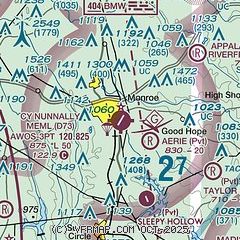
| Sectional chart |
|---|
|
| Airport distance calculator |
|---|
|
|
| Sunrise and sunset |
|---|
|
Times for 31-May-2026
| | Local
(UTC-4) | | Zulu
(UTC) |
|---|
| Morning civil twilight | | 05:58 | | 09:58 |
| Sunrise | | 06:26 | | 10:26 |
| Sunset | | 20:38 | | 00:38 |
| Evening civil twilight | | 21:07 | | 01:07 |
|
| Current date and time |
|---|
| Zulu (UTC) | 31-May-2026 07:24:50 |
|---|
| Local (UTC-4) | 31-May-2026 03:24:50 |
|---|
|
| METAR |
|---|
| KD73 | 310655Z AUTO 10SM CLR A2996 RMK AO2
|
KCVC
12nm SW | 310655Z AUTO VRB03KT 10SM FEW006 SCT013 SCT049 21/21 A2995 RMK AO2
|
KWDR
12nm N | 310655Z 10SM BKN080 21/20 A2999 RMK AO2
|
KLZU
18nm NW | 310656Z AUTO 08006KT 10SM BKN047 BKN060 A2997 RMK AO2 SLPNO FZRANO $
|
|
| TAF |
|---|
KAHN
21nm NE | 310543Z 3106/0106 00000KT P6SM VCSH SCT006 BKN050 FM310800 06004KT P6SM BKN006 FM311100 05009KT P6SM -SHRA OVC015 FM311600 06010KT P6SM OVC012 PROB30 3122/0104 4SM -SHRA OVC008
|
|
| NOTAMs |
|---|
NOTAMs are issued by the DoD/FAA and will open in a separate window not controlled by AirNav.
|
|


