FAA INFORMATION EFFECTIVE 27 NOVEMBER 2025
Location
| FAA Identifier: | MCN |
| Lat/Long: | 32-41-34.2000N 083-38-57.2000W
32-41.570000N 083-38.953333W
32.6928333,-83.6492222
(estimated) |
| Elevation: | 354.2 ft. / 108.0 m (surveyed) |
| Variation: | 06W (2020) |
| From city: | 9 miles S of MACON, GA |
| Time zone: | UTC -5 (UTC -4 during Daylight Saving Time) |
| Zip code: | 31216 |
Airport Operations
| Airport use: | Open to the public |
| Activation date: | 03/1942 |
| Control tower: | yes |
| ARTCC: | ATLANTA CENTER |
| FSS: | MACON FLIGHT SERVICE STATION |
| NOTAMs facility: | MCN (NOTAM-D service available) |
| Attendance: | 0500-2000
FOR SVC AFT HRS HIGHNOTE AVIATION - 478-957-9791. |
| Wind indicator: | lighted |
| Segmented circle: | yes |
| Lights: | ACTVT MALSR RWY 05; REIL RWY 23 & 32; HIRL RWY 05/23; MIRL RWY 14/32 & TWY LGTS - CTAF. |
| Beacon: | white-green (lighted land airport)
Operates sunset to sunrise. |
| Fire and rescue: | ARFF index A |
Airport Communications
| CTAF: | 128.2 |
| UNICOM: | 122.95 |
| ATIS: | 120.775 |
| WX ASOS: | PHONE 478-795-1120 |
| MACON GROUND: | 121.65 [0800-2000] |
| MACON TOWER: | 128.2 257.8 [0800-2000] |
| ATLANTA APPROACH: | 124.2 |
| ATLANTA DEPARTURE: | 124.2 |
| EMERG: | 121.5 |
| TRSA: | 124.2 |
| WX AWOS-3 at PXE (12 nm SW): | 123.825 (478-987-8768) |
- ATLANTA LARGE TRACON PROVIDES APCH/DEP SVC 0615-2300 ON FREQ 124.2/279.6; ATLANTA ARTCC PROVIDES APCH/DEP SVC 2300-0615 ON FREQS 134.5/360.75 (MACON RCAG).
Nearby radio navigation aids
| VOR radial/distance | | VOR name | | Freq | | Var |
|---|
| VNAr344/29.8 | | VIENNA VORTAC | | 116.50 | | 01E |
| NDB name | | Hdg/Dist | | Freq | | Var | | ID |
|---|
| CULVR | | 226/37.0 | | 380 | | 04W | | UMB | ..- -- -... |
| LINDBERGH | | 041/38.8 | | 242 | | 04W | | LKG | .-.. -.- --. |
Airport Services
| Fuel available: | 100LL JET-A |
| Parking: | hangars and tiedowns |
| Airframe service: | MAJOR |
| Powerplant service: | MAJOR |
| Bottled oxygen: | HIGH/LOW |
| Bulk oxygen: | NONE |
Runway Information
Runway 5/23
| Dimensions: | 6500 x 150 ft. / 1981 x 46 m |
| Surface: | asphalt/grooved, in good condition |
| Weight bearing capacity: | | PCN 54 /F/B/W/U | | Single wheel: | 80.0 | | Double wheel: | 128.0 | | Double tandem: | 237.0 |
|
| Runway edge lights: | high intensity |
| RUNWAY 5 | | RUNWAY 23 |
| Latitude: | 32-41.161132N | | 32-41.878952N |
| Longitude: | 083-39.638048W | | 083-38.696658W |
| Elevation: | 331.0 ft. | | 354.2 ft. |
| Traffic pattern: | left | | right |
| Runway heading: | 054 magnetic, 048 true | | 234 magnetic, 228 true |
| Declared distances: | TORA:6501 TODA:6501 ASDA:6221 LDA:6221 | | TORA:6501 TODA:6501 ASDA:6426 LDA:6426 |
| Markings: | precision, in good condition | | nonprecision, in good condition |
| Visual slope indicator: | | | 4-light PAPI on left (3.00 degrees glide path) |
| RVR equipment: | touchdown | | rollout |
| Approach lights: | MALSR: 1,400 foot medium intensity approach lighting system with runway alignment indicator lights | | |
| Runway end identifier lights: | | | yes |
| Touchdown point: | yes, no lights | | yes, no lights |
| Instrument approach: | ILS | | |
| Obstructions: | 27 ft. trees, 1540 ft. from runway, 450 ft. right of centerline | | 47 ft. trees, 1140 ft. from runway, 350 ft. right of centerline, 20:1 slope to clear |
Runway 14/32
| Dimensions: | 5000 x 150 ft. / 1524 x 46 m |
| Surface: | asphalt/grooved, in excellent condition |
| Weight bearing capacity: | | PCN 46 /F/B/W/U | | Single wheel: | 44.0 | | Double wheel: | 65.0 | | Double tandem: | 110.0 |
|
| Runway edge lights: | medium intensity |
| RUNWAY 14 | | RUNWAY 32 |
| Latitude: | 32-41.902132N | | 32-41.371342N |
| Longitude: | 083-39.046733W | | 083-38.300562W |
| Elevation: | 353.7 ft. | | 345.3 ft. |
| Traffic pattern: | right | | left |
| Runway heading: | 136 magnetic, 130 true | | 316 magnetic, 310 true |
| Declared distances: | TORA:5000 TODA:5000 ASDA:5000 LDA:5000 | | TORA:5000 TODA:5000 ASDA:5000 LDA:5000 |
| Markings: | nonprecision, in good condition | | nonprecision, in good condition |
| Visual slope indicator: | 4-light PAPI on left (3.00 degrees glide path) | | 4-light PAPI on left (3.00 degrees glide path) |
| Runway end identifier lights: | no | | yes |
| Touchdown point: | yes, no lights | | yes, no lights |
| Obstructions: | 43 ft. trees, 1060 ft. from runway, 50 ft. left of centerline, 20:1 slope to clear | | 32 ft. rr, 525 ft. from runway, 300 ft. right of centerline, 10:1 slope to clear |
Airport Ownership and Management from official FAA records
| Ownership: | Publicly-owned |
| Owner: | MACON-BIBB COUNTY
CITY HALL
MACON, GA 31202
Phone 478-788-3760 |
| Manager: | DOUGLAS FAOUR
1000 TERMINAL DR
MACON, GA 31297
Phone 478-219-1142 |
Additional Remarks
| - | ROBINS AFB CLASS D AIRSPACE .4 MI SE OF DEP END RY 14. VFR ACFT DEP RY 14 BTN 2000-0800 ARE ADVISED TO CTC ROBINS ATCT 133.22/320.1 PRIOR TO DEP. |
| - | DEER ON & INVOF ARPT. |
| - | PAEW ADJ TO THE MOVEMENT AREAS FROM MARCH 1 TO NOV 1 FOR GRASS CUTTING. |
| - | FOR CD IF UNA TO CTC ON FSS FREQ, CTC ATLANTA APCH AT 678-364-6132, WHEN ATCT CLSD CTC ATLANTA ARTCC AT 770-210-7692. |
| - | NO ACFT WITH WINGSPAN GTR THAN 118 FT MAY TAXI ON TWY C BTN RWY 23 AND RWY 32. |
Instrument Procedures
NOTE: All procedures below are presented as PDF files. If you need a reader for these files, you should download the free Adobe Reader.NOT FOR NAVIGATION. Please procure official charts for flight.
FAA instrument procedures published for use from 27 November 2025 at 0901Z to 25 December 2025 at 0900Z.
IAPs - Instrument Approach Procedures |
|---|
| ILS OR LOC RWY 05 **CHANGED** | |
download (270KB) |
| ILS RWY 05 (SA CAT I - II) **CHANGED** | |
download (260KB) |
| RNAV (GPS) RWY 05 **CHANGED** | |
download (202KB) |
| RNAV (GPS) RWY 14 **CHANGED** | |
download (211KB) |
| RNAV (GPS) RWY 23 **CHANGED** | |
download (207KB) |
| RNAV (GPS) RWY 32 **CHANGED** | |
download (190KB) |
| NOTE: Special Alternate Minimums apply | |
download (158KB) |
| NOTE: Special Take-Off Minimums/Departure Procedures apply | |
download (499KB) |
Other nearby airports with instrument procedures:
KWRB - Robins Air Force Base (4 nm SE)
KMAC - Macon Downtown Airport (9 nm NE)
KPXE - Perry-Houston County Airport (12 nm SW)
48A - Cochran Airport (26 nm SE)
53A - Dr. C P Savage Sr. Airport (30 nm SW)
|
|

Road maps at:
MapQuest
Bing
Google
| Aerial photo |
|---|
WARNING: Photo may not be current or correct
 Photo courtesy of AirNav, LLC
Photo taken 11-Apr-2011
looking west.
Photo courtesy of AirNav, LLC
Photo taken 11-Apr-2011
looking west.
Do you have a better or more recent aerial photo of Middle Georgia Regional Airport that you would like to share? If so, please send us your photo.
|
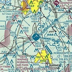
| Sectional chart |
|---|
|
CAUTION: Diagram may not be current
 Download PDF
of official airport diagram from the FAA
| Airport distance calculator |
|---|
|
|
| Sunrise and sunset |
|---|
|
Times for 17-Dec-2025
| | Local
(UTC-5) | | Zulu
(UTC) |
|---|
| Morning civil twilight | | 07:04 | | 12:04 |
| Sunrise | | 07:32 | | 12:32 |
| Sunset | | 17:30 | | 22:30 |
| Evening civil twilight | | 17:57 | | 22:57 |
|
| Current date and time |
|---|
| Zulu (UTC) | 17-Dec-2025 21:36:59 |
|---|
| Local (UTC-5) | 17-Dec-2025 16:36:59 |
|---|
|
| METAR |
|---|
| KMCN | 172053Z 17007KT 10SM FEW039 19/09 A3012 RMK AO2 SLP199 T01940094 56022
|
KWRB
6nm SE | 172055Z AUTO 21006KT 10SM CLR 20/10 A3011 RMK AO2 SLP199 T02040096 57023
|
KPXE
12nm SW | 172115Z AUTO 21008KT 10SM CLR 19/10 A3014 RMK AO2
|
|
| TAF |
|---|
| KMCN | 171739Z 1718/1818 VRB03KT P6SM SCT200 FM180000 17003KT P6SM SCT060 BKN200 FM180600 13003KT P6SM SCT025 BKN060 FM181000 11004KT P6SM BKN020 PROB30 1814/1818 4SM -SHRA SCT005 BKN010
|
KWRB
6nm SE | 171900Z 1719/1901 28010KT 9999 FEW035 SCT060 QNH3015INS BECMG 1805/1806 18004KT 9999 SCT020 BKN030 QNH3006INS TEMPO 1808/1812 3200 BR BKN020 BECMG 1815/1816 21010G15KT 9999 BKN030 OVC050 QNH3009INS BECMG 1823/1824 VRB06KT 9999 BKN025 QNH3007INS TX22/1721Z TN07/1807Z
|
|
| NOTAMs |
|---|
NOTAMs are issued by the DoD/FAA and will open in a separate window not controlled by AirNav.
|
|


