FAA INFORMATION EFFECTIVE 11 JUNE 2026
Location
| FAA Identifier: | 53A |
| Lat/Long: | 32-18-11.0280N 084-00-26.8850W
32-18.183800N 084-00.448083W
32.3030633,-84.0074681
(estimated) |
| Elevation: | 345.3 ft. / 105.2 m (surveyed) |
| Variation: | 04W (2005) |
| From city: | 1 mile E of MONTEZUMA, GA |
| Time zone: | UTC -4 (UTC -5 during Standard Time) |
| Zip code: | 31063 |
Airport Operations
| Airport use: | Open to the public |
| Activation date: | 09/1962 |
| Control tower: | no |
| ARTCC: | ATLANTA CENTER |
| FSS: | MACON FLIGHT SERVICE STATION |
| NOTAMs facility: | MCN (NOTAM-D service available) |
| Attendance: | UNATNDD |
| Wind indicator: | lighted |
| Segmented circle: | no |
| Lights: | ACTVT PAPI RWY 18 & 36; MIRL RWY 18/36 - CTAF. |
| Beacon: | white-green (lighted land airport)
Operates sunset to sunrise. |
Airport Communications
| CTAF: | 122.9 |
| ATLANTA APPROACH: | 124.2 |
| ATLANTA DEPARTURE: | 124.2 |
| WX AWOS-3 at ACJ (15 nm SW): | 128.375 (770-847-7993) |
| WX AWOS-3 at PXE (17 nm NE): | 123.825 (478-987-8768) |
| WX AWOS-3 at 6A1 (20 nm NW): | 119.525 (478-862-2966) |
- ATLANTA LARGE TRACON PROVIDES APCH/DEP SVC 0615-2300 ON FREQ 124.2/279.6 ; ATLANTA ARTCC PROVIDES APCH/DEP SVC 2300-0615 ON FREQS 134.5/360.75 (MACON RCAG).
Nearby radio navigation aids
| VOR radial/distance | | VOR name | | Freq | | Var |
|---|
| VNAr281/26.4 | | VIENNA VORTAC | | 116.50 | | 01E |
| NDB name | | Hdg/Dist | | Freq | | Var | | ID |
|---|
| LINDBERGH | | 038/9.3 | | 242 | | 04W | | LKG | .-.. -.- --. |
| CONEY | | 344/19.8 | | 400 | | 06W | | OHY | --- .... -.-- |
Airport Services
| Parking: | tiedowns |
| Airframe service: | NONE |
| Powerplant service: | NONE |
| Bottled oxygen: | NONE |
| Bulk oxygen: | NONE |
Runway Information
Runway 18/36
| Dimensions: | 5003 x 75 ft. / 1525 x 23 m |
| Surface: | asphalt, in good condition |
| Weight bearing capacity: | |
| Runway edge lights: | medium intensity |
| RUNWAY 18 | | RUNWAY 36 |
| Latitude: | 32-18.596318N | | 32-17.771290N |
| Longitude: | 084-00.443622W | | 084-00.452542W |
| Elevation: | 345.3 ft. | | 337.1 ft. |
| Traffic pattern: | left | | left |
| Runway heading: | 185 magnetic, 181 true | | 005 magnetic, 001 true |
| Displaced threshold: | 783 ft. | | no |
| Markings: | nonprecision, in good condition | | nonprecision, in good condition |
| Visual slope indicator: | 2-light PAPI on left (3.30 degrees glide path) | | 2-light PAPI on left (3.00 degrees glide path) |
| Touchdown point: | yes, no lights | | yes, no lights |
| Obstructions: | 48 ft. trees, 728 ft. from runway, 173 ft. right of centerline, 11:1 slope to clear
24:1 TO DISPLACED THRESHOLD | | 48 ft. pole, 1064 ft. from runway, 241 ft. left of centerline, 18:1 slope to clear |
Airport Ownership and Management from official FAA records
| Ownership: | Publicly-owned |
| Owner: | CITY OF MONTEZUMA
CITY HALL, P.O. BOX 388
MONTEZUMA, GA 31063
Phone 478-472-8144 |
| Manager: | MEL FULGHOM
CITY HALL, P.O. BOX 388
MONTEZUMA, GA 31063
Phone 478-472-8144 |
Additional Remarks
| - | FOR CD CTC ATLANTA APCH AT 678-364-6132, WHEN APCH CLSD CTC ATLANTA ARTCC AT 770-210-7692. |
Instrument Procedures
NOTE: All procedures below are presented as PDF files. If you need a reader for these files, you should download the free Adobe Reader.NOT FOR NAVIGATION. Please procure official charts for flight.
FAA instrument procedures published for use from 11 June 2026 at 0901Z to 09 July 2026 at 0900z.
IAPs - Instrument Approach Procedures |
|---|
| RNAV (GPS) RWY 18 | |
download (205KB) |
| RNAV (GPS) RWY 36 | |
download (210KB) |
| NOTE: Special Take-Off Minimums/Departure Procedures apply | |
download (497KB) |
Other nearby airports with instrument procedures:
KACJ - Jimmy Carter Regional Airport (15 nm SW)
KPXE - Perry-Houston County Airport (17 nm NE)
6A1 - Butler Municipal Airport (20 nm NW)
KCKF - Crisp County-Cordele Airport (22 nm SE)
KWRB - Robins Air Force Base (29 nm NE)
|
|

Road maps at:
MapQuest
Bing
Google
| Aerial photo |
|---|
WARNING: Photo may not be current or correct

Do you have a better or more recent aerial photo of Dr. C P Savage Sr. Airport that you would like to share? If so, please send us your photo.
|
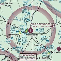
| Sectional chart |
|---|
|
| Airport distance calculator |
|---|
|
|
| Sunrise and sunset |
|---|
|
Times for 17-Jun-2026
| | Local
(UTC-4) | | Zulu
(UTC) |
|---|
| Morning civil twilight | | 06:02 | | 10:02 |
| Sunrise | | 06:30 | | 10:30 |
| Sunset | | 20:44 | | 00:44 |
| Evening civil twilight | | 21:12 | | 01:12 |
|
| Current date and time |
|---|
| Zulu (UTC) | 17-Jun-2026 10:39:59 |
|---|
| Local (UTC-4) | 17-Jun-2026 06:39:59 |
|---|
|
| METAR |
|---|
KACJ
15nm SW | 171015Z AUTO 21006KT 10SM OVC006 23/23 A2987 RMK AO2 CIG 006V008 T02290229
|
KPXE
17nm NE | 171015Z AUTO 23007KT 2 1/2SM -RA BR BKN006 OVC009 22/22 A2990 RMK AO2 VIS 2V4
|
K6A1
20nm NW | 171015Z AUTO 23005KT 5SM BR OVC004 22/22 A2989 RMK AO2 T02200218
|
KCKF
22nm SE | 170955Z AUTO 22007KT 10SM OVC006 23/23 A2991 RMK AO2 T02280225
|
KWRB
29nm NE | 171018Z AUTO 19005KT 8SM OVC009 23/22 A2986 RMK AO2 DZB0955E12 CIG 007V009 SLP111 TSNO $
|
KMCN
29nm NE | 171003Z AUTO 21006KT 7SM -RA BKN007 BKN013 OVC019 22/22 A2987 RMK AO2 RAB02 P0000 T02220222 $
|
|
| TAF |
|---|
KWRB
29nm NE | 170200Z 1702/1801 25009KT 8000 -RA FEW007 BKN025 OVC070 QNH2988INS BECMG 1703/1704 20009KT 9999 NSW FEW020 OVC100 QNH2984INS BECMG 1706/1707 18005KT 8000 -RA FEW030 OVC060 QNH2982INS BECMG 1713/1714 24009KT 9999 NSW SCT015 BKN030 QNH2983INS BECMG 1719/1720 22010G15KT 9999 SCT040 QNH2982INS TEMPO 1720/1724 22010G20KT VCTS SCT030CB TX28/1719Z TN21/1706Z LAST NO AMDS AFT 1702 NEXT 1711
|
KMCN
29nm NE | 170552Z 1706/1806 20004KT P6SM -DZ BKN008 BKN015 TEMPO 1706/1710 4SM -SHRA BKN006 FM171500 25007KT P6SM SCT008 BKN012 PROB30 1716/1719 4SM -TSRA OVC008CB FM171900 24009KT P6SM -TSRA BKN035CB FM180000 23007KT P6SM FEW100
|
|
| NOTAMs |
|---|
NOTAMs are issued by the DoD/FAA and will open in a separate window not controlled by AirNav.
|
|


