FAA INFORMATION EFFECTIVE 14 MAY 2026
Location
| FAA Identifier: | 48A |
| Lat/Long: | 32-24-02.3690N 083-16-42.2630W
32-24.039483N 083-16.704383W
32.4006581,-83.2784064
(estimated) |
| Elevation: | 377.4 ft. / 115.0 m (surveyed) |
| Variation: | 03W (1985) |
| From city: | 4 miles E of COCHRAN, GA |
| Time zone: | UTC -4 (UTC -5 during Standard Time) |
| Zip code: | 31014 |
Airport Operations
| Airport use: | Open to the public |
| Activation date: | 05/1941 |
| Control tower: | no |
| ARTCC: | ATLANTA CENTER |
| FSS: | MACON FLIGHT SERVICE STATION |
| NOTAMs facility: | MCN (NOTAM-D service available) |
| Attendance: | MON-SAT 0800-1200 |
| Wind indicator: | lighted |
| Segmented circle: | yes |
| Lights: | MIRL RWY 11/29 PRESET LOW DAWN-0800, DUSK-2100; TO ACTVT OR INCRS INTST - CTAF. |
| Beacon: | white-green (lighted land airport)
Operates sunset to sunrise. |
Airport Communications
| CTAF/UNICOM: | 122.8 |
| WX AWOS-3PT: | 120.975 (478-271-5897) |
| ATLANTA APPROACH: | 124.2 [0645-2300] |
| ATLANTA DEPARTURE: | 124.2 [0645-2300] |
| WX AWOS-3 at EZM (13 nm SE): | 119.425 (478-374-9979) |
| WX AWOS-3 at DBN (18 nm NE): | 118.425 (478-277-9051) |
- ATLANTA LARGE TRACON PROVIDES APCH/DEP SVC 0615-2300 ON FREQ 124.2/279.6; ATLANTA ARTCC PROVIDES APCH/DEP SVC 2300-0615 ON FREQS 134.5/360.75 (MACON RCAG).
Nearby radio navigation aids
| VOR radial/distance | | VOR name | | Freq | | Var |
|---|
| VNAr044/15.8 | | VIENNA VORTAC | | 116.50 | | 01E |
| DBNr252/24.7 | | DUBLIN VORTAC | | 113.10 | | 05W |
| NDB name | | Hdg/Dist | | Freq | | Var | | ID |
|---|
| EASTMAN | | 343/17.3 | | 366 | | 04W | | EZM | . --.. -- |
| CONEY | | 057/38.2 | | 400 | | 06W | | OHY | --- .... -.-- |
Airport Services
| Fuel available: | 100LL
100LL:24HR FUEL SELF SERV W/MAJOR CREDIT CARD. |
| Parking: | tiedowns |
| Airframe service: | MINOR |
| Powerplant service: | MINOR |
| Bottled oxygen: | NONE |
| Bulk oxygen: | NONE |
Runway Information
Runway 11/29
| Dimensions: | 4400 x 75 ft. / 1341 x 23 m |
| Surface: | asphalt, in good condition |
| Runway edge lights: | medium intensity |
| RUNWAY 11 | | RUNWAY 29 |
| Latitude: | 32-24.184432N | | 32-24.008352N |
| Longitude: | 083-17.227708W | | 083-16.397957W |
| Elevation: | 377.4 ft. | | 333.6 ft. |
| Traffic pattern: | left | | left |
| Runway heading: | 107 magnetic, 104 true | | 287 magnetic, 284 true |
| Markings: | nonprecision, in good condition | | nonprecision, in good condition |
| Visual slope indicator: | 2-light PAPI on left (3.25 degrees glide path) | | 2-light PAPI on left (3.00 degrees glide path) |
| Touchdown point: | yes, no lights | | yes, no lights |
| Obstructions: | 65 ft. trees, 1585 ft. from runway, 398 ft. left of centerline, 21:1 slope to clear | | 68 ft. trees, 2363 ft. from runway, 415 ft. right of centerline, 31:1 slope to clear |
Runway 5/23
| Dimensions: | 3202 x 50 ft. / 976 x 15 m |
| Surface: | asphalt, in poor condition
RWY 05/23 PAVEMENT IN POOR COND. |
| Weight bearing capacity: | |
| Operational restrictions: | RWY 5/23 IS DAYLIGHT USE ONLY. |
| RUNWAY 5 | | RUNWAY 23 |
| Latitude: | 32-23.778307N | | 32-24.144202N |
| Longitude: | 083-16.779688W | | 083-16.330992W |
| Elevation: | 324.2 ft. | | 332.5 ft. |
| Traffic pattern: | left | | left |
| Runway heading: | 049 magnetic, 046 true | | 229 magnetic, 226 true |
| Displaced threshold: | no | | 140 ft. |
| Declared distances: | | | TORA:3202 TODA:3202 ASDA:3202 LDA:3062 |
| Markings: | nonprecision, in good condition | | nonprecision, in good condition |
| Touchdown point: | yes, no lights | | yes, no lights |
| Obstructions: | 44 ft. trees, 720 ft. from runway, 88 ft. right of centerline, 11:1 slope to clear | | 40 ft. trees, 1143 ft. from runway, 27 ft. left of centerline, 23:1 slope to clear |
Airport Ownership and Management from official FAA records
| Ownership: | Publicly-owned |
| Owner: | CITY OF COCHRAN
CITY HALL, PO BOX 8
COCHRAN, GA 31014
Phone 478-934-6346 |
| Manager: | LISA EISELE
112 WEST DYKES STREET
COCHRAN, GA 31014
Phone 478-934-6346
ALT PHONE 478-230-7843 |
Additional Remarks
| - | NON STD TURNAROUNDS, INADEQUATE SEPARATION RUNWAY 05/23. |
| - | FOR CD CTC ATLANTA APCH AT 678-364-6132, WHEN APCH CLSD CTC ATLANTA ARTCC AT 770-210-7692. |
Instrument Procedures
NOTE: All procedures below are presented as PDF files. If you need a reader for these files, you should download the free Adobe Reader.NOT FOR NAVIGATION. Please procure official charts for flight.
FAA instrument procedures published for use from 14 May 2026 at 0901Z to 11 June 2026 at 0900Z.
IAPs - Instrument Approach Procedures |
|---|
| RNAV (GPS) RWY 29 | |
download (206KB) |
| NOTE: Special Alternate Minimums apply **CHANGED** | |
download (158KB) |
| NOTE: Special Take-Off Minimums/Departure Procedures apply | |
download (504KB) |
Other nearby airports with instrument procedures:
KEZM - Heart of Georgia Regional Airport (13 nm SE)
KDBN - W H 'Bud' Barron Airport (18 nm NE)
KWRB - Robins Air Force Base (21 nm NW)
KPXE - Perry-Houston County Airport (26 nm W)
KMCN - Middle Georgia Regional Airport (26 nm NW)
|
|

Road maps at:
MapQuest
Bing
Google
| Aerial photo |
|---|
WARNING: Photo may not be current or correct
 Taken in the Summer of 2013
looking northeast.
Taken in the Summer of 2013
looking northeast.
Do you have a better or more recent aerial photo of Cochran Airport that you would like to share? If so, please send us your photo.
|
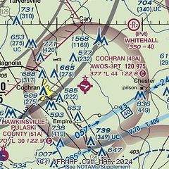
| Sectional chart |
|---|
|
| Airport distance calculator |
|---|
|
|
| Sunrise and sunset |
|---|
|
Times for 22-May-2026
| | Local
(UTC-4) | | Zulu
(UTC) |
|---|
| Morning civil twilight | | 06:04 | | 10:04 |
| Sunrise | | 06:32 | | 10:32 |
| Sunset | | 20:28 | | 00:28 |
| Evening civil twilight | | 20:55 | | 00:55 |
|
| Current date and time |
|---|
| Zulu (UTC) | 22-May-2026 06:08:02 |
|---|
| Local (UTC-4) | 22-May-2026 02:08:02 |
|---|
|
| METAR |
|---|
| K48A | 220555Z AUTO 13004KT 10SM SCT120 23/20 A3003 RMK AO2 T02320201 10296 20231
|
KEZM
13nm SE | 220555Z AUTO 15003KT 10SM CLR 22/20 A3005 RMK AO2
|
KDBN
18nm NE | 220555Z AUTO 15003KT 10SM CLR 24/22 A3003 RMK AO2 60000 T02370216 10282 20229 57003
|
|
| TAF |
|---|
KWRB
20nm NW | 212340Z 2123/2301 16009KT 9999 VCTS BKN040CB QNH2995INS TEMPO 2200/2203 23015G25KT 8000 -SHRA VCTS BKN030CB BECMG 2202/2203 15006KT 9999 NSW BKN030 QNH2998INS BECMG 2208/2209 17006KT 9999 SCT045 BKN120 QNH2997INS BECMG 2218/2219 16009KT 9999 VCTS BKN035CB QNH2996INS TEMPO 2219/2221 23020G35KT 3200 -TSRA BKN025CB BECMG 2221/2222 15009KT 9999 -SHRA OVC100 QNH2996INS TX31/2123Z TN20/2210Z
|
|
| NOTAMs |
|---|
NOTAMs are issued by the DoD/FAA and will open in a separate window not controlled by AirNav.
|
|


