FAA INFORMATION EFFECTIVE 14 MAY 2026
Location
| FAA Identifier: | DBN |
| Lat/Long: | 32-33-53.0000N 082-59-05.9000W
32-33.883333N 082-59.098333W
32.5647222,-82.9849722
(estimated) |
| Elevation: | 311 ft. / 94.8 m (surveyed) |
| Variation: | 04W (2000) |
| From city: | 3 miles NW of DUBLIN, GA |
| Time zone: | UTC -4 (UTC -5 during Standard Time) |
| Zip code: | 31021 |
Airport Operations
| Airport use: | Open to the public |
| Activation date: | 02/1944 |
| Control tower: | no |
| ARTCC: | ATLANTA CENTER |
| FSS: | MACON FLIGHT SERVICE STATION |
| NOTAMs facility: | MCN (NOTAM-D service available) |
| Attendance: | MON-FRI 0800-1700
ARPT PHONE 478-275-0029. |
| Wind indicator: | yes |
| Segmented circle: | yes |
| Lights: | ACTVT MALSR RWY 02; PAPI RWY 02 & 20 - CTAF. HIRL RWY 02/20 OPER CONT DUSK-2200; AFTER 2200 ACTVT - CTAF. |
| Beacon: | white-green (lighted land airport)
Operates sunset to sunrise. |
Airport Communications
| CTAF/UNICOM: | 122.7 |
| WX AWOS-3: | 118.425 (478-277-9051) |
| ATLANTA APPROACH: | 124.2 |
| ATLANTA DEPARTURE: | 124.2 |
| WX AWOS-3PT at 48A (18 nm SW): | 120.975 (478-271-5897) |
- APCH/DEP SVC PRVDD BY ATLANTA LARGE TRACON 0615-2300; APCH/DEP SVC PRVDD BY ATLANTA ARTCC 2300-0615 ON FREQS 123.95/269.3 (MACON RCAG).
Nearby radio navigation aids
| VOR radial/distance | | VOR name | | Freq | | Var |
|---|
| DBNr276/7.8 | | DUBLIN VORTAC | | 113.10 | | 05W |
| VNAr050/33.4 | | VIENNA VORTAC | | 116.50 | | 01E |
| NDB name | | Hdg/Dist | | Freq | | Var | | ID |
|---|
| EASTMAN | | 022/27.4 | | 366 | | 04W | | EZM | . --.. -- |
Airport Services
| Fuel available: | 100LL JET-A+
100LL:SELF-SERVICE FUEL AVBL 24 HRS WITH CREDIT CARD. |
| Parking: | tiedowns |
| Airframe service: | MAJOR |
| Powerplant service: | MAJOR |
| Bottled oxygen: | NONE |
| Bulk oxygen: | NONE |
Runway Information
Runway 2/20
| Dimensions: | 6501 x 150 ft. / 1982 x 46 m |
| Surface: | asphalt, in good condition |
| Weight bearing capacity: | | Single wheel: | 30.0 | | Double wheel: | 53.0 |
|
| Runway edge lights: | high intensity |
| RUNWAY 2 | | RUNWAY 20 |
| Latitude: | 32-33.437585N | | 32-34.466535N |
| Longitude: | 082-59.094992W | | 082-58.739437W |
| Elevation: | 290.9 ft. | | 311.0 ft. |
| Traffic pattern: | left | | left |
| Runway heading: | 020 magnetic, 016 true | | 200 magnetic, 196 true |
| Displaced threshold: | no | | 489 ft. |
| Declared distances: | TORA:6300 TODA:6300 ASDA:6300 LDA:6300 | | TORA:6500 TODA:6500 ASDA:6000 LDA:6000 |
| Markings: | precision, in good condition | | precision, in good condition |
| Visual slope indicator: | 2-light PAPI on left (3.00 degrees glide path) | | 2-light PAPI on left (3.00 degrees glide path) |
| Approach lights: | MALSR: 1,400 foot medium intensity approach lighting system with runway alignment indicator lights | | |
| Touchdown point: | yes, no lights | | yes, no lights |
| Instrument approach: | ILS/DME | | |
| Obstructions: | 64 ft. trees, 1419 ft. from runway, 602 ft. right of centerline, 19:1 slope to clear | | 15 ft. road, 201 ft. from runway, 36 ft. left of centerline
CONTROLLING OBSTRUCTION EXCEEDS A 45 DEGREE SLOPE |
Runway 14/32
| Dimensions: | 5171 x 100 ft. / 1576 x 30 m |
| Surface: | asphalt, in fair condition |
| Weight bearing capacity: | | Single wheel: | 28.0 | | Double wheel: | 44.0 |
|
| RUNWAY 14 | | RUNWAY 32 |
| Latitude: | 32-34.105045N | | 32-33.488100N |
| Longitude: | 082-59.674455W | | 082-58.979412W |
| Elevation: | 304.2 ft. | | 290.8 ft. |
| Traffic pattern: | left | | left |
| Runway heading: | 140 magnetic, 136 true | | 320 magnetic, 316 true |
| Declared distances: | TORA:5171 TODA:5171 ASDA:5171 LDA:5171 | | TORA:5171 TODA:5171 ASDA:5171 LDA:5171 |
| Markings: | basic, in good condition | | basic, in good condition |
| Touchdown point: | yes, no lights | | yes, no lights |
| Obstructions: | 64 ft. trees, 1445 ft. from runway, 189 ft. both sides of centerline, 19:1 slope to clear | | 98 ft. trees, 1604 ft. from runway, 194 ft. both sides of centerline, 14:1 slope to clear |
Airport Ownership and Management from official FAA records
| Ownership: | Publicly-owned |
| Owner: | LAURENS COUNTY
P O BOX 2011
DUBLIN, GA 31040
Phone 478-272-4755 |
| Manager: | BRYAN ROGERS, COUNTY ADM
PO BOX 2011
DUBLIN, GA 31040
Phone 478-272-4755 |
Additional Remarks
| - | FOR APCH/DEP SVC CTC ATLANTA APCH AT 678-364-6131. WHEN ATLANTA APCH UNAVBL CTC ATLANTA ARTCC AT 770-210-7692. |
| - | FOR CD IF UNA TO CTC ON FSS FREQ, CTC ATLANTA APCH AT 678-364-6132, WHEN ATCT CLSD CTC ATLANTA ARTCC AT 770-210-7692. |
Instrument Procedures
NOTE: All procedures below are presented as PDF files. If you need a reader for these files, you should download the free Adobe Reader.NOT FOR NAVIGATION. Please procure official charts for flight.
FAA instrument procedures published for use from 14 May 2026 at 0901Z to 11 June 2026 at 0900Z.
IAPs - Instrument Approach Procedures |
|---|
| ILS OR LOC RWY 02 | |
download (229KB) |
| RNAV (GPS) RWY 02 | |
download (271KB) |
| RNAV (GPS) RWY 20 | |
download (247KB) |
| NOTE: Special Alternate Minimums apply | |
download (156KB) |
| NOTE: Special Take-Off Minimums/Departure Procedures apply | |
download (189KB) |
Other nearby airports with instrument procedures:
48A - Cochran Airport (18 nm SW)
KEZM - Heart of Georgia Regional Airport (22 nm S)
KOKZ - Kaolin Field Airport (25 nm N)
KMQW - Telfair-Wheeler Airport (29 nm S)
KWRB - Robins Air Force Base (31 nm W)
|
|

Road maps at:
MapQuest
Bing
Google
| Aerial photo |
|---|
WARNING: Photo may not be current or correct
 Photo by Dave Wolf
Photo taken 26-May-2008
Shot departing from Runway 20, exiting traffic pattern
Photo by Dave Wolf
Photo taken 26-May-2008
Shot departing from Runway 20, exiting traffic pattern
Do you have a better or more recent aerial photo of W H 'Bud' Barron Airport that you would like to share? If so, please send us your photo.
|
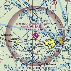
| Sectional chart |
|---|
|
CAUTION: Diagram may not be current

| Airport distance calculator |
|---|
|
|
| Sunrise and sunset |
|---|
|
Times for 08-Jun-2026
| | Local
(UTC-4) | | Zulu
(UTC) |
|---|
| Morning civil twilight | | 05:57 | | 09:57 |
| Sunrise | | 06:25 | | 10:25 |
| Sunset | | 20:37 | | 00:37 |
| Evening civil twilight | | 21:05 | | 01:05 |
|
| Current date and time |
|---|
| Zulu (UTC) | 08-Jun-2026 05:39:57 |
|---|
| Local (UTC-4) | 08-Jun-2026 01:39:57 |
|---|
|
| METAR |
|---|
| KDBN | 080515Z AUTO 00000KT 10SM OVC050 24/24 A3007 RMK AO2 T02440244
|
K48A
18nm SW | 080515Z AUTO 00000KT 10SM -DZ SCT100 SCT120 24/23 A3007 RMK AO2 T02430234
|
|
| TAF |
|---|
KWRB
30nm W | 080300Z 0803/0909 VRB06KT 9999 SCT050 BKN090 BKN120 QNH3000INS BECMG 0809/0810 VRB06KT 9999 SCT050 BKN090 QNH3003INS TEMPO 0818/0820 -SHRA VCTS BKN050CB BECMG 0820/0821 09006KT 8000 -SHRA BKN040 OVC080 QNH3005INS BECMG 0903/0904 14006KT 9999 -RA SCT040 BKN060 BKN140 QNH3010INS TX30/0819Z TN22/0810Z
|
KMCN
34nm W | 080249Z 0803/0824 VRB03KT P6SM SCT050 BKN150 FM081100 00000KT 6SM BR SCT008 OVC025 FM081400 00000KT P6SM VCSH BKN012 OVC025 PROB30 0815/0821 4SM -TSRA BKN012CB FM082100 VRB03KT P6SM VCSH BKN025
|
|
| NOTAMs |
|---|
NOTAMs are issued by the DoD/FAA and will open in a separate window not controlled by AirNav.
|
|


