FAA INFORMATION EFFECTIVE 09 JULY 2026
Location
| FAA Identifier: | MQY |
| Lat/Long: | 36-00-32.2930N 086-31-12.3230W
36-00.538217N 086-31.205383W
36.0089703,-86.5200897
(estimated) |
| Elevation: | 543 ft. / 165.5 m (surveyed) |
| Variation: | 02W (1995) |
| From city: | 2 miles N of SMYRNA, TN |
| Time zone: | UTC -5 (UTC -6 during Standard Time) |
| Zip code: | 37167 |
Airport Operations
| Airport use: | Open to the public |
| Activation date: | 10/1942 |
| Control tower: | yes |
| ARTCC: | MEMPHIS CENTER |
| FSS: | NASHVILLE FLIGHT SERVICE STATION |
| NOTAMs facility: | MQY (NOTAM-D service available) |
| Attendance: | CONTINUOUS |
| Pattern altitude: | 1500 ft. MSL
TPA: 457 FT AGL HEL, 957 FT AGL LIGHT ACFT, 1457 FT AGL TURBOPROP/JET. |
| Wind indicator: | lighted |
| Segmented circle: | yes |
| Lights: | ACTVT MALSR RWY 32; REIL RWY 14; MIRL RWY 01/19; HIRL RWY 14/32 - CTAF. PAPI RWY 01, 14, 19 & 32 OPR CONSLY. |
| Beacon: | white-green (lighted land airport)
Operates sunset to sunrise. |
| Fire and rescue: | ARFF index A |
Airport Communications
| CTAF: | 118.5 |
| UNICOM: | 122.95 |
| WX AWOS-3PT: | 119.125 (615-223-7716) |
| SMYRNA GROUND: | 121.4 [0700-2200 MON-FRI, 0700-1900 SAT-SUN] |
| SMYRNA TOWER: | 118.5 233.1 [0700-2200 MON-FRI, 0700-1900 SAT-SUN] |
| NASHVILLE APPROACH: | 118.4 |
| NASHVILLE DEPARTURE: | 118.4 |
| CLEARANCE DELIVERY: | 121.4 |
| NG OPS: | 149.8 373.9 41.5 |
| WX ASOS at BNA (10 nm NW): | PHONE 629-236-5115 |
| WX AWOS-3 at MBT (10 nm SE): | 133.975 (615-849-2622) |
| WX AWOS-3 at M54 (15 nm NE): | 118.325 (615-444-5778) |
Nearby radio navigation aids
| VOR radial/distance | | VOR name | | Freq | | Var |
|---|
| BNAr136/11.1 | | NASHVILLE VORTAC | | 114.10 | | 02W |
| SYIr353/27.1 | | SHELBYVILLE VOR/DME | | 113.55 | | 01W |
Airport Services
| Fuel available: | 100LL JET-A
A:C615-220-2957 OR C615-459-3337. |
| Parking: | hangars and tiedowns |
| Airframe service: | MAJOR |
| Powerplant service: | MAJOR |
| Bottled oxygen: | LOW |
| Bulk oxygen: | HIGH/LOW |
Runway Information
Runway 14/32
| Dimensions: | 8038 x 150 ft. / 2450 x 46 m |
| Surface: | asphalt/grooved, in good condition |
| Weight bearing capacity: | | PCN 454/F/B/X/T | | Single wheel: | 95.0 | | Double wheel: | 160.0 | | Double tandem: | 175.0 | | Dual double tandem: | 250.0 |
|
| Runway edge lights: | high intensity |
| RUNWAY 14 | | RUNWAY 32 |
| Latitude: | 36-01.070182N | | 36-00.068267N |
| Longitude: | 086-31.723107W | | 086-30.656265W |
| Elevation: | 543.0 ft. | | 517.3 ft. |
| Traffic pattern: | left | | left |
| Runway heading: | 141 magnetic, 139 true | | 321 magnetic, 319 true |
| Markings: | precision, in good condition | | precision, in good condition |
| Visual slope indicator: | 4-light PAPI on left (3.00 degrees glide path) | | 4-light PAPI on left (3.00 degrees glide path) |
| Approach lights: | | | MALSR: 1,400 foot medium intensity approach lighting system with runway alignment indicator lights |
| Runway end identifier lights: | yes | | yes |
| Touchdown point: | yes, no lights | | yes, no lights |
| Instrument approach: | | | ILS |
| Obstructions: | 35 ft. tree, 1500 ft. from runway, 485 ft. right of centerline, 37:1 slope to clear | | none |
Runway 1/19
| Dimensions: | 5546 x 100 ft. / 1690 x 30 m |
| Surface: | asphalt/grooved, in excellent condition |
| Weight bearing capacity: | | PCN 520/F/D/X/T | | Single wheel: | 40.0 | | Double wheel: | 100.0 | | Double tandem: | 160.0 | | Dual double tandem: | 270.0 |
|
| Runway edge lights: | medium intensity |
| RUNWAY 1 | | RUNWAY 19 |
| Latitude: | 36-00.037370N | | 36-00.949128N |
| Longitude: | 086-31.268730W | | 086-31.187665W |
| Elevation: | 519.2 ft. | | 521.4 ft. |
| Traffic pattern: | left | | left |
| Runway heading: | 006 magnetic, 004 true | | 186 magnetic, 184 true |
| Markings: | nonprecision, in good condition | | nonprecision, in good condition |
| Visual slope indicator: | 4-light PAPI on left (3.50 degrees glide path) | | 4-light PAPI on left (3.00 degrees glide path) |
| Runway end identifier lights: | yes | | yes |
| Touchdown point: | yes, no lights | | yes, no lights |
| Obstructions: | 74 ft. tree, 1800 ft. from runway, 143 ft. right of centerline, 21:1 slope to clear | | none |
Helipad H1
| Dimensions: | 40 x 40 ft. / 12 x 12 m |
| Surface: | concrete, in fair condition |
| Runway edge lights: | PERI
OTS INDEFLY. MIL: ACTVT HELI PERIMETER LGT - AMGR. |
| Operational restrictions: | CLSD INDEFLY. |
| Latitude: | 36-00.593333N | | |
| Longitude: | 086-30.652667W | | |
| Elevation: | 512.0 ft. | | |
| Traffic pattern: | left | | left |
| Markings: | basic, in poor condition | | |
Airport Ownership and Management from official FAA records
| Ownership: | Publicly-owned |
| Owner: | SMYRNA/RUTHERFORD ARPT AUTH
278 DOUG WARPOOLE RD.
SMYRNA, TN 37167
Phone 615-459-2651 |
| Manager: | EVAN LESTER
278 DOUG WARPOOLE RD.
SMYRNA, TN 37167
Phone 615-459-2651 |
Additional Remarks
| - | NASHVILLE INTL TFC TRANSITS SMYRNA TFC AREA AT 2500 FT MSL & ABV. |
| - | FOR CD WHEN ATCT CLSD, CTC NASHVILLE APCH AT 615-695-4522. |
| - | ANG BASE OPS 0630-1600 MON-FRI; PPR - D683-3611. |
| - | 24 HR PPR OVR 30 PAX - AMGR. |
| - | TWY J SOUTH OF TWY A LTD TO 65000 LB. |
| - | TWY K LTD TO 65000 LB. |
| - | CLASS D SVC 1300-0400Z MON-FRI. |
Instrument Procedures
NOTE: All procedures below are presented as PDF files. If you need a reader for these files, you should download the free Adobe Reader.NOT FOR NAVIGATION. Please procure official charts for flight.
FAA instrument procedures published for use from 09 July 2026 at 0901Z to 06 August 2026 at 0900Z.
IAPs - Instrument Approach Procedures |
|---|
| ILS OR LOC RWY 32 | |
download (270KB) |
| RNAV (GPS) RWY 01 | |
download (231KB) |
| RNAV (GPS) RWY 14 | |
download (219KB) |
| RNAV (GPS) RWY 19 | |
download (238KB) |
| RNAV (GPS) RWY 32 | |
download (259KB) |
| NOTE: Special Alternate Minimums apply | |
download (162KB) |
| NOTE: Special Take-Off Minimums/Departure Procedures apply | |
download (362KB) |
Other nearby airports with instrument procedures:
KBNA - Nashville International Airport (10 nm NW)
KMBT - Murfreesboro Municipal Airport (10 nm SE)
M54 - Lebanon Municipal Airport (15 nm NE)
KJWN - John C Tune Airport (21 nm NW)
KXNX - Music City Executive Airport (23 nm N)
|
|

Road maps at:
MapQuest
Bing
Google
| Aerial photo |
|---|
WARNING: Photo may not be current or correct
 Photo by Eve Cascella
Photo taken 14-Sep-2010
looking north.
Photo by Eve Cascella
Photo taken 14-Sep-2010
looking north.
Do you have a better or more recent aerial photo of Smyrna Airport that you would like to share? If so, please send us your photo.
|
| Sectional chart |
|---|
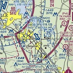
|
CAUTION: Diagram may not be current
 Download PDF
of official airport diagram from the FAA
| Airport distance calculator |
|---|
|
|
| Sunrise and sunset |
|---|
|
Times for 24-Jul-2026
| | Local
(UTC-5) | | Zulu
(UTC) |
|---|
| Morning civil twilight | | 05:19 | | 10:19 |
| Sunrise | | 05:48 | | 10:48 |
| Sunset | | 19:57 | | 00:57 |
| Evening civil twilight | | 20:26 | | 01:26 |
|
| Current date and time |
|---|
| Zulu (UTC) | 24-Jul-2026 12:48:52 |
|---|
| Local (UTC-5) | 24-Jul-2026 07:48:52 |
|---|
|
| METAR |
|---|
| KMQY | 241156Z 00000KT 10SM CLR 21/19 A3012 RMK AO2 SLP202 70001 T02060194 10206 20194 53008
|
KBNA
10nm NW | 241153Z 00000KT 10SM FEW140 BKN190 21/16 A3011 RMK AO2 SLP190 7//// T02110156 10217 20194 53007 $
|
KMBT
10nm SE | 241235Z AUTO 00000KT 10SM CLR 21/18 A3009 RMK A01
|
KM54
15nm NE | 241235Z AUTO 35003KT 10SM CLR 20/18 A3009 RMK A01
|
|
| TAF |
|---|
| KMQY | 241120Z 2412/2512 VRB04KT P6SM SCT060 BKN250 FM241900 33005KT P6SM FEW070 SCT200 FM250400 00000KT P6SM SCT120
|
KBNA
10nm NW | 241120Z 2412/2518 00000KT P6SM SCT120 BKN250 FM242000 35005KT P6SM BKN250 FM250300 00000KT P6SM BKN200 FM251600 22004KT P6SM OVC100
|
|
| NOTAMs |
|---|
NOTAMs are issued by the DoD/FAA and will open in a separate window not controlled by AirNav.
|
|


