FAA INFORMATION EFFECTIVE 11 JUNE 2026
Location
| FAA Identifier: | MVE |
| Lat/Long: | 44-58-09.1000N 095-42-37.4000W
44-58.151667N 095-42.623333W
44.9691944,-95.7103889
(estimated) |
| Elevation: | 1034 ft. / 315.2 m (surveyed) |
| Variation: | 02E (2015) |
| From city: | 2 miles N of MONTEVIDEO, MN |
| Time zone: | UTC -5 (UTC -6 during Standard Time) |
| Zip code: | 56265 |
Airport Operations
| Airport use: | Open to the public |
| Activation date: | 09/1945 |
| Control tower: | no |
| ARTCC: | MINNEAPOLIS CENTER |
| FSS: | PRINCETON FLIGHT SERVICE STATION |
| NOTAMs facility: | MVE (NOTAM-D service available) |
| Attendance: | MON-FRI 0800-1700 |
| Wind indicator: | lighted |
| Segmented circle: | no |
| Lights: | MIRL PRESET TO LOW SS-SR. TO INCR INTSY AND ACTVT REIL RY 14/32 & PAPI RY 14/32 - CTAF. |
| Beacon: | white-green (lighted land airport)
Operates sunset to sunrise. |
Airport Communications
| CTAF/UNICOM: | 122.8 |
| WX AWOS-3PT: | 119.675 (320-269-5830) |
| WX AWOS-3 at GDB (15 nm SE): | 120.1 (320-564-9388) |
| WX AWOS-3 at DXX (20 nm W): | 118.975 (320-598-3863) |
| WX AWOS-3PT at AQP (20 nm NW): | 118.5 (320-289-1265) |
- APCH/DEP SVC PRVDD BY MINNEAPOLIS ARTCC ON FREQS 125.5/323.1 (DARWIN RCAG).
Nearby radio navigation aids
| VOR radial/distance | | VOR name | | Freq | | Var |
|---|
| MVE at field | | MONTEVIDEO VOR/DME | | 111.60 | | 05E |
| BDHr246/26.3 | | WILLMAR VOR/DME | | 113.70 | | 04E |
| MMLr004/31.6 | | MARSHALL VOR/DME | | 111.00 | | 05E |
| MOXr158/37.4 | | MORRIS VOR/DME | | 109.60 | | 05E |
| RWFr314/39.0 | | REDWOOD FALLS VOR/DME | | 113.30 | | 07E |
Airport Services
| Fuel available: | 100LL
100LL:FUEL SELF SVC 24 HRS WITH CREDIT CARD. |
| Parking: | hangars and tiedowns |
| Airframe service: | MAJOR |
| Powerplant service: | MAJOR |
| Bottled oxygen: | NONE |
| Bulk oxygen: | NONE |
Runway Information
Runway 14/32
| Dimensions: | 3999 x 75 ft. / 1219 x 23 m |
| Surface: | asphalt, in fair condition |
| Weight bearing capacity: | |
| Runway edge lights: | medium intensity |
| RUNWAY 14 | | RUNWAY 32 |
| Latitude: | 44-58.358693N | | 44-57.835072N |
| Longitude: | 095-42.866057W | | 095-42.304772W |
| Elevation: | 1034.0 ft. | | 1019.6 ft. |
| Traffic pattern: | left | | left |
| Runway heading: | 141 magnetic, 143 true | | 321 magnetic, 323 true |
| Markings: | nonprecision, in good condition | | nonprecision, in good condition |
| Visual slope indicator: | 4-light PAPI on left (3.00 degrees glide path) | | 4-light PAPI on left (3.00 degrees glide path) |
| Runway end identifier lights: | yes | | yes |
| Touchdown point: | yes, no lights | | yes, no lights |
Runway 3/21
| Dimensions: | 2361 x 165 ft. / 720 x 50 m |
| Surface: | turf, in good condition |
| Runway edge markings: | RY 03/21 THRS & EDGES MARKED WITH YELLOW CONES. |
| RUNWAY 3 | | RUNWAY 21 |
| Latitude: | 44-58.094255N | | 44-58.396735N |
| Longitude: | 095-42.859613W | | 095-42.516113W |
| Elevation: | 1034.0 ft. | | 1021.9 ft. |
| Traffic pattern: | left | | left |
| Runway heading: | 036 magnetic, 038 true | | 216 magnetic, 218 true |
| Touchdown point: | yes, no lights | | yes, no lights |
| Obstructions: | none | | 7 ft. brush, 133 ft. from runway, 138 ft. right of centerline, 19:1 slope to clear |
Airport Ownership and Management from official FAA records
| Ownership: | Publicly-owned |
| Owner: | CITY OF MONTEVIDEO
103 CANTON AVE;, PO BOX 517
MONTEVIDEO, MN 56265
Phone 320-269-6575
AND CHIPPEWA COUNTY. |
| Manager: | MARK BORGERSON
P.O. BOX 154, 1902 BENSON RD
MONTEVIDEO, MN 56265
Phone 320-269-4829 |
Additional Remarks
| - | RWY 03/21 NOT PLOWED WINTER MONTHS. |
| - | ULTRALIGHTS ON AND INVOF ARPT. |
| - | FOR CD IF UNA TO CTC ON FSS FREQ, CTC MINNEAPOLIS ARTCC AT 651-463-5588. |
Instrument Procedures
NOTE: All procedures below are presented as PDF files. If you need a reader for these files, you should download the free Adobe Reader.NOT FOR NAVIGATION. Please procure official charts for flight.
FAA instrument procedures published for use from 11 June 2026 at 0901Z to 09 July 2026 at 0900z.
IAPs - Instrument Approach Procedures |
|---|
| RNAV (GPS) RWY 14 **CHANGED** | |
download (250KB) |
| RNAV (GPS) RWY 32 **CHANGED** | |
download (250KB) |
| NOTE: Special Alternate Minimums apply | |
download (47KB) |
| NOTE: Special Take-Off Minimums/Departure Procedures apply | |
download (228KB) |
Other nearby airports with instrument procedures:
KGDB - Granite Falls Municipal Airport/Lenzen-Roe-Fagen Memorial Field (15 nm SE)
KDXX - Lac Qui Parle County Airport (20 nm W)
KAQP - Appleton Municipal Airport (20 nm NW)
KBBB - Benson Municipal Airport (22 nm N)
KBDH - Willmar Municipal Airport-John L Rice Field (26 nm E)
|
|

Road maps at:
MapQuest
Bing
Google
| Aerial photo |
|---|

|
| Sectional chart |
|---|
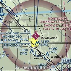
|
| Airport distance calculator |
|---|
|
|
| Sunrise and sunset |
|---|
|
Times for 14-Jun-2026
| | Local
(UTC-5) | | Zulu
(UTC) |
|---|
| Morning civil twilight | | 04:59 | | 09:59 |
| Sunrise | | 05:37 | | 10:37 |
| Sunset | | 21:10 | | 02:10 |
| Evening civil twilight | | 21:47 | | 02:47 |
|
| Current date and time |
|---|
| Zulu (UTC) | 14-Jun-2026 09:58:26 |
|---|
| Local (UTC-5) | 14-Jun-2026 04:58:26 |
|---|
|
| METAR |
|---|
| KMVE | 140955Z AUTO 34013G17KT 10SM CLR 11/07 A3006 RMK AO2
|
KGDB
15nm SE | 140935Z AUTO 32011G14KT 10SM SCT060 14/07 A3006 RMK AO2 T01360071
|
KDXX
19nm W | 140955Z AUTO 34015G21KT 10SM CLR 11/05 A3009 RMK AO2
|
|
| TAF |
|---|
KRWF
37nm SE | 140520Z 1406/1506 30008KT P6SM SKC FM141400 32012KT P6SM SKC FM141600 31013G21KT P6SM SKC FM150100 31008KT P6SM SKC
|
|
| NOTAMs |
|---|
NOTAMs are issued by the DoD/FAA and will open in a separate window not controlled by AirNav.
|
|

