FAA INFORMATION EFFECTIVE 14 MAY 2026
Location
| FAA Identifier: | NBG |
| Lat/Long: | 29-49-37.9728N 090-01-35.7239W
29-49.632880N 090-01.595398W
29.8272147,-90.0265900
(estimated) |
| Elevation: | 2.1 ft. / 1 m (estimated) |
| Variation: | 00E (2010) |
| From city: | 3 miles S of NEW ORLEANS, LA |
| Time zone: | UTC -5 (UTC -6 during Standard Time) |
| Zip code: | 70037 |
Airport Operations
| Airport use: | Private use. Permission required prior to landing |
| Activation date: | 04/1940 |
| Control tower: | yes |
| ARTCC: | HOUSTON CENTER |
| FSS: | DE RIDDER FLIGHT SERVICE STATION |
| NOTAMs facility: | NBG (NOTAM-D service available) |
| Attendance: | SAT-SUN 1600-0000Z++, ALL MON-FRI 1300-0500Z++
CLSD HOL EXC BY NOTAM.
CLSD HOL EXCEPT BY NOTAM. |
| Pattern altitude: | TFC PAT: OVERHEAD BREAK ALT 1500'. PAT ALT 1000'. |
| Segmented circle: | no |
| Lights: | PCL 123.8 OR 340.2. |
| Beacon: | white-white-green (lighted military airport)
Operates sunset to sunrise. |
| International operations: | international airport of entry |
Airport Communications
| ATIS: | 279.55 |
| NAVY NEW ORLEANS GROUND: | 121.6 270.35 [1300-0500Z++ MON-FRI, 1500-2300Z++ SAT,SUN; CLSD HOL EXC BY NOTAM.] |
| NAVY NEW ORLEANS TOWER: | 123.8 340.2 [1300-0500Z++ MON-FRI, 1500-2300Z++ SAT,SUN; CLSD HOL EXC BY NOTAM.] |
| NEW ORLEANS APPROACH: | 123.85 |
| NEW ORLEANS DEPARTURE: | 123.85 |
| CLEARANCE DELIVERY: | 128.35 263.0 |
| BASE OPS: | 289.6 |
| CG OPS: | 381.8 5696 8984 |
| EMERG: | 121.5 243.0 |
| MNSTR STAR: | 133.15 ;EAST |
| PMSV METRO: | 265.8 |
| WX ASOS at NEW (13 nm N): | PHONE 504-245-4366 |
| WX ASOS at MSY (16 nm NW): | PHONE 504-471-4486 |
- ILS UNMONITORED DURING UNMANNED TOWER OPERATIONS.
- FREQS 381.8X, 5696X & 8984 AVBL ON REQ THRU COAST GUARD RDO NEW ORLEANS - NMG.
Nearby radio navigation aids
| VOR radial/distance | | VOR name | | Freq | | Var |
|---|
| HRVr220/1.8 | | HARVEY VORTAC | | 114.10 | | 02E |
| RQRr116/33.1 | | RESERVE VOR/DME | | 110.80 | | 02E |
| LEVr004/39.3 | | LEEVILLE VORTAC | | 113.50 | | 02E |
Airport Services
| Airframe service: | NONE |
| Powerplant service: | NONE |
| Bottled oxygen: | NONE |
| Bulk oxygen: | NONE |
Runway Information
Runway 4/22
| Dimensions: | 10000 x 200 ft. / 3048 x 61 m |
| Surface: | PEM, in good condition |
| Weight bearing capacity: | |
| Runway edge lights: | high intensity
PCL NSTD. 3 CLICKS RWY 04 MED INTS. 5 CLICKS RWY 22 MED INTS. 7 CLICKS RWY 04 HI INTS. TTINGS. |
| RUNWAY 4 | | RUNWAY 22 |
| Latitude: | 29-49.410400N | | 29-50.591900N |
| Longitude: | 090-02.238045W | | 090-00.917283W |
| Elevation: | -2.7 ft. | | -1.0 ft. |
| Traffic pattern: | left | | right |
| Runway heading: | 044 | | 224 |
| Markings: | precision, in good condition | | precision, in good condition |
| Visual slope indicator: | 4-light PAPI on left (3.00 degrees glide path) | | 4-light PAPI on left (3.00 degrees glide path) |
| Approach lights: | ALSF1: standard 2,400 foot high intensity approach lighting system with centerline sequenced flashers (category I)
OLS & WAVE-OFF. | | ALSF1: standard 2,400 foot high intensity approach lighting system with centerline sequenced flashers (category I)
OLS & WAVE-OFF. |
| Runway end identifier lights: | yes | | yes |
| Touchdown point: | yes, no lights | | yes, no lights |
| Instrument approach: | LOC/GS | | |
Runway 14/32
| Dimensions: | 6000 x 200 ft. / 1829 x 61 m |
| Surface: | PEM, in good condition |
| Weight bearing capacity: | |
| Runway edge lights: | high intensity
MED INTS ALL SETTINGS. |
| RUNWAY 14 | | RUNWAY 32 |
| Latitude: | 29-49.401128N | | 29-48.637037N |
| Longitude: | 090-01.985795W | | 090-01.264117W |
| Elevation: | -2.5 ft. | | -0.8 ft. |
| Traffic pattern: | right | | left |
| Runway heading: | 141 | | 321 |
| Markings: | nonprecision, in good condition | | nonprecision, in good condition |
| Visual slope indicator: | 4-light PAPI on left (3.00 degrees glide path) | | 4-light PAPI on left (3.00 degrees glide path) |
| Approach lights: | | | SALS
RWY 32 - OLS. |
| Runway end identifier lights: | yes | | yes |
| Touchdown point: | yes, no lights | | yes, no lights |
Airport Ownership and Management from official FAA records
| Ownership: | U.S. Navy |
| Owner: | U S NAVY
OCEANOGRPAHIC OFC-CODE 3142
WASHINGTON, D C 20373 |
| Manager: | COMMANDING OFFICER
NAS NEW ORLEANS
NEW ORLEANS, LA 70146 |
Additional Remarks
| E60-22 | HOOK E28(B) (1501') |
| E60-32 | HOOK E28(B) (1025') |
| E60-04 | HOOK E28 (B) (1500') |
| E60-14 | HOOK E28(B) (1025') |
| - | CSTMS/AG/IMG - AVBL TO MIL ACFT/PERS ONLY, COORD WITH AIRFIELD SERVICES DSN 678-3602, C504-678-3602. OTHER CSTMS REQUIREMENTS CTC C504-623-6600 FOR APPOINTMENT. |
| - | TRAN ALERT: OPR 1300-0500Z++. |
| - | CAUTION: NUMEROUS CIV ACFT OPR TO/FR CANALS VCNTY AFLD. |
| - | SERVICE - A-GEAR: MAINTAINED IN RAISED POSN AND IN BATTERY AT ALL TIMES, DO NOT LAND DRCT ON A-GEAR CABLES. |
| - | CG - OPR RSTD 0500-1300Z++ TO CG. DSN 678-3515, C504-678-6032. |
| - | JASU: 4(A/M-47A-4) 4(NC-10) LTD DC PWR. |
| - | FUEL: OPR 1330-0430Z++. FUEL DELAYS FRI-SUN. TRAN ACFT EXP SOME DELAY FOR SVC OUTSIDE NML WORKING HR. J8 |
| - | OIL: O-128-156. |
| - | FLUID: PRESAIR LHOX LOX. |
| - | CAUTION: BIRD HAZ. |
| - | OT CIV ACFT TRNS CLASS D, CTC ATC ON 123.8 FOR CLNC. |
| - | SERVICE: NO LAV SERVICES AVBL. |
| - | CAT B AFLD. |
| - | SERVICE: L-AOE. |
| - | SERVICE-LGTS: CARRIER DECK LIGHTING ON RWY 04 FOR FCLP'S AVBL UPON REQ ONE HR PRIOR. CARRIER DECK RWY 32 UNLIT; VFR/DAY USE ONLY |
| - | ANG- LA ANG AM OPS OPR 1330-2130Z++ TUES-FRI AND UNIT TRNG ACT WEEKEND.LA ANG AM OPS, DSN 457-8637, C504-391-8637, FAX DSN 457-8671, C504-391-8671 |
| - | FIRE DEPT STS CAT II. |
| - | BASE OPS DSN 678-3101, C504-678-3101 OR FAX DSN 678-9575, C504-678-9575 |
| - | CAUTION: 180 DEG TURNS AND PIVOTS ON ASPH UNAUTHD. |
| - | SERVICE LGT- DOUBLE YELLOW TWY END LGT AT END OF TWY K/O, L AND P NOT INSTLD. |
| - | SERVICE: LGT- PILOT CNTRLD AFLD LGT ARE NSTD. ONLY PCL RWY 4/22 HIRL AND RWY 32 SALS. RESPONSE TIME FOR PCL IS NSTD WITH APPROX 10 SEC DELAY FROM PILOT INPUT TO LIGHT INTENS CHANGE |
| - | FOR CIV ACFT LDG PMT (CALP) INFO CTC AFLD MGR C504-678-4592. |
| - | RSTD - PPR ALL ACFT 72 HR PN, SHORT NTC PPR APV ON A CASE-BY-CASE BASIS DSN 678-3602/3, C504-678-3602/3. |
| - | FUEL - LOCAL NOZZLE OPERATORS FOR REFUELING UNAVAILABLE. TRANSIENT AIRCRAFT SHALL PROVIDE THEIR OWN NOZZLE OPERATOR. |
| - | ALL TRANSIENT AIRCRAFT MUST BE AT OR BELOW 475,000 IBS. |
| - | NUMEROUS BIRDS ON & INVOF ARPT. |
Instrument Procedures
NOTE: All procedures below are presented as PDF files. If you need a reader for these files, you should download the free Adobe Reader.NOT FOR NAVIGATION. Please procure official charts for flight.
FAA instrument procedures published for use from 14 May 2026 at 0901Z to 11 June 2026 at 0900Z.
STARs - Standard Terminal Arrivals |
|---|
| MNSTR TWO (RNAV) **NEW** | |
2 pages:
[1] [2] (343KB) |
| TRSSH TWO (RNAV) **NEW** | |
2 pages:
[1] [2] (298KB) |
| TRSSH TWO (RNAV), CONT.2 **NEW** | |
download (200KB) |
IAPs - Instrument Approach Procedures |
|---|
| ILS OR LOC/DME RWY 04 | |
download (227KB) |
| RNAV (GPS) RWY 04 **CHANGED** | |
download (107KB) |
| RNAV (GPS) RWY 14 **CHANGED** | |
download (85KB) |
| RNAV (GPS) RWY 22 | |
download (83KB) |
| RNAV (GPS) RWY 32 **CHANGED** | |
download (99KB) |
| VOR/DME OR TACAN Z RWY 04 | |
download (222KB) |
| VOR/DME OR TACAN Z RWY 22 | |
download (194KB) |
| HI-TACAN Y RWY 04 | |
download (505KB) |
| HI-TACAN Y RWY 22 | |
download (456KB) |
| Radar Approach Procedures available | |
download (173KB) |
| NOTE: Special Take-Off Minimums/Departure Procedures apply | |
download (325KB) |
Other nearby airports with instrument procedures:
KNEW - Lakefront Airport (13 nm N)
KMSY - Louis Armstrong New Orleans International Airport (16 nm NW)
KGAO - South Lafourche Leonard Miller Jr.. Airport (26 nm SW)
KAPS - Port of South Louisiana Executive Regional Airport (33 nm NW)
KASD - Slidell Airport (33 nm N)
|
|

Road maps at:
MapQuest
Bing
Google
| Aerial photo |
|---|
WARNING: Photo may not be current or correct

Do you have a better or more recent aerial photo of New Orleans Naval Air Station Joint Reserve Base - Alvin Callender Field that you would like to share? If so, please send us your photo.
|
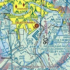
| Sectional chart |
|---|
|
 Download PDF
of official airport diagram from the FAA
| Airport distance calculator |
|---|
|
|
| Sunrise and sunset |
|---|
|
Times for 23-May-2026
| | Local
(UTC-5) | | Zulu
(UTC) |
|---|
| Morning civil twilight | | 05:37 | | 10:37 |
| Sunrise | | 06:04 | | 11:04 |
| Sunset | | 19:50 | | 00:50 |
| Evening civil twilight | | 20:16 | | 01:16 |
|
| Current date and time |
|---|
| Zulu (UTC) | 23-May-2026 14:19:35 |
|---|
| Local (UTC-5) | 23-May-2026 09:19:35 |
|---|
|
| METAR |
|---|
| KNBG | 231355Z AUTO 30005KT 4SM -TSRA BR SCT018 OVC100 24/24 A3003 RMK AO2 TSB42 SLP166 P0004 T02440239
|
KNEW
13nm N | 231353Z 19006KT 5SM BR BKN090 BKN110 25/24 A3002 RMK AO1 LTG DSNT S AND SW SLP160 P0002 T02500239
|
KMSY
16nm NW | 231353Z 20004KT 6SM -TSRA BR FEW045CB BKN095 OVC200 24/23 A3001 RMK AO2 TSE19B24 SLP166 OCNL LTGICCG N TS N MOV N P0009 T02390228
|
|
| TAF |
|---|
| KNBG | 230000Z 2223/2323 21010G20KT 9999 SCT020CB BKN050 BKN120 OVC250 QNH2984INS TEMPO 2223/2303 VRB25G35KT 1600 TSRA BR BKN013CB OVC030 BECMG 2303/2305 19005KT 9999 NSW SCT020 BKN150 BKN250 QNH2993INS BECMG 2315/2317 16007KT 9999 BKN020CB BKN130 OVC250 QNH2988INS TEMPO 2317/2323 VRB25G35KT 1200 +TSRA BR OVC010CB AUTOMATED SENSOR METWATCH 2300 TIL 2610 TX30/2320Z TN23/2311Z AMD 0021 FN00327
|
KNEW
13nm N | 231120Z 2312/2412 12006KT P6SM SCT045 BKN230 PROB30 2314/2318 4SM -TSRA BKN025CB FM231800 13006KT P6SM SCT025 OVC070 PROB30 2318/2324 4SM -TSRA BKN023CB BKN040 FM240500 10007KT P6SM SCT030 OVC110
|
KMSY
16nm NW | 231120Z 2312/2418 17006KT P6SM SCT030 BKN035 PROB30 2315/2318 4SM -TSRA BKN025CB FM231800 16007KT P6SM SCT024 BKN045 PROB30 2318/2324 4SM -TSRA BKN025CB FM241000 11003KT P6SM OVC025
|
|
| NOTAMs |
|---|
NOTAMs are issued by the DoD/FAA and will open in a separate window not controlled by AirNav.
|
|


