FAA INFORMATION EFFECTIVE 11 JUNE 2026
Location
| FAA Identifier: | ASD |
| Lat/Long: | 30-20-46.8000N 089-49-14.9000W
30-20.780000N 089-49.248333W
30.3463333,-89.8208056
(estimated) |
| Elevation: | 28.3 ft. / 9 m (estimated) |
| Variation: | 02E (1995) |
| From city: | 4 miles NW of SLIDELL, LA |
| Time zone: | UTC -5 (UTC -6 during Standard Time) |
| Zip code: | 70460 |
Airport Operations
| Airport use: | Open to the public |
| Control tower: | no |
| ARTCC: | HOUSTON CENTER |
| FSS: | DE RIDDER FLIGHT SERVICE STATION |
| NOTAMs facility: | ASD (NOTAM-D service available) |
| Attendance: | 0700-1600
ARPT UNATNDD THANKSGIVING, CHRISTMAS, NEW YEARS DAY |
| Wind indicator: | lighted |
| Segmented circle: | no |
| Lights: | MIRL RY 18/36, REIL RYS 18 & 36 PRESET LOW INTST DUSK-DAWN; TO INCR INTST ACTVT - CTAF. |
| Beacon: | white-green (lighted land airport)
Operates sunset to sunrise. |
Airport Communications
| CTAF/UNICOM: | 122.8 |
| WX ASOS: | 132.475 (985-259-6242) |
| NEW ORLEANS APPROACH: | 133.15 |
| NEW ORLEANS DEPARTURE: | 133.15 |
| WX AWOS-3PT at MJD (12 nm NE): | 119.075 (601-798-4136) |
| WX AWOS-3PT at HSA (19 nm E): | 118.375 (228-466-9320) |
Nearby radio navigation aids
| VOR radial/distance | | VOR name | | Freq | | Var |
|---|
| PCUr195/13.7 | | PICAYUNE VOR/DME | | 113.95 | | 05E |
| HRVr016/31.2 | | HARVEY VORTAC | | 114.10 | | 02E |
| GPTr263/38.7 | | GULFPORT VORTAC | | 109.00 | | 02E |
| NDB name | | Hdg/Dist | | Freq | | Var | | ID |
|---|
| BOGALUSA | | 176/32.2 | | 353 | | 00W | | GVB | --. ...- -... |
Airport Services
| Fuel available: | 100LL JET-A+
100LL:100LL AVBL 24 HRS WITH CREDIT CARD.
A+:FOR JET FUEL AFTER HOURS CALL 985 259-2460. |
| Parking: | tiedowns |
| Airframe service: | MAJOR |
| Powerplant service: | MAJOR |
| Bottled oxygen: | HIGH |
| Bulk oxygen: | NONE |
Runway Information
Runway 18/36
| Dimensions: | 5002 x 100 ft. / 1525 x 30 m |
| Surface: | asphalt, in good condition |
| Weight bearing capacity: | |
| Runway edge lights: | medium intensity |
| RUNWAY 18 | | RUNWAY 36 |
| Latitude: | 30-21.193185N | | 30-20.368103N |
| Longitude: | 089-49.251922W | | 089-49.243973W |
| Elevation: | 28.2 ft. | | 26.3 ft. |
| Traffic pattern: | left | | left |
| Runway heading: | 178 magnetic, 180 true | | 358 magnetic, 360 true |
| Displaced threshold: | 944 ft. | | no |
| Declared distances: | TORA:5001 TODA:5001 ASDA:5001 LDA:4057 | | TORA:5001 TODA:5001 ASDA:5001 LDA:5001 |
| Markings: | nonprecision, in fair condition | | nonprecision, in fair condition |
| Visual slope indicator: | 2-light PAPI on left (3.00 degrees glide path) | | 2-light PAPI on left (3.00 degrees glide path) |
| Runway end identifier lights: | yes | | yes |
| Touchdown point: | yes, no lights | | yes, no lights |
| Obstructions: | 61 ft. trees, 1766 ft. from runway, 184 ft. right of centerline, 25:1 slope to clear
APCH SLOPE 41:1 TO DSPLCD THLD. | | 85 ft. trees, 3036 ft. from runway, 105 ft. right of centerline, 33:1 slope to clear |
Airport Ownership and Management from official FAA records
| Ownership: | Publicly-owned |
| Owner: | CITY OF SLIDELL
PO BOX 828
SLIDELL, LA 70459
Phone 985-641-7590
MAYOR'S PHONE. |
| Manager: | JAMES FEULNER
62512 AIRPORT RD BLDG 12
SLIDELL, LA 70460
Phone 985-641-7590 |
Additional Remarks
| - | WILDLIFE ON & INVOF RY. |
| - | GCO AVBL ON FREQ 135.075 NEW ORLEANS APCH & DE RIDDER FSS. |
| - | PAJA ON WKENDS. |
| - | FOR CD CTC NEW ORLEANS APCH AT 504-471-4350. |
| - | CTC APRT MGR FOR DSGND RAMP SPACE FOR PUB USE. |
Instrument Procedures
NOTE: All procedures below are presented as PDF files. If you need a reader for these files, you should download the free Adobe Reader.NOT FOR NAVIGATION. Please procure official charts for flight.
FAA instrument procedures published for use from 11 June 2026 at 0901Z to 09 July 2026 at 0900z.
IAPs - Instrument Approach Procedures |
|---|
| RNAV (GPS) RWY 18 | |
download (176KB) |
| RNAV (GPS) RWY 36 | |
download (293KB) |
| NOTE: Special Alternate Minimums apply | |
download (141KB) |
| NOTE: Special Take-Off Minimums/Departure Procedures apply | |
download (116KB) |
Other nearby airports with instrument procedures:
KMJD - Picayune Municipal Airport (12 nm NE)
KHSA - Stennis International Airport (19 nm E)
KNEW - Lakefront Airport (21 nm SW)
KBXA - George R Carr Memorial Air Field (28 nm N)
M13 - Poplarville/Pearl River County Airport (31 nm NE)
|
|

Road maps at:
MapQuest
Bing
Google
| Aerial photo |
|---|
WARNING: Photo may not be current or correct
 Taken in December 2016
looking north.
Taken in December 2016
looking north.
Do you have a better or more recent aerial photo of Slidell Airport that you would like to share? If so, please send us your photo.
|
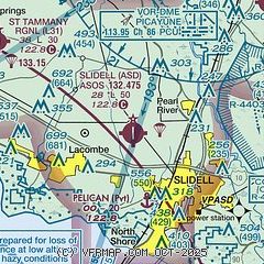
| Sectional chart |
|---|
|
CAUTION: Diagram may not be current

| Airport distance calculator |
|---|
|
|
| Sunrise and sunset |
|---|
|
Times for 13-Jun-2026
| | Local
(UTC-5) | | Zulu
(UTC) |
|---|
| Morning civil twilight | | 05:30 | | 10:30 |
| Sunrise | | 05:58 | | 10:58 |
| Sunset | | 20:01 | | 01:01 |
| Evening civil twilight | | 20:28 | | 01:28 |
|
| Current date and time |
|---|
| Zulu (UTC) | 13-Jun-2026 20:23:14 |
|---|
| Local (UTC-5) | 13-Jun-2026 15:23:14 |
|---|
|
| METAR |
|---|
KASD
6nm SE | 131953Z AUTO 21006KT 10SM CLR 33/20 A3000 RMK AO2 SLP159 T03280200 $
|
KHSA
19nm E | 131847Z 20008KT 10SM BKN040 32/24 A3002
|
|
| TAF |
|---|
KASD
6nm SE | 131727Z 1318/1418 VRB04KT P6SM FEW040 SCT250
|
|
| NOTAMs |
|---|
NOTAMs are issued by the DoD/FAA and will open in a separate window not controlled by AirNav.
|
|


