FAA INFORMATION EFFECTIVE 16 APRIL 2026
Location
| FAA Identifier: | NMM |
| Lat/Long: | 32-33-12.5300N 088-33-18.9500W
32-33.208833N 088-33.315833W
32.5534806,-88.5552639
(estimated) |
| Elevation: | 315.7 ft. / 96.2 m (surveyed) |
| Variation: | 02W (2015) |
| From city: | 11 miles NE of MERIDIAN, MS |
| Time zone: | UTC -5 (UTC -6 during Standard Time) |
| Zip code: | 39335 |
Airport Operations
| Airport use: | Private use. Permission required prior to landing |
| Control tower: | yes |
| ARTCC: | MEMPHIS CENTER |
| FSS: | GREENWOOD FLIGHT SERVICE STATION |
| NOTAMs facility: | NMM (NOTAM-D service available) |
| Attendance: | FRI 1200-2200Z++, ALL MON-THUR 1300-0400++
CLSD SAT, SUN AND HOL EXC BY NOTAM. |
| Pattern altitude: | 1215.7 ft. MSL |
| Segmented circle: | no |
| Lights: | AVBL ONLY DURING HRS OF OPERATION. |
| Beacon: | white-white-green (lighted military airport)
Operates sunset to sunrise. |
Airport Communications
| ATIS: | 290.525 |
| MC CAIN GROUND: | 336.4 [OPR 1300-0500Z++ MON-THUR; 1300-2300Z++ FRI, CLSD SAT, SUN & HOLS EXC BY NOTAM. .] |
| MC CAIN TOWER: | 126.2 340.2 ;RWY 01L, 19L, 28 360.2 ;RWY 01R, 19R, 10 [OPR 1300-0500Z++ MON-THUR; 1300-2300Z++ FRI, CLSD SAT, SUN & HOLS EXC BY NOTAM. .] |
| MERIDIAN APPROACH: | 120.5 ;SOUTH 120.95 ;WEST 121.275 ;EAST 269.325 ;SOUTH 276.4 ;WEST 276.4 348.7 ;EAST 379.275 ;NORTH [OPR 1300-0500Z MON-THUR; 1300-2300Z FRI, CLSD SAT, SUN & HOLS EXC BY NOTAM.] |
| MERIDIAN DEPARTURE: | 124.8 ;SOUTH 276.4 343.7 ;EAST [OPR 1300-0500Z MON-THUR; 1300-2300Z FRI, CLSD SAT, SUN & HOLS EXC BY NOTAM.] |
| CLEARANCE DELIVERY: | 301.0 |
| BASE OPS: | 352.2 |
| EMERG: | 121.5 243.0 |
| IC: | 121.275 ;EAST |
| PMSV METRO: | 282.525 |
| WX ASOS at MEI (17 nm SW): | PHONE 601-207-0082 |
- SFA - 235.625; SFA 236.825; SFA 244.875; SFA 256.875; SFA 323.225 - RADMIN ENTRY CHANGE.
- SFA - 124.8 235.625 236.825 244.875 256.875 266.8 310.8 323.225 328.4.
- APCH/DEP SVC PRVDD BY MEMPHIS ARTCC (ZME) ON FREQS 125.975/351.7 (MERIDIAN RCAG) WHEN MERIDIAN APCH CTL CLSD
- HR SUBJECT TO CHG IN SUPPORT CTW-1 FLT OPR.
Nearby radio navigation aids
| VOR radial/distance | | VOR name | | Freq | | Var |
|---|
| MEIr045/16.4 | | MERIDIAN VORTAC | | 117.00 | | 05E |
Airport Services
| Fuel available: | 100LL JET-A++ J8
100LL:SVC AVBL DURING AIRFIELD HRS OF OPS. EXPECT 1 HR REFUEL DELAYS. |
| Bottled oxygen: | NONE |
| Bulk oxygen: | NONE |
Runway Information
Runway 1L/19R
| Dimensions: | 8003 x 200 ft. / 2439 x 61 m |
| Surface: | concrete |
| Weight bearing capacity: | |
| Runway edge lights: | high intensity |
| RUNWAY 1L | | RUNWAY 19R |
| Latitude: | 32-31.823333N | | 32-33.126833N |
| Longitude: | 088-34.262500W | | 088-34.018500W |
| Elevation: | 253.5 ft. | | 293.8 ft. |
| Traffic pattern: | left | | left |
| Runway heading: | 011 magnetic, 009 true | | 191 magnetic, 189 true |
| Markings: | , in fair condition | | , in fair condition |
| Visual slope indicator: | non-standard VASI system
OPTICAL LANDING SYSTEM & WAVE-OFF. | | 4-light PAPI on right (3.00 degrees glide path) |
| Approach lights: | ALSF1: standard 2,400 foot high intensity approach lighting system with centerline sequenced flashers (category I) | | |
| Centerline lights: | yes | | yes |
| Touchdown point: | yes, no lights | | yes, no lights |
Runway 1R/19L
| Dimensions: | 8000 x 200 ft. / 2438 x 61 m |
| Surface: | concrete |
| Weight bearing capacity: | |
| Runway edge lights: | high intensity |
| RUNWAY 1R | | RUNWAY 19L |
| Latitude: | 32-33.581000N | | 32-34.884000N |
| Longitude: | 088-33.144667W | | 088-32.900167W |
| Elevation: | 269.7 ft. | | 315.7 ft. |
| Traffic pattern: | left | | left |
| Runway heading: | 011 magnetic, 009 true | | 191 magnetic, 189 true |
| Markings: | , in fair condition | | , in fair condition |
| Visual slope indicator: | OPTICAL LANDING SYSTEM. | | non-standard VASI system
OPTICAL LANDING SYSTEM & WAVE-OFF. |
| RVR equipment: | rollout | | touchdown |
| Approach lights: | | | MALSR: 1,400 foot medium intensity approach lighting system with runway alignment indicator lights |
| Centerline lights: | yes | | yes |
| Touchdown point: | yes, no lights | | yes, no lights |
| Instrument approach: | | | ILS/DME |
Runway 10/28
| Dimensions: | 6402 x 200 ft. / 1951 x 61 m |
| Surface: | concrete |
| Weight bearing capacity: | |
| Runway edge lights: | high intensity |
| RUNWAY 10 | | RUNWAY 28 |
| Latitude: | 32-32.929500N | | 32-32.764167N |
| Longitude: | 088-33.267000W | | 088-32.035833W |
| Elevation: | 299.2 ft. | | 303.6 ft. |
| Traffic pattern: | left | | left |
| Runway heading: | 101 magnetic, 099 true | | 281 magnetic, 279 true |
| Touchdown point: | yes, no lights | | yes, no lights |
Airport Ownership and Management from official FAA records
| Ownership: | U.S. Navy |
| Owner: | US NAVY
OCEANOGRAPHIC OFC-CODE 3142
WASHINGTON, DC 20373 |
| Manager: | COMMANDING OFFICER
NAVAL AIR STATION
MERIDIAN, MS 39301
Phone 601 6792470/2505
OPNS DUTY OFF (ODO) ON AUTOVON 446-2470. |
Additional Remarks
| E60-28 | HOOK E28(B) (1250') |
| E60-10 | HOOK E28(B) (1250') |
| E60-01R | HOOK E28(B) (1250') |
| E60-19L | HOOK E28(B) (1748') |
| E60-01L | HOOK E28(B) (1750') |
| E60-19R | HOOK E28(B) (1251') |
| - | LGT: PORTABLE OLS AVBL RWY 01L, 01R, 19L, 19R AND 28. |
| - | JASU: 2(NC-8A) (GTC-85) 1(NCPP-105) |
| - | TRAN ALERT: SVC AVBL 1300-0500Z++ MON-THU, 1300-2300Z++ FRI. DRAG CHUTE REPACK UNAVBL. |
| - | RSTD: ALL ACFT RQR PPR, CTC BASE OPS DSN 637-2470/2505, C601-679-2470/2505. PPR GOOD FOR +/- 1 HR PPR TIME. FOR CALP PROCESSING CTC AFM VIA BASE OPS. |
| - | CAUTION: RWY 19L & 19R HAVE 1 PERCENT DOWN GRAD FIRST 6000 FT.WILDLIFE IN VCNTY ALL RWY. MAT AND TWY S OF HGR NOT VIS FR TWR. INTS STU JET TRNG DUR FLD OPR HR. |
| - | TFC PAT: BRK ALT 1400 FT MSL. TRAN ACFT EXPC VISUAL APCH. VFR ACFT CTC MERIDIAN APP WITHIN 25 NM. |
| - | MISC: RAMP ELEV 283 FT. EXP ARR/DEP DLY EXTSV STU TRNG. NO CLASSIFIED MATERIALS AVBL. |
| - | BASE OPS 1300-0500Z MON-THUR; 1300-2300Z FRI, CLSD SAT, SUN & HOLS EXCP BY NOTAM. . |
| - | SCHEDULING POINT: 187 FW, AL ANG. LOCATION: MONTGOMERY, AL. DSN: 358-9255 C334-394-7255. |
| - | TRANS ALERT: LTD AIRSTART CAPABILITIES FOR TRAN ACFT. CTC 601-679-2342 TO VERIFY STATUS PRIOR TO REQ PPR. |
| - | SERVICE: A-GEAR NORMALLY RIGGED ON ALL RWYS. |
| - | FOR CD WHEN UNA VIA FREQ CTC MERIDIAN APCH 601-679-3691, WHEN MERIDIAN APCH CLSD CTC MEMPHIS ARTCC AT 901-368-8453/8449. |
Instrument Procedures
NOTE: All procedures below are presented as PDF files. If you need a reader for these files, you should download the free Adobe Reader.NOT FOR NAVIGATION. Please procure official charts for flight.
FAA instrument procedures published for use from 16 April 2026 at 0901Z to 14 May 2026 at 0900Z.
IAPs - Instrument Approach Procedures |
|---|
| HI-ILS X OR LOC/DME X RWY 19L | |
download (154KB) |
| HI-ILS Z OR LOC/DME Z RWY 19L | |
download (153KB) |
| ILS W OR LOC/DME W RWY 19L | |
download (134KB) |
| ILS Y OR LOC/DME Y RWY 19L | |
download (132KB) |
| RNAV (GPS) RWY 01L | |
download (88KB) |
| RNAV (GPS) RWY 19L | |
download (90KB) |
| HI-TACAN Z RWY 01L | |
download (155KB) |
| HI-TACAN Z RWY 19L | |
download (151KB) |
| TACAN X RWY 19L | |
download (138KB) |
| TACAN Y RWY 01L | |
download (135KB) |
| TACAN Y RWY 19L | |
download (122KB) |
| Radar Approach Procedures available | |
download (173KB) |
| NOTE: Special Take-Off Minimums/Departure Procedures apply | |
download (293KB) |
Other nearby airports with instrument procedures:
KMEI - Key Field Airport (17 nm SW)
KNJW - Joe Williams Naval Outlying Field (20 nm NW)
KDYA - Demopolis Regional Airport (31 nm E)
KMPE - Philadelphia Municipal Airport (32 nm NW)
09A - Butler/Choctaw County Airport (34 nm SE)
|
|

Road maps at:
MapQuest
Bing
Google
| Aerial photo |
|---|

|
| Sectional chart |
|---|
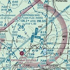
|
 Download PDF
of official airport diagram from the FAA
| Airport distance calculator |
|---|
|
|
| Sunrise and sunset |
|---|
|
Times for 21-Apr-2026
| | Local
(UTC-5) | | Zulu
(UTC) |
|---|
| Morning civil twilight | | 05:53 | | 10:53 |
| Sunrise | | 06:19 | | 11:19 |
| Sunset | | 19:27 | | 00:27 |
| Evening civil twilight | | 19:53 | | 00:53 |
|
| Current date and time |
|---|
| Zulu (UTC) | 21-Apr-2026 17:42:08 |
|---|
| Local (UTC-5) | 21-Apr-2026 12:42:08 |
|---|
|
| METAR |
|---|
| KNMM | 211656Z 18006KT 10SM BKN250 24/07 A3030 RMK AO2 SLP268 T02440072
|
KMEI
16nm SW | 211658Z 14008G16KT 10SM CLR 26/06 A3029 RMK AO2 SLP257 T02560056
|
|
| TAF |
|---|
| KNMM | 211400Z 2115/2215 VRB04KT 9999 SCT250 QNH3027INS FM211700 15007KT 9999 FEW050 SCT120 BKN250 QNH3014INS FM220100 VRB05KT 9999 FEW040 SCT100 BKN200 QNH3015INS TX28/2121Z TN14/2210Z FN20088
|
KMEI
16nm SW | 211158Z 2112/2212 07008KT P6SM SCT250
|
|
| NOTAMs |
|---|
NOTAMs are issued by the DoD/FAA and will open in a separate window not controlled by AirNav.
|
|


