FAA INFORMATION EFFECTIVE 22 JANUARY 2026
Location
| FAA Identifier: | NQX |
| Lat/Long: | 24-34-28.6935N 081-41-11.9236W
24-34.478225N 081-41.198727W
24.5746371,-81.6866454
(estimated) |
| Elevation: | 5.7 ft. / 2 m (estimated) |
| Variation: | 06W (2020) |
| From city: | 4 miles E of KEY WEST, FL |
| Time zone: | UTC -5 (UTC -4 during Daylight Saving Time) |
| Zip code: | 33040 |
Airport Operations
| Airport use: | Private use. Permission required prior to landing |
| Activation date: | 02/1944 |
| Control tower: | yes |
| ARTCC: | MIAMI CENTER |
| FSS: | MIAMI FLIGHT SERVICE STATION |
| NOTAMs facility: | MIA (NOTAM-D service available) |
| Attendance: | 1200-0300Z
OT BY NOTAM; CTC ATC, C305-293-2770. FOR AIR SERVICES OR PPRS CONTACT C305-293-2779. |
| Segmented circle: | no |
| Lights: | AVBL DURG OPS HRS. |
| Beacon: | white-white-green (lighted military airport)
Operates sunset to sunrise. |
Airport Communications
| ATIS: | 307.025 |
| NAVY KEY WEST GROUND: | 121.7 336.45 [1200-0300Z++, OTHER TIMES BY NOTAM.] |
| NAVY KEY WEST TOWER: | 118.575 305.95 340.25 361.25 [1200-0300Z++, OTHER TIMES BY NOTAM.] |
| NAVY KEY WEST APPROACH: | 124.025 313.7 [1200-0300Z++] |
| MIAMI ARTCC APPROACH: | 126.575 289.85 |
| NAVY KEY WEST DEPARTURE: | 124.025 313.7 [1200-0300Z++] |
| MIAMI ARTCC DEPARTURE: | 126.575 289.85 |
| CLEARANCE DELIVERY: | 121.2 357.4 |
| BASE OPS: | 338.15 |
| EMERG: | 121.5 243.0 |
| PMSV METRO: | 343.5 |
| WX ASOS at EYW (4 nm W): | PHONE 863-244-0212 |
- APCH/DEP SVC PRVDD BY KEY WEST NAS OT MIAMI ARTCC ON FREQS 133.5/306.9 (KEY WEST RCAG) WHEN NAVY KEY WEST APCH CTL CLSD.
- SFA.
- AIRCRAFT OVERFLYING SIMPL, ACRUZ, CANOA AND MAXIM SHALL CONTACT MIAMI ARTCC 10 MINUTES PRIOR TO CROSSING THE MIAMI FIR ON 132.2 / 323.1.
- FIELD CARRIER LANDING PACTICE.
Nearby radio navigation aids
| VOR radial/distance | | VOR name | | Freq | | Var |
|---|
| EYWr095/6.2 | | KEY WEST VORTAC | | 113.50 | | 01E |
Airport Services
| Fuel available: | J5
J5:AVBL 1100-0400Z++MON-SAT, SUN 1400-0000Z++. |
| Airframe service: | NONE |
| Powerplant service: | NONE |
| Bottled oxygen: | NONE |
| Bulk oxygen: | NONE |
Runway Information
Runway 8/26
| Dimensions: | 10001 x 200 ft. / 3048 x 61 m |
| Surface: | PEM, in fair condition |
| Weight bearing capacity: | |
| Runway edge lights: | high intensity |
| RUNWAY 8 | | RUNWAY 26 |
| Latitude: | 24-34.349500N | | 24-34.831333N |
| Longitude: | 081-42.004667W | | 081-40.277667W |
| Elevation: | 3.7 ft. | | 3.9 ft. |
| Traffic pattern: | left | | left |
| Runway heading: | 079 magnetic, 073 true | | 259 magnetic, 253 true |
| Markings: | precision, in good condition | | precision, in good condition |
| Visual slope indicator: | 4-light PAPI on left (3.00 degrees glide path) | | 4-light PAPI on left (3.00 degrees glide path) |
| Approach lights: | ALSF1: standard 2,400 foot high intensity approach lighting system with centerline sequenced flashers (category I) | | |
| Touchdown point: | yes, no lights | | yes, no lights |
Runway 4/22
| Dimensions: | 7001 x 150 ft. / 2134 x 46 m |
| Surface: | PEM, in fair condition |
| Weight bearing capacity: | |
| Runway edge lights: | high intensity |
| RUNWAY 4 | | RUNWAY 22 |
| Latitude: | 24-33.943000N | | 24-34.928500N |
| Longitude: | 081-41.754000W | | 081-41.093333W |
| Elevation: | 3.3 ft. | | 5.5 ft. |
| Traffic pattern: | left | | left |
| Runway heading: | 038 magnetic, 032 true | | 218 magnetic, 212 true |
| Markings: | precision, in good condition | | nonprecision, in good condition |
| Visual slope indicator: | 4-light PAPI on left (3.00 degrees glide path) | | 4-light PAPI on left (3.00 degrees glide path) |
| Touchdown point: | yes, no lights | | yes, no lights |
Runway 14/32
| Dimensions: | 7000 x 150 ft. / 2134 x 46 m |
| Surface: | PEM, in fair condition |
| Weight bearing capacity: | |
| Runway edge lights: | high intensity |
| RUNWAY 14 | | RUNWAY 32 |
| Latitude: | 24-34.738667N | | 24-33.982000N |
| Longitude: | 081-41.533333W | | 081-40.578667W |
| Elevation: | 3.3 ft. | | 3.2 ft. |
| Traffic pattern: | left | | left |
| Runway heading: | 137 magnetic, 131 true | | 317 magnetic, 311 true |
| Markings: | nonprecision, in good condition | | nonprecision, in good condition |
| Visual slope indicator: | 4-light PAPI on right (3.00 degrees glide path) | | 4-light PAPI on left (3.00 degrees glide path) |
| Touchdown point: | yes, no lights | | yes, no lights |
Airport Ownership and Management from official FAA records
| Ownership: | U.S. Navy |
| Owner: | US NAVY
OCEANOGRAPHIC OFC-CODE 3142
WASHINGTON, DC 20373 |
| Manager: | COMMANDING OFFICER
NAVAL AIR STATION
KEY WEST, FL 33040
Phone 305-293-2770 |
Additional Remarks
| E60-22 | HOOK E28(B) (1202 FT) |
| E60-32 | HOOK E28(B) (1501 FT) |
| E60-08 | HOOK E28(B) (1500 FT) |
| E60-26 | HOOK E28(B) (1501 FT) |
| E60-04 | HOOK E28(B) (1500 FT) |
| E60-14 | HOOK E28(B) (1135 FT) |
| - | A-GEAR: ALL E-28(B) SHORT FLD A-G IN RAISED POSN. EXC SHORT FLD A-G DUTY RWY DERIGGED. |
| - | JASU: (NC-10) (MSU-200) |
| - | FLUID: SP |
| - | OIL: -O-128-156 |
| - | RSTD: UNLGTD RAMP PARL TO TWY L. |
| - | TFC PAT: REDUCED RWY SEPARATION STD IN EFF USN/USMC ACFT. |
| - | CSTMS/AG/IMG: AVLB 1200-2000Z++ MON - SAT, WITH PRIOR COORDINATION. ACFT REQ INSPECTIONS MUST ANNOTATE ON PPR AND NOTIFY NAVY APP WHEN IN RDO CTC WITH UPDATED ETA AND REQUEST CSTMS COORDINATION, FAILURE MAY CAUSE UNDUE DELAYS WITH CSTMS LIMITED RESOURCES. |
| - | RSTD: PPR CTC AIR TERMINAL DSN 483-2769/2779, 305-293-2769/2779, FAX DSN 483-2355, C305-293-2355. |
| - | CAUTION: UNLGT RAMP PARL TO TWY I; R2916 TETHERED AEROSTAT RADAR SYSTEM OPS CONT TO 14000; KEY WEST NAS & KEY WEST INTL HAVE ADJ CLASS D; CIVIL TFC SW & NW SECTS KEY WEST NAS CLASS D; BIRD HAZ; UNMRK/UNLGT TWY OBSTN. |
| - | HAZARDOUS CARGO, TRANSIENT RAMP, AND FIGHTER RAMP LABELS. |
| - | HOT CARGO PAD UNLIT; DAY USE ONLY. |
| - | RSTD: PPR IS VALID FOR +/- 1 HR OF PROPOSED ETA. IF OUTSIDE OF ETA SLOT, CTC AIR TRML TO UPDATE PPR. |
| - | MISC: FIGHTER ACFT OPS DLY M-SA 0800-1700. TRAN ACFT PRAC APCH NOT TO INTERFERE BASIS; PPR FOR COPTER LDG TRUMBO PT - CTC BASE OPS 15 MIN PRIOR TO ETA. |
| - | SAR ONLY AVBL ON SAT-SUN WITH PRIOR CDN AND SKED ASP BY FRI PRIOR TO 1300Z++. |
| - | TRAN ALERT: EXP SVC DELAYS; NO PRIORITY BASIS; LTD MAINT 1200-2100Z++ MON-FRI; TRANS ACFT RQRG FUEL PRVD QLFYD PSNL; FLEET SVC, POTABLE WATER & BASE TRNSPN NA; CLSD FED HOL. |
| - | RSTD: CIV ACFT LDG PMT INFO - AMGR 305-293-2250; 305-293-2779. |
| - | CAUTION: RWY 04/22, 7 FT OBST 87 FT WEST OF CNTRLN. FLOLS. 758 FT FM APCH END RWY 04, DER RWY 22. ONLY C-130 (WINGSPAN 32 FT) TYPE ACFT OR SMLR MAY OPR FOR LDG AND TKOF. ALL ACFT MAY TAXI DOWN RWY 22 TIL THE DER A-G. |
| - | MISC: EV THU ALL APCHS PRIOR TO 1030L WILL BE IAW IFR PROCS. |
Instrument Procedures
NOTE: All procedures below are presented as PDF files. If you need a reader for these files, you should download the free Adobe Reader.NOT FOR NAVIGATION. Please procure official charts for flight.
FAA instrument procedures published for use from 22 January 2026 at 0901Z to 19 February 2026 at 0900z.
STARs - Standard Terminal Arrivals |
|---|
| FNTSY ONE (RNAV) | |
2 pages:
[1] [2] (378KB) |
| KRAKN ONE (RNAV) | |
2 pages:
[1] [2] (407KB) |
IAPs - Instrument Approach Procedures |
|---|
| RNAV (GPS) RWY 04 | |
download (120KB) |
| RNAV (GPS) RWY 08 | |
download (128KB) |
| RNAV (GPS) RWY 14 | |
download (100KB) |
| RNAV (GPS) RWY 26 | |
download (90KB) |
| RNAV (GPS) RWY 32 | |
download (99KB) |
| VOR/DME RWY 26 | |
download (152KB) |
| VOR/DME OR TACAN Z RWY 08 | |
download (138KB) |
| HI-TACAN W RWY 08 | |
download (167KB) |
| HI-TACAN X RWY 08 | |
download (160KB) |
| HI-TACAN Z RWY 04 | |
download (171KB) |
| HI-TACAN Z RWY 32 | |
download (164KB) |
| TACAN RWY 26 | |
download (144KB) |
| TACAN Y RWY 04 | |
download (153KB) |
| TACAN Y RWY 08 | |
download (154KB) |
| TACAN Y RWY 32 | |
download (155KB) |
| COPTER TACAN W RWY 04 | |
download (119KB) |
| Radar Approach Procedures available | |
download (176KB) |
|
|---|
| BOCA SIX (OBSTACLE) | |
download (112KB) |
| TIGAR FOUR (OBSTACLE) | |
download (113KB) |
| NOTE: Special Take-Off Minimums/Departure Procedures apply | |
download (406KB) |
Other nearby airports with instrument procedures:
KEYW - Key West International Airport (4 nm W)
KMTH - The Florida Keys Marathon International Airport (36 nm E)
X51 - Miami Homestead General Aviation Airport (83 nm NE)
KMKY - Marco Island Executive Airport (85 nm N)
KTNT - Dade-Collier Training and Transition Airport (88 nm NE)
|
|

Road maps at:
MapQuest
Bing
Google
| Aerial photo |
|---|
WARNING: Photo may not be current or correct
 Photo by David Newcomer
Photo taken 25-May-2013
from 3,000' looking south.
Photo by David Newcomer
Photo taken 25-May-2013
from 3,000' looking south.
Do you have a better or more recent aerial photo of Key West Naval Air Station (Boca Chica Field) Airport that you would like to share? If so, please send us your photo.
|
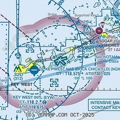
| Sectional chart |
|---|
|
 Download PDF
of official airport diagram from the FAA
| Airport distance calculator |
|---|
|
|
| Sunrise and sunset |
|---|
|
Times for 18-Feb-2026
| | Local
(UTC-5) | | Zulu
(UTC) |
|---|
| Morning civil twilight | | 06:36 | | 11:36 |
| Sunrise | | 06:59 | | 11:59 |
| Sunset | | 18:22 | | 23:22 |
| Evening civil twilight | | 18:45 | | 23:45 |
|
| Current date and time |
|---|
| Zulu (UTC) | 19-Feb-2026 04:43:47 |
|---|
| Local (UTC-5) | 18-Feb-2026 23:43:47 |
|---|
|
| METAR |
|---|
| KNQX | 190353Z AUTO 13008KT 10SM CLR 23/20 A3003 RMK AO2 SLP169 T02280200 $
|
KEYW
4nm SW | 190353Z AUTO 12008KT 10SM CLR 24/21 A3003 RMK AO2 SLP176 T02390206 $
|
|
| TAF |
|---|
| KNQX | 1823/1923 12009KT 9999 FEW025 QNH3000INS FM191400 13011KT 9999 FEW025 QNH2993INS AUTOMATED SENSOR METWATCH 1903 TIL 1911 TX27/1919Z TN21/1912Z FN20056
|
KEYW
4nm SW | 181720Z 1818/1918 13010KT P6SM FEW025
|
|
| NOTAMs |
|---|
NOTAMs are issued by the DoD/FAA and will open in a separate window not controlled by AirNav.
|
|


