FAA INFORMATION EFFECTIVE 09 JULY 2026
Location
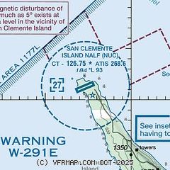
| FAA Identifier: | NUC |
| Lat/Long: | 33-01-21.8964N 118-35-18.5906W
33-01.364940N 118-35.309843W
33.0227490,-118.5884974
(estimated) |
| Elevation: | 183.7 ft. / 56.0 m (surveyed) |
| Variation: | 12E (2020) |
| Time zone: | UTC -7 (UTC -8 during Standard Time) |
| Zip code: | 90731 |
Airport Operations
| Airport use: | Private use. Permission required prior to landing |
| Control tower: | yes |
| ARTCC: | LOS ANGELES CENTER |
| FSS: | SAN DIEGO FLIGHT SERVICE STATION |
| NOTAMs facility: | NUC (NOTAM-D service available) |
| Attendance: | MON 1500-0200Z+, ALL TUE-THU 1600-0200Z+, ALL FRI 1600-0000Z+, CLSD SAT, SUN AND HOL.
OTHER TIMES BY NOTAM. |
| Segmented circle: | no |
| Lights: | AVBL ONLY DRG HRS OF OPN. AFTER HRS FOR EMERG ACTVT HIRL RWY 06/24 5 STEP AND REIL RWY 24 1 STEP - 119.55. |
| Beacon: | white-white-green (lighted military airport)
Operates sunset to sunrise. |
Airport Communications
| ATIS: | 268.6 |
| SAN CLEMENTE ISLAND GROUND: | 119.55 251.05 [0800-1800 MON-THU; 0800-1600 FRI; CLSD WKEND & HOL, OTHER TIMES BY NOTAM.] |
| SAN CLEMENTE ISLAND TOWER: | 126.75 278.8 340.2 [0800-1800 MON-THU; 0800-1600 FRI; CLSD WKEND & HOL, OTHER TIMES BY NOTAM.] |
| SAN CLEMENTE APPROACH: | 127.05 292.15 [0800-1800 MON-THU; 0800-1600 FRI; CLSD WKEND & HOL, OTHER TIMES BY NOTAM.] |
| SAN CLEMENTE DEPARTURE: | 127.05 292.15 [0800-1800 MON-THU; 0800-1600 FRI; CLSD WKEND & HOL, OTHER TIMES BY NOTAM.] |
| EMERG: | 121.5 243.0 |
- RADAR ADVSY SVC - (R) (E) REMARKS: CTC TWR 20 NM OUT. BEAVER CON - 120.85 266.9. REMARKS: ACFT TRNS W291 CTC BEAVER CON 120.85 266.9.
- ASR NO-NOTAM MP 1800-2200Z++ TUE.
Nearby radio navigation aids
| VOR radial/distance | | VOR name | | Freq | | Var |
|---|
| SXCr187/22.8 | | SANTA CATALINA VORTAC | | 114.15 | | 15E |
Airport Services
| Bottled oxygen: | NONE |
| Bulk oxygen: | NONE |
Runway Information
Runway 6/24
| Dimensions: | 9301 x 200 ft. / 2835 x 61 m |
| Surface: | concrete |
| Weight bearing capacity: | |
| Runway edge lights: | high intensity |
| RUNWAY 6 | | RUNWAY 24 |
| Latitude: | 33-01.068967N | | 33-01.660915N |
| Longitude: | 118-36.149572W | | 118-34.470113W |
| Elevation: | 90.9 ft. | | 183.7 ft. |
| Traffic pattern: | left | | left |
| Runway heading: | 055 magnetic, 067 true | | 235 magnetic, 247 true |
| Approach lights: | | | OLS |
| Runway end identifier lights: | no | | yes |
| Touchdown point: | yes, no lights | | yes, no lights |
Helipad H1
| Dimensions: | 70 x 70 ft. / 21 x 21 m |
| Surface: | concrete |
| Latitude: | 33-01.400000N | | |
| Longitude: | 118-34.983333W | | |
| Elevation: | 170.0 ft. | | |
| Traffic pattern: | left | | left |
Helipad H2
| Dimensions: | 70 x 70 ft. / 21 x 21 m |
| Surface: | concrete |
| Latitude: | 33-01.300000N | | |
| Longitude: | 118-35.216667W | | |
| Elevation: | 146.0 ft. | | |
| Traffic pattern: | left | | left |
Airport Ownership and Management from official FAA records
| Ownership: | U.S. Navy |
| Owner: | US NAVY
OCEANOGRAPHIC OFC - CODE 3142
WASHINGTON, DC 20373 |
Additional Remarks
| - | PRKG RAMP DESIGNED FOR FIVE METROLINER SIZED ACFT (ON THE LINE ADJACENT TO THE TRML) AND EIGHT H-60 SIZED ACFT (ON THE NORTHERN TWO LINES - 4 EACH LINE). WHEN CARGO ACFT OCCUPY THE CENTER PRKG LINE (VIC OF SPOT 5) NONSTD TAXILANE CLNC MAY EXIST, USE CTN TAXING AROUND CARGO ACFT. |
| - | WHEN ATCT CLSD, FOR CD CTC LOS ANGELES ARTCC AT 661-575-2079. |
| - | FOR CALP INFO CTC AIRFIELD MGR 619-545-8261. |
| - | SIMULATED ACFT CARRIER DECK LGTS U/S. |
| - | STD PRKG APRON WO A PERIPHERAL TXL. |
| - | AD HAS NSTD AIRFIELD SIGNAGE. |
| - | JASU - 1(GTC-85) 1(A-4). |
| - | FUEL - J5. |
| - | FLUID - SP. |
| - | CAUTION: EXTV MISL AND OFF-SHORE BOMBARDMENT IN VCNTY SAN CLEMENTE ISLAND. PERIMETER RD IN CLOSE PROXIMITY TO AIRFIELD, USE EXTREME CAUTION. HOLD SHORT MARKINGS LESS THAN 175 FT. EXPECT HOLD SHORT INSTRUCTIONS FROM TOWER. |
| - | TFC PAT REDUCED RWY SEPARATION STD IN EFF USN/USMC ACFT (ONLY ALLOWED DURING CCAS). |
| - | RSTD - PPR FOR CIV ACFT AT ALL TIMES AND MIL OT, DSN 524-9240. REQ TO USE NUC AS BINGO FLD FOR CARRIER OPR RQR 7 DAYS PN AND SPECIAL AIR OPR AFTER NML OPR HR RQR 72 HR PN THRU SAN CLEMENTE ISLAND AIR OPS DSN 524-9240. |
Instrument Procedures
NOTE: All procedures below are presented as PDF files. If you need a reader for these files, you should download the free Adobe Reader.NOT FOR NAVIGATION. Please procure official charts for flight.
FAA instrument procedures published for use from 09 July 2026 at 0901Z to 06 August 2026 at 0900Z.
IAPs - Instrument Approach Procedures |
|---|
| RNAV (GPS) RWY 24 | |
download (93KB) |
| TACAN RWY 24 | |
download (106KB) |
| NOTE: Special Take-Off Minimums/Departure Procedures apply | |
download (251KB) |
Other nearby airports with instrument procedures:
KAVX - Catalina Airport (25 nm N)
KNSI - San Nicolas Island Naval Outlying Field (46 nm W)
KTOA - Zamperini Field Airport (48 nm N)
KLGB - Long Beach Airport (Daugherty Field) (52 nm NE)
KSNA - John Wayne/Orange County Airport (53 nm NE)
|
|

Road maps at:
MapQuest
Bing
Google
| Aerial photo |
|---|
WARNING: Photo may not be current or correct

Do you have a better or more recent aerial photo of San Clemente Island NALF that you would like to share? If so, please send us your photo.
|
| Sectional chart |
|---|
|
 Download PDF
of official airport diagram from the FAA
| Airport distance calculator |
|---|
|
|
| Sunrise and sunset |
|---|
|
Times for 03-Aug-2026
| | Local
(UTC-7) | | Zulu
(UTC) |
|---|
| Morning civil twilight | | 05:43 | | 12:43 |
| Sunrise | | 06:10 | | 13:10 |
| Sunset | | 19:51 | | 02:51 |
| Evening civil twilight | | 20:18 | | 03:18 |
|
| Current date and time |
|---|
| Zulu (UTC) | 03-Aug-2026 16:13:28 |
|---|
| Local (UTC-7) | 03-Aug-2026 09:13:28 |
|---|
|
| METAR |
|---|
| KNUC | 031456Z 27006KT 6SM BR BKN008 OVC010 19/18 A2985 RMK SLPNO T01940178 53004
|
|
| NOTAMs |
|---|
NOTAMs are issued by the DoD/FAA and will open in a separate window not controlled by AirNav.
|
|


