FAA INFORMATION EFFECTIVE 17 APRIL 2025
Location
| FAA Identifier: | OKB |
| Lat/Long: | 33-13-04.7150N 117-21-05.4270W
33-13.078583N 117-21.090450W
33.2179764,-117.3515075
(estimated) |
| Elevation: | 28 ft. / 8.5 m (surveyed) |
| Variation: | 13E (1985) |
| From city: | 2 miles NE of OCEANSIDE, CA |
| Time zone: | UTC -7 (UTC -8 during Standard Time) |
| Zip code: | 92054 |
Airport Operations
| Airport use: | Open to the public |
| Activation date: | 06/1963 |
| Control tower: | no |
| ARTCC: | LOS ANGELES CENTER |
| FSS: | SAN DIEGO FLIGHT SERVICE STATION |
| NOTAMs facility: | OKB (NOTAM-D service available) |
| Attendance: | 0900-1700 |
| Wind indicator: | lighted |
| Segmented circle: | yes |
| Lights: | MIRL RWY 07/25 PRESET LOW INTST; TO INCR INTST ACTVT - CTAF. |
| Beacon: | white-green (lighted land airport)
Operates sunset to sunrise. |
Airport Communications
| CTAF/UNICOM: | 122.725 |
| WX ASOS: | 127.8 (760-439-9683) |
| SOCAL APPROACH: | 127.3 |
| SOCAL DEPARTURE: | 127.3 |
| CLASS B: | 127.3 ;294-332 SAN BLW 7,000 FT |
| WX ASOS at CRQ (6 nm SE): | PHONE 760-930-0864 |
| WX AWOS-3P at L18 (10 nm NE): | 118.425 (760-723-6073) |
- COMMUNICATIONS PRVDD BY SAN DIEGO RADIO ON FREQS 122.1R/115.3T (OCEANSIDE RCO).
Nearby radio navigation aids
| VOR radial/distance | | VOR name | | Freq | | Var |
|---|
| OCNr097/3.6 | | OCEANSIDE VORTAC | | 115.30 | | 15E |
| MZBr331/26.9 | | MISSION BAY VORTAC | | 117.80 | | 15E |
| ELBr131/33.4 | | EL TORO VOR/DME | | 117.20 | | 14E |
| HDFr180/(34.5) | | HOMELAND VOR | | 112.05 | | 14E |
| JLIr262/38.7 | | JULIAN VORTAC | | 114.00 | | 15E |
Airport Services
| Fuel available: | 100LL JET-A
100LL:FUEL AVBL 24 HRS 100LL SELF SVC, FULL SVC 0900-1630; JET A 0900-1700. |
| Parking: | tiedowns |
| Airframe service: | MINOR |
| Powerplant service: | MAJOR |
| Bottled oxygen: | NONE |
| Bulk oxygen: | NONE |
Runway Information
Runway 7/25
| Dimensions: | 2712 x 75 ft. / 827 x 23 m |
| Surface: | asphalt, in good condition |
| Weight bearing capacity: | |
| Runway edge lights: | medium intensity |
| RUNWAY 7 | | RUNWAY 25 |
| Latitude: | 33-13.039573N | | 33-13.117583N |
| Longitude: | 117-21.352547W | | 117-20.828467W |
| Elevation: | 24.5 ft. | | 28.0 ft. |
| Traffic pattern: | left | | right |
| Runway heading: | 067 magnetic, 080 true | | 247 magnetic, 260 true |
| Markings: | nonprecision, in good condition | | nonprecision, in good condition |
| Runway end identifier lights: | no | | yes |
| Touchdown point: | yes, no lights | | yes, no lights |
| Obstructions: | 15 ft. road, 420 ft. from runway, 125 ft. both sides of centerline, 15:1 slope to clear
8 FT FENCE, ROAD, AND 8+ FT TFC SIGNAL AT 345 FT. | | 210 ft. hill, 5300 ft. from runway, 24:1 slope to clear |
Airport Ownership and Management from official FAA records
| Ownership: | Publicly-owned |
| Owner: | CITY OF OCEANSIDE
300 NORTH COAST HIGHWAY
OCEANSIDE, CA 92054
Phone (760) 435-5012 |
| Manager: | ANDREW WIGNOT
480 AIRPORT ROAD, SUITE 715
OCEANSIDE, CA 92058
Phone (760) 901-4260 |
Additional Remarks
| - | FENCE & ROAD WITHIN PRIMARY SFC NORTH SIDE. |
| - | FOR CD CTC SOCAL APCH AT 800-448-3724. |
| - | LEFT TFC TO RWY 25 PROHIBITED FOR NOISE ABATEMENT. |
| - | MTS W, NW, SW RWY 07 UP TO 280 FT MSL. |
| - | UNLGTD MT APRX 160 FT MSL IN APCH ZONE AT 3500 FT FROM W END OF PVMT RWY 07. |
| - | NOISE ABATEMENT IN EFCT: FLW RIVERBED ALL THE WAY TO COAST PRIOR TO MAKING ANY TURNS. DO NOT FLY OVER ANY HOUSES ALG RIVER BANKS. NO EARLY TURNOUTS PRIOR TO THE OCEAN. SKYDIVING OPS IN EFCT SR-SS DLY. PRCHT LNDG NORTH SIDE OF RWY BTW DOWNWIND AND RWY; NO EFCT ON ACFT TKOF/LNDG THAT FLW TFC PAT. USE CTN WHILE IN THE PAT. |
| - | DO NOT CONFUSE ROAD SOUTH OF ARPT WITH THE RWY. |
| - | BIRDS ON AND INVOF ARPT. |
Instrument Procedures
NOTE: All procedures below are presented as PDF files. If you need a reader for these files, you should download the free Adobe Reader.NOT FOR NAVIGATION. Please procure official charts for flight.
FAA instrument procedures published for use from 17 April 2025 at 0901Z to 15 May 2025 at 0900z.
IAPs - Instrument Approach Procedures |
|---|
| RNAV (GPS) RWY 07 | |
download (216KB) |
| RNAV (GPS) RWY 25 | |
download (304KB) |
| VOR-A | |
download (290KB) |
| NOTE: Special Alternate Minimums apply | |
download (141KB) |
|
|---|
| OCEANSIDE ONE (OBSTACLE) | |
2 pages:
[1] [2] (752KB) |
| NOTE: Special Take-Off Minimums/Departure Procedures apply | |
download (357KB) |
Other nearby airports with instrument procedures:
KNFG - Camp Pendleton MCAS (Munn Field) Airport (5 nm N)
KCRQ - Mc Clellan-Palomar Airport (6 nm SE)
L18 - Fallbrook Community Airpark (10 nm NE)
KNKX - Miramar MCAS (Joe Foss Field) Airport (23 nm SE)
F70 - French Valley Airport (24 nm NE)
|
|

Road maps at:
MapQuest
Bing
Google
| Aerial photo |
|---|
WARNING: Photo may not be current or correct
 Photo courtesy of focalflight.com
Photo taken 02-Feb-2015
looking north.
Photo courtesy of focalflight.com
Photo taken 02-Feb-2015
looking north.
Do you have a better or more recent aerial photo of Bob Maxwell Memorial Airfield that you would like to share? If so, please send us your photo.
|
| Sectional chart |
|---|
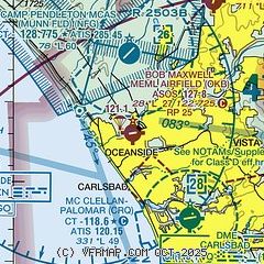
|
| Airport distance calculator |
|---|
|
|
| Sunrise and sunset |
|---|
|
Times for 24-Apr-2025
| | Local
(UTC-7) | | Zulu
(UTC) |
|---|
| Morning civil twilight | | 05:44 | | 12:44 |
| Sunrise | | 06:10 | | 13:10 |
| Sunset | | 19:25 | | 02:25 |
| Evening civil twilight | | 19:51 | | 02:51 |
|
| Current date and time |
|---|
| Zulu (UTC) | 24-Apr-2025 12:36:10 |
|---|
| Local (UTC-7) | 24-Apr-2025 05:36:10 |
|---|
|
| METAR |
|---|
| KOKB | 241152Z AUTO 00000KT 6SM HZ OVC037 14/02 A2997 RMK AO2 SLP147 T01390017 10150 20139 58005 $
|
KNFG
4nm N | 241151Z AUTO 00000KT 10SM OVC034 13/10 A2998 RMK AO2 SLP150 T01330100 10139 20128 58005
|
KCRQ
6nm SE | 241153Z AUTO 17003KT 10SM OVC033 14/08 A2996 RMK AO2 SLP145 T01390078 10144 20139 58005
|
KL18
10nm NE | 241215Z AUTO 00000KT 10SM OVC031 12/09 A2998 RMK AO2
|
|
| TAF |
|---|
KNFG
4nm N | 2409/2509 VRB03KT 9999 OVC030 QNH2998INS FM241330 VRB05KT 9999 BKN020 QNH2997INS BECMG 2417/2419 24008KT 9999 FEW030 QNH2993INS BECMG 2501/2503 SCT030 QNH2993INS TX19/2421Z TN12/2411Z
|
KCRQ
6nm SE | 241126Z 2412/2512 VRB04KT P6SM OVC030 FM241800 24009KT P6SM FEW025 FM250400 VRB04KT P6SM OVC025 FM251000 VRB04KT 6SM -DZ OVC025
|
|
| NOTAMs |
|---|
NOTAMs are issued by the DoD/FAA and will open in a separate window not controlled by AirNav.
|
|


