FAA INFORMATION EFFECTIVE 09 JULY 2026
Location
| FAA Identifier: | CRQ |
| Lat/Long: | 33-07-41.7000N 117-16-48.3000W
33-07.695000N 117-16.805000W
33.1282500,-117.2800833
(estimated) |
| Elevation: | 330.5 ft. / 100.7 m (surveyed) |
| Variation: | 14E (1980) |
| From city: | 3 miles SE of CARLSBAD, CA |
| Time zone: | UTC -7 (UTC -8 during Standard Time) |
| Zip code: | 92011 |
Airport Operations
| Airport use: | Open to the public |
| Activation date: | 05/1959 |
| Control tower: | yes |
| ARTCC: | LOS ANGELES CENTER |
| FSS: | SAN DIEGO FLIGHT SERVICE STATION |
| NOTAMs facility: | CRQ (NOTAM-D service available) |
| Attendance: | 0700-2200 |
| Pattern altitude: | TPA 672 AGL HELICOPTERS; 1172 AGL SMALL ACFT; 1672 AGL LARGE ACFT. |
| Wind indicator: | no |
| Segmented circle: | yes |
| Lights: | WHEN ATCT CLSD ACTVT HIRL RWY 06/24, PAPI RWYS 06 & 24, MALSR RWY 24 - CTAF. |
| Beacon: | white-green (lighted land airport)
Operates sunset to sunrise. |
| Landing fee: | yes |
| Fire and rescue: | ARFF index A |
| Airline operations: | CLOSED TO AIR CARRIER OPNS WITH MORE THAN 9 PASSENGER SEATS FM 2230 TO 0600 EXCEPT BY PPR CALL AMGR 760-431-4646. |
| International operations: | US CUSTOMS USER FEE ARPT, CTC 877-848-7766. |
Airport Communications
| CTAF: | 118.6 |
| ATIS: | 120.15 |
| WX ASOS: | PHONE 760-795-2628 |
| PALOMAR GROUND: | 121.8 [0700-2200] |
| PALOMAR TOWER: | 118.6 276.4 [0700-2200] |
| SOCAL APPROACH: | 127.3 |
| SOCAL DEPARTURE: | 127.3 |
| CLEARANCE DELIVERY: | 134.85 |
| CLASS B: | 127.3 ;294-332 SAN BLW 7,000 FT |
| CWARD DP: | 119.6 |
| LEGOZ STAR: | 127.4 |
| PADRZ DP: | 119.6 |
| PMSV METRO: | 344.6 |
| WX ASOS at OKB (6 nm NW): | 127.8 (760-439-9683) |
| WX AWOS-3P at L18 (14 nm N): | 118.425 (760-723-6073) |
| WX ASOS at RNM (19 nm E): | PHONE 760-239-7043 |
- COMMUNICATIONS PRVDD BY SAN DIEGO RADIO ON FREQS 122.1R/115.3T (OCEANSIDE RCO).
Nearby radio navigation aids
| VOR radial/distance | | VOR name | | Freq | | Var |
|---|
| OCNr119/9.7 | | OCEANSIDE VORTAC | | 115.30 | | 15E |
| MZBr337/20.9 | | MISSION BAY VORTAC | | 117.80 | | 15E |
| PGYr320/34.6 | | POGGI VORTAC | | 116.45 | | 14E |
| JLIr254/34.9 | | JULIAN VORTAC | | 113.75 | | 15E |
| TIJr323/38.9 | | TIJUANA VOR/DME | | 116.50 | | 12E |
| HDFr173/(39.2) | | HOMELAND VOR | | 112.05 | | 14E |
| ELBr131/39.9 | | EL TORO VOR/DME | | 117.20 | | 14E |
Airport Services
| Fuel available: | 100LL JET-A |
| Parking: | tiedowns |
| Airframe service: | MAJOR |
| Powerplant service: | MAJOR |
| Bottled oxygen: | HIGH/LOW |
| Bulk oxygen: | NONE |
Runway Information
Runway 6/24
| Dimensions: | 4897 x 150 ft. / 1493 x 46 m |
| Surface: | asphalt/grooved, in good condition |
| Weight bearing capacity: | | Single wheel: | 110.0 | | Double wheel: | 168.0 | | Double tandem: | 248.0 | | Dual double tandem: | 692.0 |
|
| Runway edge lights: | high intensity |
| RUNWAY 6 | | RUNWAY 24 |
| Latitude: | 33-07.619303N | | 33-07.771453N |
| Longitude: | 117-17.275497W | | 117-16.332967W |
| Elevation: | 330.0 ft. | | 326.3 ft. |
| Traffic pattern: | left | | right |
| Runway heading: | 065 magnetic, 079 true | | 245 magnetic, 259 true |
| Displaced threshold: | 297 ft. | | no |
| Declared distances: | TORA:4897 TODA:4897 ASDA:4897 LDA:4600 | | TORA:4897 TODA:4897 ASDA:4897 LDA:4897 |
| Markings: | nonprecision, in good condition | | precision, in good condition |
| Visual slope indicator: | 4-light PAPI on left (3.00 degrees glide path) | | 4-light PAPI on left (3.20 degrees glide path) |
| RVR equipment: | rollout | | touchdown |
| Approach lights: | | | MALSR: 1,400 foot medium intensity approach lighting system with runway alignment indicator lights |
| Runway end identifier lights: | no | | no |
| Touchdown point: | yes, no lights | | yes, no lights |
| Instrument approach: | | | ILS/DME |
Helipad H1
| Dimensions: | 40 x 50 ft. / 12 x 15 m |
| Surface: | concrete, in good condition |
| Runway edge lights: | high intensity |
| Runway edge markings: | STANDARD HELIPORT MARKINGS. |
| Latitude: | 33-07.683333N | | |
| Longitude: | 117-16.350000W | | |
| Elevation: | 316.0 ft. | | |
| Traffic pattern: | left | | left |
| Markings: | , in good condition | | |
Airport Ownership and Management from official FAA records
| Ownership: | Publicly-owned |
| Owner: | COUNTY OF SAN DIEGO
1960 JOE CROSSON DRIVE
EL CAJON, CA 92020-1235
Phone 619-956-4800 |
| Manager: | JOHN OTTO
2192 PALOMAR AIRPORT ROAD
CARLSBAD, CA 92011-4409
Phone 760-431-4646 |
Additional Remarks
| A39-06/24 | PCR VALUE: 454/F/C/X/T |
| - | ARPT HAS NOISE ABATEMENT PROCEDURES CONTACT AMGR 760-431-4646. |
| - | VOLUNTARY CURFEW: JETS 2200-0700 LCL, PROPS 0000-0600 LCL, EMERG, LIFEGUARD, AND LAW ENFORCEMENT EXCEPTED. |
| - | REQUEST JETS FLY THE ILS APPROACH. |
| - | LTD TRANSIENT TIE DOWN SPACE ON PUBLIC RAMP. |
| - | PPR FOR ALL MILITARY ACFT CALL AMGR (760) 431-4646. |
| - | RWY 24 HARD TO SEE 2 HRS PRIOR TO SS; DO NOT MISTAKE TWY A AS THE RWY. |
| - | NORTH SIDE RAMP LIMITED TO 12,500 LBS . |
| - | ALL ACFT MULT PRACTICE APCHS AND LNDGS DISCOURAGED 2200-0700 LCL. |
| - | RY 6/24 SOUTH VFR TFC PATTERN CLSD 2200-0700 LCL. |
| - | WHEN TWR CLSD ACFT MUST SELF-ANNOUNCE ON CTAF PRIOR TO LDG OR TKOF. |
| - | MULTIPLE APCHS BY LARGE ACFT (INCLUDING LARGE HEL) NOT AUTHORIZED. |
| - | TSNT PRKG LTD TO SML SNGL AND TWIN ENG ACFT WITH WINGSPANS UNDER 38 FT. |
| - | USE CAUTION REG THERMAL PLUMES IN THE VCNTY OF POWER PLANT APRXLY 2.7 NM WNW OF ARPT. |
| - | NO JET ACFT PRKG ALLOWED IN TSNT PRKG. |
| - | FOR CD WHEN ATCT CLSD CTC SOCAL APCH AT 800-448-3724. |
| - | NO JET ACFT TRNG DUE TO NOISE ABATEMENT AND TFC CONGESTION. |
| - | EXTENSIVE BIRD ACTIVITY IN VICINITY ESPECIALLY IN SPRING. |
| - | RWY 24 IS CALM WIND RWY. |
| - | POWER LINES 2 MILES W & SW. |
| E116 | PPR ONLY - NO MIL TRNG - CONTRACT MILITARY ONLY. |
Instrument Procedures
NOTE: All procedures below are presented as PDF files. If you need a reader for these files, you should download the free Adobe Reader.NOT FOR NAVIGATION. Please procure official charts for flight.
FAA instrument procedures published for use from 09 July 2026 at 0901Z to 06 August 2026 at 0900Z.
STARs - Standard Terminal Arrivals |
|---|
| LEGOZ FOUR (RNAV) **NEW** | |
2 pages:
[1] [2] (438KB) |
IAPs - Instrument Approach Procedures |
|---|
| ILS OR LOC RWY 24 | |
download (404KB) |
| RNAV (RNP) Z RWY 06 | |
download (331KB) |
| RNAV (RNP) Z RWY 24 | |
download (405KB) |
| RNAV (GPS) Y RWY 06 | |
download (211KB) |
| RNAV (GPS) Y RWY 24 | |
download (427KB) |
| VOR-A | |
download (315KB) |
| NOTE: Special Alternate Minimums apply | |
download (139KB) |
Departure Procedures |
|---|
| CWARD TWO (RNAV) | |
download (208KB) |
| PADRZ TWO (RNAV) | |
download (254KB) |
| NOTE: Special Take-Off Minimums/Departure Procedures apply | |
download (354KB) |
Other nearby airports with instrument procedures:
KOKB - Bob Maxwell Memorial Airfield (6 nm NW)
KNFG - Camp Pendleton MCAS (Munn Field) Airport (11 nm N)
L18 - Fallbrook Community Airpark (14 nm N)
KNKX - Miramar MCAS (Joe Foss Field) Airport (17 nm SE)
KRNM - Ramona Airport (19 nm E)
|
|

Road maps at:
MapQuest
Bing
Google
| Aerial photo |
|---|
WARNING: Photo may not be current or correct
 Photo by Mark Holtzman - West Coast Aerial Photography
Photo taken 09-Jul-2019
looking west.
Photo by Mark Holtzman - West Coast Aerial Photography
Photo taken 09-Jul-2019
looking west.
Do you have a better or more recent aerial photo of Mc Clellan-Palomar Airport that you would like to share? If so, please send us your photo.
|
| Sectional chart |
|---|
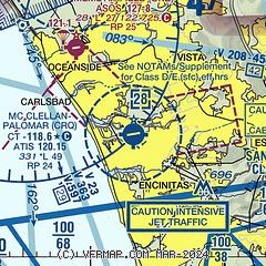
|
CAUTION: Diagram may not be current
 Download PDF
of official airport diagram from the FAA
| Airport distance calculator |
|---|
|
|
| Sunrise and sunset |
|---|
|
Times for 02-Aug-2026
| | Local
(UTC-7) | | Zulu
(UTC) |
|---|
| Morning civil twilight | | 05:37 | | 12:37 |
| Sunrise | | 06:04 | | 13:04 |
| Sunset | | 19:47 | | 02:47 |
| Evening civil twilight | | 20:14 | | 03:14 |
|
| Current date and time |
|---|
| Zulu (UTC) | 02-Aug-2026 20:33:26 |
|---|
| Local (UTC-7) | 02-Aug-2026 13:33:26 |
|---|
|
| METAR |
|---|
| KCRQ | 021953Z 26008KT 230V290 10SM CLR 25/19 A2984 RMK AO2 SLP102 T02500194
|
KOKB
6nm NW | 021952Z AUTO 26011KT 8SM CLR 27/20 A2983 RMK AO2 SLP102 T02670200 $
|
KNFG
10nm N | 021952Z AUTO 10SM 30/19 A2983 RMK AO2 SLP100 T03000194 $
|
KL18
14nm N | 022015Z AUTO 22008KT 10SM CLR 33/17 A2985 RMK AO2
|
KNKX
17nm SE | 021955Z AUTO 24008KT 10SM CLR 30/18 A2985 RMK AO2 SLP102 T03000183 $
|
KRNM
19nm E | 021953Z 28009G17KT 10SM CLR 37/16 A2988 RMK AO2 SLP097 T03670156
|
|
| TAF |
|---|
| KCRQ | 021730Z 0218/0318 24009KT P6SM SKC FM030200 VRB04KT P6SM FEW008 FM030500 VRB03KT P6SM BKN007 FM031600 VRB04KT P6SM SCT010
|
KNFG
10nm N | 021600Z 0216/0322 VRB03KT 9999 OVC006 QNH2989INS BECMG 0216/0218 VRB03KT 9999 SCT010 QNH2984INS FM021930 21009KT 9999 SKC QNH2978INS FM030600 VRB03KT 9999 BKN008 QNH2981INS FM031400 VRB03KT 9999 OVC006 QNH2983INS BECMG 0316/0318 VRB03KT 9999 SCT010 QNH2980INS TX29/0220Z TN19/0308Z
|
KNKX
17nm SE | 021600Z 0216/0322 VRB03KT 6000 BR OVC004 QNH2989INS BECMG 0216/0218 VRB03KT 9999 NSW SCT010 QNH2985INS FM021930 28007KT 9999 SKC QNH2979INS FM030530 VRB03KT 9999 SCT010 QNH2981INS FM030730 VRB03KT 9999 OVC006 QNH2986INS BECMG 0316/0318 VRB03KT 9999 NSW SCT010 QNH2988INS TX30/0222Z TN18/0313Z
|
|
| NOTAMs |
|---|
NOTAMs are issued by the DoD/FAA and will open in a separate window not controlled by AirNav.
|
|
FBO, Fuel Providers, and Aircraft Ground Support |
|---|
| | 
Business Name | |
Contact | |
Services / Description | |
Fuel Prices | |
Comments | |
|---|
 |
|
ASRI 130.00
760-438-6800
[email] |
|
Your "Home Away From Home" in San Diego!
Nearest to Airport Entrance / Exit, Excellent Concierge Service, Call 760-438-6800 for more details.


|
|
 | | 100LL | Jet A | | FS | | $9.74 | | $10.25 | | Updated 28-Jul-2026 |
|
|

1 read write
|
|
 |
|
ASRI 131.175
760-930-0123
[web site]
[email] |
|
Atlantic Aviation is your premier aviation service provider with more than 100 locations in North America, including Hawaii and the Caribbean. We provide standard ground services you'd expect, with a detailed focus on ensuring an unforgettable customer experience.
|
|
 | | 100LL | Jet A | SAF | | FS | | $10.30 | | $10.90 | | $12.12 | | Updated 02-Aug-2026 |
|
|
write
|
|
 |
|
ASRI 131.30
760-891-2800
[web site]
[email] |
|
Come visit us at Carlsbad Jet Center, located at McClellan-Palomar Airport (KCRQ) in Carlsbad, CA. Nestled within Southern California's picturesque resort region, our location offers convenient access to stunning beaches, championship golf courses, bustling business centers, and the magic of LEGOLAND. As an independently owned and operated FBO, Carlsbad Jet Center is driven by a commitment to safety, efficiency, and providing every customer with a first-class VIP experience. Our passion for aviation shines through in everything we do. We can't wait to welcome you! Call or visit us today!


|
|
|
|
1 read write
|
|
| Civic Helicopters |
|
760-438-8424
toll-free 866-438-4354
[web site]
[email] |
|
Aviation fuel, Hangars, Flight training, Aircraft rental, Aerial tours / aerial sightseeing, Aircraft charters, Aerial photography, Aircraft maintenance, Aircraft parts, ...
|
|
| independent | | 100LL | Jet A | | FS | | $7.46 | | $6.95 | | Updated 23-Jul-2026 |
|
|
write
|
|
Alternatives at nearby airports
IMPORTANT: Note that the FBOs below are NOT at KCRQ but at other nearby airports. Do not expect services from these FBOs to be available at KCRQ. |
 |
|
ASRI 130.35
858-800-3878
[web site]
[email] |
|
At KMYF (Montgomery-Gibbs Executive Airport), 20 miles SSE
COAST AIR CENTER - WE PRICE MATCH CAA PRICING
Come visit San Diego's newest Jet Center! We are the most competitively priced FBO in San Diego. We will price match our fuel if you have a better deal at KCRQ, including CAA. Our central location and easy freeway access can have your clients to their destination within 15 minutes. Come enjoy a warm cookie, gourmet espresso beverage and our exceptional service.
|
|
|
|

11 read write
|
|

|
| |
Aviation Businesses, Services, and Facilities |
|---|
| |
Business Name | |
Contact | |
Services / Description | |
Distance | |
Comments | |
|---|
|
|
|
toll-free 888-359-5638
760-476-0890
[web site]
[email] |
|
LOFT is a full-service FAR Part 142 Flight Training Center specializing in CE-525, CE-525S, and CE-500 Initial Type Ratings and Recurrent Training. Offering simulator-based training in a FAA certified Level C CJ1 full flight simulator and in-aircraft training programs, LOFT is the perfect choice.

|
|
on airport |
|
write
|
|
|
|
|
toll-free 877-723-5937
[web site]
[email] |
|
Pacific Coast Flyers is a premier flying club and aviation community. We provide top quality and well equipped aircraft as well as access to flight instruction in a fun and safe atmosphere. We focus on providing the best flying experience possible.
|
|
on airport |
|
write
|
|
| Leading Edge Aviation |
|
760-931-8565
|
|
no information available
If you are affiliated with Leading Edge Aviation and would like to show here your services, contact info, web link, logo, and more, click here
|
|
on airport |
|
write
|
|
| |
Would you like to see your business listed on this page? |
|---|
| | If your business provides an interesting product or service to pilots, flight crews, aircraft, or users of the Mc Clellan-Palomar Airport, you should consider listing it here. To start the listing process, click on the button below

|


