FAA INFORMATION EFFECTIVE 30 OCTOBER 2025
Location
| FAA Identifier: | OWI |
| Lat/Long: | 38-32-21.0273N 095-15-11.4646W
38-32.350455N 095-15.191077W
38.5391742,-95.2531846
(estimated) |
| Elevation: | 966.4 ft. / 294.6 m (surveyed) |
| Variation: | 04E (2000) |
| From city: | 4 miles S of OTTAWA, KS |
| Time zone: | UTC -6 (UTC -5 during Daylight Saving Time) |
| Zip code: | 66067 |
Airport Operations
| Airport use: | Open to the public |
| Activation date: | 04/1946 |
| Control tower: | no |
| ARTCC: | KANSAS CITY CENTER |
| FSS: | WICHITA FLIGHT SERVICE STATION |
| NOTAMs facility: | ICT (NOTAM-D service available) |
| Attendance: | TUES - SAT 0800 - 1400 |
| Wind indicator: | lighted |
| Segmented circle: | yes |
| Lights: | ACTVT REILS RWY 17 & 35; PAPI RWY 17 & 35 - CTAF. MIRL RWY 17/35 PRESET ON LOW INTST TO INCR INTST - CTAF. |
| Beacon: | white-green (lighted land airport)
Operates sunset to sunrise. |
Airport Communications
| CTAF/UNICOM: | 122.8 |
| WX AWOS-3PT: | 118.25 (785-242-2185) |
- APCH/DEP CTL SVC PRVDD BY KANSAS CITY ARTCC (ZKC) ON FREQS 127.725/270.25 (EMPORIA RCAG).
Nearby radio navigation aids
| VOR radial/distance | | VOR name | | Freq | | Var |
|---|
| TOPr154/38.4 | | TOPEKA VORTAC | | 117.80 | | 05E |
| BUMr287/39.4 | | BUTLER VORTAC | | 115.90 | | 07E |
Airport Services
| Fuel available: | 100LL JET-A |
| Parking: | hangars and tiedowns |
| Airframe service: | NONE |
| Powerplant service: | NONE |
| Bottled oxygen: | NONE |
| Bulk oxygen: | NONE |
Runway Information
Runway 17/35
| Dimensions: | 4500 x 75 ft. / 1372 x 23 m |
| Surface: | concrete, in good condition |
| Weight bearing capacity: | | PCN 11 /R/C/X/U | | Single wheel: | 30.0 | | Double wheel: | 30.0 |
|
| Runway edge lights: | medium intensity |
| RUNWAY 17 | | RUNWAY 35 |
| Latitude: | 38-32.738768N | | 38-31.997588N |
| Longitude: | 095-15.145178W | | 095-15.141962W |
| Elevation: | 964.4 ft. | | 964.1 ft. |
| Traffic pattern: | right | | left |
| Runway heading: | 176 magnetic, 180 true | | 356 magnetic, 360 true |
| Markings: | nonprecision, in good condition | | nonprecision, in good condition |
| Visual slope indicator: | 2-light PAPI on left (3.25 degrees glide path) | | 2-light PAPI on left (3.25 degrees glide path) |
| Runway end identifier lights: | yes | | yes |
| Touchdown point: | yes, no lights | | yes, no lights |
| Obstructions: | 65 ft. tree, 1171 ft. from runway, 462 ft. right of centerline, 14:1 slope to clear | | none |
Runway 13/31
| Dimensions: | 1550 x 95 ft. / 472 x 29 m |
| Surface: | turf, in good condition |
| Runway edge markings: | RWY 13/31 MKD OR DELINEATED WITH WHITE BUCKETS. |
| RUNWAY 13 | | RUNWAY 31 |
| Latitude: | 38-32.381500N | | 38-32.216500N |
| Longitude: | 095-15.453000W | | 095-15.205000W |
| Elevation: | 963.1 ft. | | 957.4 ft. |
| Traffic pattern: | right | | left |
| Runway heading: | 127 magnetic, 131 true | | 307 magnetic, 311 true |
| Touchdown point: | yes, no lights | | yes, no lights |
| Obstructions: | 22 ft. tree, 778 ft. from runway, 21 ft. right of centerline, 35:1 slope to clear | | 44 ft. pole, 1089 ft. from runway, 11 ft. right of centerline, 24:1 slope to clear |
Airport Ownership and Management from official FAA records
| Ownership: | Publicly-owned |
| Owner: | CITY OF OTTAWA
POST OFFICE BOX 60
OTTAWA, KS 66067
Phone 785-229-3630 |
| Manager: | JIM REEDER
2178 MONTANA RD
OTTAWA, KS 66067
Phone 785-242-5310 |
Additional Remarks
| - | ULTRALIGHT ACTIVITY ON & INVOF ARPT. |
| - | FBO SVCS NOT AVBL EASTER, THANKSGIVING AND CHRISTMAS DAY. |
| - | +75 FT POLES 1700 FT N OF AER 17 MKD W/RED LGTS. PLINE MKD W/RED BALLS. |
| - | WILDLIFE ON & INVOF ARPT |
| - | FOR CD CTC KANSAS CITY ARTCC AT 913-254-8508. |
Instrument Procedures
NOTE: All procedures below are presented as PDF files. If you need a reader for these files, you should download the free Adobe Reader.NOT FOR NAVIGATION. Please procure official charts for flight.
FAA instrument procedures published for use from 30 October 2025 at 0901Z to 27 November 2025 at 0900Z.
IAPs - Instrument Approach Procedures |
|---|
| RNAV (GPS) RWY 17 | |
download (224KB) |
| RNAV (GPS) RWY 35 | |
download (201KB) |
| NOTE: Special Alternate Minimums apply | |
download (55KB) |
| NOTE: Special Take-Off Minimums/Departure Procedures apply | |
download (356KB) |
Other nearby airports with instrument procedures:
K81 - Miami County Airport (16 nm E)
KIXD - New Century AirCenter Airport (24 nm NE)
KUKL - Coffey County Airport (26 nm SW)
KLWC - Lawrence Regional Airport (28 nm N)
KOJC - Johnson County Executive Airport (30 nm NE)
|
|

Road maps at:
MapQuest
Bing
Google
| Aerial photo |
|---|
WARNING: Photo may not be current or correct
 Photo taken 24-Aug-2013
looking north.
Photo taken 24-Aug-2013
looking north.
Do you have a better or more recent aerial photo of Ottawa Municipal Airport that you would like to share? If so, please send us your photo.
|
| Sectional chart |
|---|
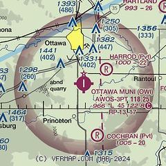
|
| Airport distance calculator |
|---|
|
|
| Sunrise and sunset |
|---|
|
Times for 05-Nov-2025
| | Local
(UTC-6) | | Zulu
(UTC) |
|---|
| Morning civil twilight | | 06:25 | | 12:25 |
| Sunrise | | 06:53 | | 12:53 |
| Sunset | | 17:16 | | 23:16 |
| Evening civil twilight | | 17:44 | | 23:44 |
|
| Current date and time |
|---|
| Zulu (UTC) | 06-Nov-2025 03:05:12 |
|---|
| Local (UTC-6) | 05-Nov-2025 21:05:12 |
|---|
|
| METAR |
|---|
| KOWI | 060235Z AUTO 04004KT 10SM CLR 07/04 A3022 RMK AO2
|
|
| TAF |
|---|
KIXD
24nm NE | 051721Z 0518/0618 36012G22KT P6SM SKC FM052200 03007KT P6SM SKC FM060400 06007KT P6SM SKC FM060700 10006KT P6SM SKC FM061500 15012G19KT P6SM FEW200
|
|
| NOTAMs |
|---|
NOTAMs are issued by the DoD/FAA and will open in a separate window not controlled by AirNav.
|
|

