FAA INFORMATION EFFECTIVE 14 MAY 2026
Location
| FAA Identifier: | PSM |
| Lat/Long: | 43-04-40.6000N 070-49-23.8000W
43-04.676667N 070-49.396667W
43.0779444,-70.8232778
(estimated) |
| Elevation: | 100.4 ft. / 30.6 m (surveyed) |
| Variation: | 16W (2005) |
| From city: | 1 mile W of PORTSMOUTH, NH |
| Time zone: | UTC -4 (UTC -5 during Standard Time) |
| Zip code: | 03801 |
Airport Operations
| Airport use: | Open to the public |
| Activation date: | 01/1946 |
| Control tower: | yes |
| ARTCC: | BOSTON CENTER |
| FSS: | BANGOR FLIGHT SERVICE STATION |
| NOTAMs facility: | PSM (NOTAM-D service available) |
| Attendance: | CONTINUOUS |
| Wind indicator: | lighted |
| Segmented circle: | no |
| Beacon: | white-green (lighted land airport)
Operates sunset to sunrise. |
| Fire and rescue: | ARFF index B |
| Airline operations: | INDEX E ARFF CAPABILITY AVBL 24/7. |
| International operations: | customs landing rights airport |
Airport Communications
| UNICOM: | 122.95 |
| ATIS: | 132.05 273.5 |
| PORTSMOUTH GROUND: | 120.95 275.8 |
| PORTSMOUTH TOWER: | 128.4 269.0 |
| BOSTON APPROACH: | 125.05 |
| BOSTON DEPARTURE: | 125.05 125.05 291.0 395.8 |
| CLEARANCE DELIVERY: | 335.8 |
| ANG OPS: | 141.95 323.8 |
| EMERG: | 121.5 243.0 |
| GCA: | 227.125 |
| IC: | 125.05 |
| WX ASOS at DAW (13 nm N): | 135.275 (603-332-7814) |
| WX AWOS-3PT at SFM (20 nm N): | 120.025 (207-324-1958) |
- TA31 ASR/PAR OPERATED BY ANG DURING ANG OPERATIONS.
- GCA - OPR 1300-2200Z++ MON-FRI OR BY NOTAM. 127.05 227.125
Nearby radio navigation aids
| VOR radial/distance | | VOR name | | Freq | | Var |
|---|
| ENEr221/22.8 | | KENNEBUNK VOR/DME | | 117.10 | | 17W |
| CONr119/34.0 | | CONCORD VOR/DME | | 112.90 | | 15W |
| NDB name | | Hdg/Dist | | Freq | | Var | | ID |
|---|
| ROLLINS | | 195/8.5 | | 260 | | 16W | | ESG | . ... --. |
Airport Services
| Fuel available: | 100LL JET-A J8
J8:AVBL AT ANG 603-430-2459. |
| Parking: | hangars and tiedowns |
| Airframe service: | MAJOR |
| Powerplant service: | MAJOR |
| Bottled oxygen: | HIGH/LOW |
Runway Information
Runway 16/34
| Dimensions: | 11322 x 150 ft. / 3451 x 46 m |
| Surface: | asphalt/concrete/grooved, in good condition
RWY 16-FST 600 FT CONC-GROOVED. |
| Weight bearing capacity: | | Single wheel: | 120.0 | | Double wheel: | 250.0 | | Double tandem: | 550.0 | | Dual double tandem: | 1120.0 |
|
| Runway edge lights: | high intensity
EDGE LGTS ARE 24 IN TALL; 85 FT FM CNTRLN. |
| Runway edge markings: | 16/34 DBL FACED DIST MKRS BOTH SIDES OF RWY AT 1000 FT INTVLS. |
| RUNWAY 16 | | RUNWAY 34 |
| Latitude: | 43-05.476668N | | 43-03.877908N |
| Longitude: | 070-50.049970W | | 070-48.743318W |
| Elevation: | 94.1 ft. | | 84.3 ft. |
| Traffic pattern: | right | | left |
| Runway heading: | 165 magnetic, 149 true | | 345 magnetic, 329 true |
| Displaced threshold: | 803 ft. | | no |
| Declared distances: | TORA:11321 TODA:11321 ASDA:11321 LDA:10518 | | TORA:11321 TODA:11321 ASDA:11321 LDA:11321 |
| Markings: | precision, in good condition | | precision, in good condition |
| Visual slope indicator: | 4-light PAPI on left (3.00 degrees glide path) | | 4-light PAPI on left (3.00 degrees glide path) |
| RVR equipment: | touchdown | | touchdown |
| Approach lights: | MALSR: 1,400 foot medium intensity approach lighting system with runway alignment indicator lights | | MALSR: 1,400 foot medium intensity approach lighting system with runway alignment indicator lights |
| Touchdown point: | yes, no lights | | yes, no lights |
| Instrument approach: | ILS | | ILS |
| Obstructions: | 58 ft. trees, 2200 ft. from runway, 34:1 slope to clear
50:1 TO DTHR. | | none |
Airport Ownership and Management from official FAA records
| Ownership: | Publicly-owned |
| Owner: | PEASE DEVELOPMENT AUTHORITY
55 INTERNATIONAL DR
PORTSMOUTH, NH 03801
Phone 603-433-6536 |
| Manager: | JOHN MEEHAN
36 AIRLINE DR
PORTSMOUTH, NH 03801
Phone 603-766-9238 |
Additional Remarks
| A39-16/34 | PCR VALUE: 430/F/A/X/T |
| - | ON DEP MNTN RWY HDG TO 1100 FT MSL OR END OF RWY (WHICHEVER OCCURS LAST) PRIOR TO TURNING. |
| - | 200 FT BLAST PAD EACH RWY END. |
| - | LITTLEBROOK AIRPARK LCTD 052 DEG 4.4 NM; TFC PAT 1130 FT MSL. FLY DOWNWIND LEG NO CLOSER THAN 1/2 MI FM RWY. |
| - | NO 180 DEG TURNS FOR ACFT OVER 12500 LBS GWT ON ASPH PORTION OF RWY 16/34. |
| - | CUST 24X7X365 CUST CLEARING AVBL. STD OFC HRS MON THRU FRI 0900-1630. CUST MUST BE ARNGD IN ADVN AT 603-422-0910. INT'L ARRS MUST ARNG FOR GND HANDLING PRIOR TO ARR. FBO 603-430-1111/128.825 ARINC. |
| - | RWY 34 IS PREFERRED WHEN TAILWIND CMPT IS LESS THAN FIVE KTS. RWY 16 IS PREFERRED FOR TKOF, BTN 2200-0659, WHEN TAILWIND CMPT IS FIVE KTS OR LESS. |
| - | ALL INBD ACFT WITH HAZUS CARGO INFO CALL ATCT 60 NM OUT. |
| - | MILITARY: ANG: CTN: BASH PHASE II IN EFF MAR THRU MAY & SEP THRU OCT ANNUALLY. BASH MITIGATION PRO IN PLACE. CTC PEASE TWR FOR CURRENT BWC. |
| - | CAUTION: HGT GROUP 1 WCH 54 FT. |
| - | TURB APCH END RWY 34 IN STRONG X WINDS. |
| - | MILITARY OIL: RQR 48 HR PROCESSING TIME. |
| - | AFLD MGMT HRS 1200-0400++ MON-THU, 1200-2100++ FRI, CLSD SAT-SUN, AND HOL EXC UNIT TRNG. ALL TRAN ACFT RQR PPR NLT 72 HR. CTC AFLD MGMT DSN 852-2458 OR 2407. PPR RQRD OUTSIDE PUBLD HRS, CTC COMD POST DSN 852-2459, C603-430-2459. CTC PACK CONTROL 323.8, 30 MIN PRIOR TO LDG. AFLD MGMT DOES NOT STORE COMSEC, CTC COMD POST FOR TEMPO STORAGE. DEICING AVBL, ANTI-ICE AVBL AT FBO. |
| - | NO PLA OR TGL 2300-0700 FOR LCL-BASED ACFT, 2100-0700 FOR TSNT ACFT OR BFR 1200 SUN FOR ALL ACFT. |
| - | BIRDS ON AND INVOF ARPT. |
| - | NOISE SENSITIVE AREAS OFF BOTH ENDS OF RWY. |
| - | TFC PAT: RECTANGULAR 1600 FT MSL OVD 2100 FT MSL - LGT ACFT 1100 FT MSL. |
| - | ON OTHER THAN A PUBLD IAP--ARRG ACFT SHOULD ESTAB THEMSELVES ON FINAL APCH AT LEAST 2 NM FM THE RWY THR AT A MIN OF 700 FT MSL. |
| - | AVOID CLOSE IN BASE LEGS/SHORT APCHS. |
Instrument Procedures
NOTE: All procedures below are presented as PDF files. If you need a reader for these files, you should download the free Adobe Reader.NOT FOR NAVIGATION. Please procure official charts for flight.
FAA instrument procedures published for use from 14 May 2026 at 0901Z to 11 June 2026 at 0900Z.
IAPs - Instrument Approach Procedures |
|---|
| ILS OR LOC RWY 16 | |
download (322KB) |
| ILS OR LOC RWY 34 | |
download (312KB) |
| RNAV (GPS) RWY 16 | |
download (281KB) |
| RNAV (GPS) RWY 34 | |
download (247KB) |
| Radar Approach Procedures available | |
download (144KB) |
| NOTE: Special Alternate Minimums apply | |
download (128KB) |
Departure Procedures |
|---|
| PEASE FOUR | |
download (198KB) |
| TANKER THREE | |
download (159KB) |
| NOTE: Special Take-Off Minimums/Departure Procedures apply | |
download (178KB) |
Other nearby airports with instrument procedures:
3B4 - Seacoast Airfield (4 nm NE)
KDAW - Skyhaven Airport (13 nm N)
KSFM - Sanford Seacoast Regional Airport (20 nm N)
KLWM - Lawrence Municipal Airport (25 nm SW)
B19 - Biddeford Municipal Airport (28 nm NE)
|
|

Road maps at:
MapQuest
Bing
Google
| Aerial photo |
|---|
WARNING: Photo may not be current or correct
 Photo taken 31-Mar-2018
at 2800 feet looking north.
Photo taken 31-Mar-2018
at 2800 feet looking north.
Do you have a better or more recent aerial photo of Portsmouth International Airport at Pease that you would like to share? If so, please send us your photo.
|
| Sectional chart |
|---|
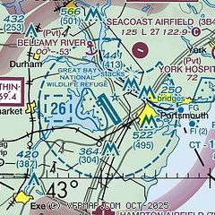
|
 Download PDF
of official airport diagram from the FAA
| Airport distance calculator |
|---|
|
|
| Sunrise and sunset |
|---|
|
Times for 24-May-2026
| | Local
(UTC-4) | | Zulu
(UTC) |
|---|
| Morning civil twilight | | 04:39 | | 08:39 |
| Sunrise | | 05:13 | | 09:13 |
| Sunset | | 20:08 | | 00:08 |
| Evening civil twilight | | 20:41 | | 00:41 |
|
| Current date and time |
|---|
| Zulu (UTC) | 24-May-2026 05:10:26 |
|---|
| Local (UTC-4) | 24-May-2026 01:10:26 |
|---|
|
| METAR |
|---|
| KPSM | 240455Z 09004KT 10SM FEW150 OVC200 12/08 A3051 RMK AO2A SLP334 T01160077 401640072
|
KDAW
13nm N | 240451Z AUTO 00000KT 10SM CLR 10/05 A3052 RMK AO2 SLP333 T01000050 401780056 $
|
KSFM
19nm N | 240456Z AUTO 00000KT 10SM CLR 08/07 A3054 RMK AO2 SLP345 T00830067
|
|
| TAF |
|---|
| KPSM | 231725Z 2318/2418 10011KT P6SM FEW130 OVC250 FM232200 VRB04KT P6SM OVC220 FM240000 00000KT P6SM OVC220 FM241200 VRB04KT P6SM OVC080 PROB30 2412/2414 -SHRA OVC070 FM241400 VRB05KT 5SM -RA BR SCT015 OVC060
|
|
| NOTAMs |
|---|
NOTAMs are issued by the DoD/FAA and will open in a separate window not controlled by AirNav.
|
|


