FAA INFORMATION EFFECTIVE 09 JULY 2026
Location
| FAA Identifier: | PVD |
| Lat/Long: | 41-43-20.4000N 071-25-39.8000W
41-43.340000N 071-25.663333W
41.7223333,-71.4277222
(estimated) |
| Elevation: | 54 ft. / 16.5 m (surveyed) |
| Variation: | 15W (1985) |
| From city: | 6 miles S of PROVIDENCE, RI |
| Time zone: | UTC -4 (UTC -5 during Standard Time) |
| Zip code: | 02886 |
Airport Operations
| Airport use: | Open to the public |
| Activation date: | 09/1937 |
| Control tower: | yes |
| ARTCC: | BOSTON CENTER |
| FSS: | BRIDGEPORT FLIGHT SERVICE STATION |
| NOTAMs facility: | PVD (NOTAM-D service available) |
| Attendance: | CONTINUOUS |
| Wind indicator: | lighted |
| Segmented circle: | yes |
| Lights: | WHEN ATCT CLSD, ALSF-2 BCMS SSALS PRESET MED INTST ONLY. WHEN ATCT CLSD, ACTVT MALSR RWY 23 & 34; REIL RWY 16; PAPI RWY 05, 16 & 34; VASI RWY 23; TDZ RWY 05; CNTLN RWY 5/23; HIRL RWY 5/23 & 16/34 - CTAF. |
| Beacon: | white-green (lighted land airport)
Operates sunset to sunrise. |
| Landing fee: | yes |
| Fire and rescue: | ARFF index C |
| International operations: | customs landing rights airport |
Airport Communications
| CTAF: | 120.7 |
| WX ASOS: | 124.2 (401-734-2818) |
| PROVIDENCE GROUND: | 121.9 348.6 [SUN-FRI 0530-0030 SAT 0530-0000] |
| PROVIDENCE TOWER: | 120.7 257.8 [SUN-FRI 0530-0030 SAT 0530-0000] |
| PROVIDENCE APPROACH: | 123.675 244.875 [SUN-FRI 0530-0030 SAT 0530-0000] |
| PROVIDENCE DEPARTURE: | 123.675 244.875 [SUN-FRI 0530-0030 SAT 0530-0000] |
| CLEARANCE DELIVERY: | 126.65 348.6 |
| CLASS C: | 123.675 244.875 |
| COMD POST: | 383.3 |
| D-ATIS: | 124.2 |
| EMERG: | 121.5 243.0 |
| IC: | 123.675 |
| WIPOR STAR: | 123.675 244.875 |
| WX AWOS-3PT at OQU (8 nm S): | PHONE 401-294-2197 |
| WX AWOS-3PT at SFZ (12 nm N): | 120.775 (401-334-0324) |
| WX ASOS at UUU (13 nm SE): | 132.075 (401-846-5910) |
| WX AWOS-3PT at 1B9 (20 nm NE): | 118.675 (774-372-2047) |
- APCH/DEP SVC PRVDD BY BOSTON ARTCC ON FREQS 124.85/307.9 (WOODSTOCK RCAG) WHEN APCH CTL CLSD.
- ASDE-X IN USE. OPERATE TRANSPONDERS WITH ALTITUDE REPORTING MODE AND ADS-B (IF EQUIPPED) ENABLED ON ALL AIRPORT SURFACES.
Nearby radio navigation aids
| VOR radial/distance | | VOR name | | Freq | | Var |
|---|
| PVD at field | | PROVIDENCE VOR/DME | | 115.60 | | 14W |
| PUTr141/23.3 | | PUTNAM VOR/DME | | 117.40 | | 14W |
| ORWr083/27.5 | | NORWICH VOR/DME | | 110.00 | | 14W |
| SEYr026/34.0 | | SANDY POINT VOR/DME | | 117.80 | | 15W |
| GONr064/36.6 | | GROTON VOR/DME | | 110.85 | | 14W |
Airport Services
| Fuel available: | 100LL JET-A |
| Parking: | hangars and tiedowns |
| Airframe service: | MAJOR |
| Powerplant service: | MAJOR |
| Bottled oxygen: | NONE |
| Bulk oxygen: | NONE |
Runway Information
Runway 5/23
| Dimensions: | 8700 x 150 ft. / 2652 x 46 m |
| Surface: | asphalt/grooved, in fair condition |
| Weight bearing capacity: | | Single wheel: | 120.0 | | Double wheel: | 250.0 | | Double tandem: | 550.0 | | Dual double tandem: | 1120.0 |
|
| Runway edge lights: | high intensity |
| RUNWAY 5 | | RUNWAY 23 |
| Latitude: | 41-42.615697N | | 41-43.828312N |
| Longitude: | 071-26.276960W | | 071-25.258860W |
| Elevation: | 52.9 ft. | | 44.3 ft. |
| Traffic pattern: | left | | left |
| Runway heading: | 047 magnetic, 032 true | | 227 magnetic, 212 true |
| Declared distances: | TORA:8700 TODA:8700 ASDA:8700 LDA:8700 | | TORA:8700 TODA:8700 ASDA:8700 LDA:8700 |
| Markings: | precision, in good condition | | precision, in good condition |
| Visual slope indicator: | 4-light PAPI on right (3.00 degrees glide path) | | 4-box VASI on left (3.00 degrees glide path) |
| RVR equipment: | touchdown, midfield, rollout | | touchdown, midfield, rollout |
| Approach lights: | ALSF2: standard 2,400 foot high intensity approach lighting system with centerline sequenced flashers (category II or III) | | MALSR: 1,400 foot medium intensity approach lighting system with runway alignment indicator lights |
| Runway end identifier lights: | no | | no |
| Centerline lights: | yes | | yes |
| Touchdown point: | yes, lighted | | yes, no lights |
| Instrument approach: | ILS/DME | | ILS/DME |
| Obstructions: | 56 ft. trees, 2475 ft. from runway, 600 ft. right of centerline, 40:1 slope to clear | | 50 ft. trees, 2185 ft. from runway, 790 ft. right of centerline, 39:1 slope to clear |
Runway 16/34
| Dimensions: | 6081 x 150 ft. / 1853 x 46 m |
| Surface: | asphalt/grooved, in good condition |
| Weight bearing capacity: | | Single wheel: | 120.0 | | Double wheel: | 250.0 | | Double tandem: | 423.0 | | Dual double tandem: | 1093.0 |
|
| Runway edge lights: | high intensity |
| RUNWAY 16 | | RUNWAY 34 |
| Latitude: | 41-43.899263N | | 41-43.114760N |
| Longitude: | 071-25.930487W | | 071-25.099945W |
| Elevation: | 53.7 ft. | | 32.8 ft. |
| Traffic pattern: | left | | left |
| Runway heading: | 157 magnetic, 142 true | | 337 magnetic, 322 true |
| Displaced threshold: | 565 ft. | | no |
| Declared distances: | TORA:6081 TODA:6081 ASDA:6081 LDA:5516 | | TORA:6081 TODA:6081 ASDA:6081 LDA:6081 |
| Markings: | precision, in good condition | | precision, in good condition |
| Visual slope indicator: | 4-light PAPI on left (3.00 degrees glide path) | | 4-light PAPI on left (3.00 degrees glide path) |
| RVR equipment: | rollout | | touchdown |
| Approach lights: | | | MALSR: 1,400 foot medium intensity approach lighting system with runway alignment indicator lights |
| Runway end identifier lights: | yes | | no |
| Touchdown point: | yes, no lights | | yes, no lights |
| Instrument approach: | | | ILS/DME |
| Obstructions: | 19 ft. pole, 560 ft. from runway, 200 ft. left of centerline, 18:1 slope to clear
54 FT TREES 700 FT R OF CNTRLN 2000 FT FM RWY END. 37:1 TO DTHR. | | 39 ft. trees, 1400 ft. from runway, 300 ft. right of centerline, 30:1 slope to clear |
Airport Ownership and Management from official FAA records
| Ownership: | Publicly-owned |
| Owner: | STATE OF RHODE ISLAND
RI AIRPORT CORP, 2000 POST RD
WARWICK, RI 02886
Phone 401-691-2000 |
| Manager: | IFTIKHAR AHMAD
RI AIRPORT CORP, 2000 POST RD
WARWICK, RI 02886
Phone 401-691-2000 |
Additional Remarks
| A39-05/23 | PCR VALUE: 1010/F/A/X/T |
| A39-16/34 | PCR VALUE: 780/F/B/X/T |
| E60-34 | ENGINEERED MATERIAL ARRESTING SYSTEM (EMAS) 255 FT IN LENGTH BY 170 FT IN WIDTH LCTD AT THE DER 34. |
| E60-23 | ENGINEERED MATERIAL ARRESTING SYSTEM (EMAS) 417 FT IN LENGTH BY 178 FT IN WIDTH LCTD AT THE DER 23. |
| E60-16 | ENGINEERED MATERIAL ARRESTING SYSTEM (EMAS) 462 FT IN LENGTH BY 178 FT IN WIDTH LCTD AT THE DER 16. |
| - | GND VEHICLES MNT CTAF WHEN ATCT CLSD. |
| - | TRML RAMP PROHIBITED FOR USE BY GA. |
| - | TWY V CLSD DLY 2000-0800 BTN RWY 16/34 AND TWY C. |
| - | PARKED ACFT ON THE NE RAMP WEST OF TWY A, BE ALERT. FQT FLT SCHOOL, TSNT JET ACFT, AND VER ACTVTY. |
| - | NE RAMP ACFT WITH WINGSPAN GTR THAN 150 FT RQR GND CREW ASSISTANCE FOR THRU TAXI AND PRKG. |
| - | FOR CD WHEN APCH CLSD CTC BOSTON ARTCC AT 603-879-6859. |
| - | DEER & BIRDS ON & INVOF ARPT. |
| - | TWY A UNEVEN PAVEMENT BTN TWY M & RWY 23. |
| - | 110 FT UNMKD LGT POLES, 2700 FT FM THR RWY 34, 900 FT LEFT OF CNTRLN. |
| - | RUN UP PAD FOR TWY F CLSD TO ACFT WITH WINGSPAN OVER 118 FT. |
| - | NOISE ABATEMENT PROCS IN EFCT. HELS AVOID RESL AREAS WHEN BLW 1000 FT. |
| - | NW RAMP ACFT WITH WINGSPAN GTR THAN 110 FT RQR GND CREW ASSISTANCE FOR THRU TAXI AND PRKG. |
Instrument Procedures
NOTE: All procedures below are presented as PDF files. If you need a reader for these files, you should download the free Adobe Reader.NOT FOR NAVIGATION. Please procure official charts for flight.
FAA instrument procedures published for use from 09 July 2026 at 0901Z to 06 August 2026 at 0900Z.
STARs - Standard Terminal Arrivals |
|---|
| JORDN TWO (RNAV) **NEW** | |
download (115KB) |
| WIPOR FOUR (RNAV) **NEW** | |
download (284KB) |
IAPs - Instrument Approach Procedures |
|---|
| ILS OR LOC RWY 05 | |
download (298KB) |
| ILS OR LOC RWY 23 | |
download (295KB) |
| ILS OR LOC RWY 34 | |
download (310KB) |
| ILS RWY 23 (SA CAT I - II) | |
download (270KB) |
| ILS RWY 05 (CAT II - III) | |
download (248KB) |
| RNAV (RNP) Z RWY 23 | |
download (248KB) |
| RNAV (GPS) RWY 05 | |
download (264KB) |
| RNAV (GPS) RWY 16 | |
download (219KB) |
| RNAV (GPS) RWY 34 | |
download (300KB) |
| RNAV (GPS) Y RWY 23 | |
download (247KB) |
| VOR RWY 05 | |
download (304KB) |
| NOTE: Special Alternate Minimums apply | |
download (150KB) |
| NOTE: Special Take-Off Minimums/Departure Procedures apply | |
download (488KB) |
Other nearby airports with instrument procedures:
KOQU - Quonset State Airport (8 nm S)
KSFZ - North Central State Airport (12 nm N)
KUUU - Newport State Airport (13 nm SE)
1B9 - Mansfield Municipal Airport (20 nm NE)
KTAN - Taunton Municipal Airport/King Field (21 nm NE)
|
|

Road maps at:
MapQuest
Bing
Google
| Aerial photo |
|---|
WARNING: Photo may not be current or correct
 Photo taken 21-Dec-2018
looking north.
Photo taken 21-Dec-2018
looking north.
Do you have a better or more recent aerial photo of Rhode Island TF Green International Airport that you would like to share? If so, please send us your photo.
|
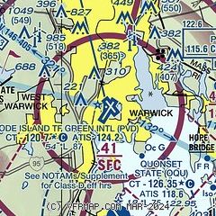
| Sectional chart |
|---|
|
 Download PDF
of official airport diagram from the FAA
| Airport distance calculator |
|---|
|
|
| Sunrise and sunset |
|---|
|
Times for 26-Jul-2026
| | Local
(UTC-4) | | Zulu
(UTC) |
|---|
| Morning civil twilight | | 05:03 | | 09:03 |
| Sunrise | | 05:35 | | 09:35 |
| Sunset | | 20:09 | | 00:09 |
| Evening civil twilight | | 20:41 | | 00:41 |
|
| Current date and time |
|---|
| Zulu (UTC) | 26-Jul-2026 17:59:08 |
|---|
| Local (UTC-4) | 26-Jul-2026 13:59:08 |
|---|
|
| METAR |
|---|
| KPVD | 261751Z 05010G18KT 10SM SCT075 SCT200 26/10 A2989 RMK AO2 SLP119 T02610100 10261 20183 56015
|
KOQU
7nm S | 261650Z 02011KT 10SM CLR 25/12 A2987
|
KSFZ
12nm N | 261656Z AUTO 05008KT 10SM CLR 24/11 A2992 RMK AO2 SLP129 T02440106 $
|
|
| TAF |
|---|
| KPVD | 261432Z 2615/2712 03011KT P6SM SCT060 FM262300 06006KT P6SM SCT250 FM270500 34003KT P6SM SCT250
|
|
| NOTAMs |
|---|
NOTAMs are issued by the DoD/FAA and will open in a separate window not controlled by AirNav.
|
|


