FAA INFORMATION EFFECTIVE 19 FEBRUARY 2026
Location
| FAA Identifier: | RMY |
| Lat/Long: | 42-15-04.2954N 084-57-19.5995W
42-15.071590N 084-57.326658W
42.2511932,-84.9554443
(estimated) |
| Elevation: | 941.2 ft. / 286.9 m (surveyed) |
| Variation: | 05W (1995) |
| From city: | 1 mile S of MARSHALL, MI |
| Time zone: | UTC -5 (UTC -4 during Daylight Saving Time) |
| Zip code: | 49068 |
Airport Operations
| Airport use: | Open to the public |
| Activation date: | 04/1940 |
| Control tower: | no |
| ARTCC: | CHICAGO CENTER |
| FSS: | LANSING FLIGHT SERVICE STATION |
| NOTAMs facility: | RMY (NOTAM-D service available) |
| Attendance: | 0800-DUSK
EXC MAJOR HOLS. |
| Pattern altitude: | 1941.2 ft. MSL |
| Wind indicator: | lighted |
| Segmented circle: | yes |
| Lights: | ACTVT PAPI RWY 10 & 28; MIRL RWY 10/28; NSTD PERIMETER LGTS HELIPAD H1 - CTAF. |
| Beacon: | white-green (lighted land airport)
Operates sunset to sunrise. |
Airport Communications
| CTAF/UNICOM: | 122.8 |
| WX AWOS-3: | 120.025 (269-781-9070) |
| GREAT LAKES APPROACH: | 119.2 |
| GREAT LAKES DEPARTURE: | 119.2 |
| WX ASOS at BTL (13 nm W): | PHONE 269-964-0283 |
| WX AWOS-3P at OEB (20 nm S): | 118.125 (517-279-1810) |
- APCH/DEP SVC PRVDD BY CHICAGO ARTCC ON FREQS 127.55/307.175 (GOSHEN RCAG) WHEN GREAT LAKES APCH CTL CLSD.
Nearby radio navigation aids
| NDB name | | Hdg/Dist | | Freq | | Var | | ID |
|---|
| BATOL | | 127/12.1 | | 272 | | 04W | | BT | -... - |
| STURGIS | | 043/33.8 | | 382 | | 04W | | IRS | .. .-. ... |
Airport Services
| Fuel available: | 100LL UL94 |
| Parking: | hangars and tiedowns |
| Airframe service: | MAJOR |
| Powerplant service: | MAJOR |
Runway Information
Runway 10/28
| Dimensions: | 3501 x 75 ft. / 1067 x 23 m |
| Surface: | asphalt, in good condition |
| Weight bearing capacity: | |
| Runway edge lights: | medium intensity |
| RUNWAY 10 | | RUNWAY 28 |
| Latitude: | 42-15.104820N | | 42-15.038360N |
| Longitude: | 084-57.711998W | | 084-56.941317W |
| Elevation: | 938.8 ft. | | 936.6 ft. |
| Traffic pattern: | left | | left |
| Runway heading: | 102 magnetic, 097 true | | 282 magnetic, 277 true |
| Markings: | nonprecision, in good condition | | nonprecision, in good condition |
| Visual slope indicator: | 4-light PAPI on left (4.00 degrees glide path) | | 4-light PAPI on right (4.00 degrees glide path) |
| Runway end identifier lights: | no | | |
| Touchdown point: | yes, no lights | | yes, no lights |
| Obstructions: | none
ALSO +15 FT ROAD, 520 FT DIST, 0 FT B, APCH RATIO 21:1. | | 40 ft. trees, 640 ft. from runway, 217 ft. right of centerline, 11:1 slope to clear |
Helipad H1
| Dimensions: | 100 x 100 ft. / 30 x 30 m |
| Surface: | concrete, in good condition |
| Weight bearing capacity: | |
| Runway edge lights: | non-standard
NSTD PERIMETER LGTS DUE TO COLOR. |
| Latitude: | 42-15.192333N | | |
| Longitude: | 084-57.675333W | | |
| Elevation: | 940.0 ft. | | |
| Traffic pattern: | left | | left |
| Markings: | , in good condition | | |
Airport Ownership and Management from official FAA records
| Ownership: | Publicly-owned |
| Owner: | CITY OF MARSHALL, MI
TOWN HALL, 323 W MICHIGAN AVE
MARSHALL, MI 49068-1547
Phone 269-781-4447 |
| Manager: | CRAIG GRISWOLD
TOWN HALL, 323 W MICHIGAN AVE
MARSHALL, MI 49068-1547
Phone 269-330-2908 |
Additional Remarks
| A52-H1 | 24 FT WINDSOCK ON POLE, 195 FT NE. |
| - | DEER & LRG BIRDS ON & INVOF ARPT. |
| - | 150 FT LGTD WATER TWR 3000 FT S OF HELIPAD. |
| - | ADMIN BLDG ACES, PRESS 5-3-2-1. |
| - | FOR CD CTC GREAT LAKES APCH AT 269-459-3344, WHEN APCH CLSD CTC CHICAGO ARTCC AT 630-906-8921. |
| - | FOR SNOW REMOVAL HELIPAD H1 CALL AMGR. |
| - | GLIDER & ULTRALIGHT ACTVTY ON & INVOF ARPT, SUMMER MOS. |
| - | ULTRALIGHT ACFT FLY LEFT HAND PATTERN 500 FT AGL, S OF RY 10/28. |
Instrument Procedures
NOTE: All procedures below are presented as PDF files. If you need a reader for these files, you should download the free Adobe Reader.NOT FOR NAVIGATION. Please procure official charts for flight.
FAA instrument procedures published for use from 19 February 2026 at 0901Z to 19 March 2026 at 0900Z.
IAPs - Instrument Approach Procedures |
|---|
| RNAV (GPS) RWY 28 | |
download (212KB) |
| NOTE: Special Alternate Minimums apply | |
download (135KB) |
| NOTE: Special Take-Off Minimums/Departure Procedures apply | |
download (347KB) |
Other nearby airports with instrument procedures:
KBTL - Battle Creek Executive Airport at Kellogg Field (13 nm W)
KOEB - Branch County Memorial Airport (20 nm S)
KFPK - Fitch H Beach Airport (20 nm N)
KJXN - Jackson County Airport/Reynolds Field (22 nm E)
KJYM - Hillsdale Municipal Airport (26 nm SE)
|
|

Road maps at:
MapQuest
Bing
Google
| Aerial photo |
|---|
WARNING: Photo may not be current or correct
 Taken early September 2008
taken from the east looking west.
Taken early September 2008
taken from the east looking west.
Do you have a better or more recent aerial photo of Brooks Field Airport that you would like to share? If so, please send us your photo.
|
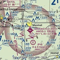
| Sectional chart |
|---|
|
| Airport distance calculator |
|---|
|
|
| Sunrise and sunset |
|---|
|
Times for 17-Mar-2026
| | Local
(UTC-4) | | Zulu
(UTC) |
|---|
| Morning civil twilight | | 07:21 | | 11:21 |
| Sunrise | | 07:49 | | 11:49 |
| Sunset | | 19:47 | | 23:47 |
| Evening civil twilight | | 20:15 | | 00:15 |
|
| Current date and time |
|---|
| Zulu (UTC) | 17-Mar-2026 04:14:55 |
|---|
| Local (UTC-4) | 17-Mar-2026 00:14:55 |
|---|
|
| METAR |
|---|
| KRMY | 170355Z AUTO 31009G21KT 280V340 10SM BKN037 OVC045 M06/M13 A2975 RMK AO2 T10621131
|
KBTL
13nm W | 170353Z AUTO 31012G23KT 10SM BKN031 OVC038 M07/M12 A2975 RMK AO2 SNB10E19B37E43 SLP089 P0000 T10671122
|
KFPK
20nm N | 170355Z AUTO 31012G21KT 10SM -SN BKN032 OVC040 M07/M13 A2973 RMK AO2 PK WND 32029/58 400971070
|
|
| TAF |
|---|
KBTL
13nm W | 170155Z 1702/1724 31015G26KT P6SM -SHSN BKN050 TEMPO 1702/1704 5SM -SHSN BR OVC030 FM170800 30014G24KT P6SM VCSH BKN035 FM171500 30010G18KT P6SM -SHSN BKN035 FM172000 29012G20KT P6SM BKN050
|
|
| NOTAMs |
|---|
NOTAMs are issued by the DoD/FAA and will open in a separate window not controlled by AirNav.
|
|

