FAA INFORMATION EFFECTIVE 16 APRIL 2026
Location
| FAA Identifier: | OEB |
| Lat/Long: | 41-56-00.5600N 085-03-08.3100W
41-56.009333N 085-03.138500W
41.9334889,-85.0523083
(estimated) |
| Elevation: | 958.3 ft. / 292.1 m (surveyed) |
| Variation: | 05W (2000) |
| From city: | 3 miles W of COLDWATER, MI |
| Time zone: | UTC -4 (UTC -5 during Standard Time) |
| Zip code: | 49036 |
Airport Operations
| Airport use: | Open to the public |
| Activation date: | 10/1946 |
| Control tower: | no |
| ARTCC: | CHICAGO CENTER |
| FSS: | LANSING FLIGHT SERVICE STATION |
| NOTAMs facility: | OEB (NOTAM-D service available) |
| Attendance: | MON-FRI 0900-1700 |
| Wind indicator: | lighted |
| Segmented circle: | yes |
| Lights: | ACTVT REIL RWY 07 & 25; PAPI RWY 07 & 25; MIRL RWY 07/25 & 04/22 - CTAF. |
| Beacon: | white-green (lighted land airport)
Operates sunset to sunrise. |
Airport Communications
| CTAF/UNICOM: | 122.7 |
| WX AWOS-3P: | 118.125 (517-279-1810) |
| GREAT LAKES APPROACH: | 121.2 |
| GREAT LAKES DEPARTURE: | 121.2 |
| WX AWOS-3 at ANQ (18 nm S): | 118.175 (260-668-5630) |
| WX AWOS-3P at IRS (19 nm SW): | 121.325 (269-659-8715) |
| WX AWOS-3P at RMY (20 nm N): | 120.025 (269-781-9070) |
- APCH/DEP SVC PRVDD BY CHICAGO ARTCC ON 127.55/307.175 (GOSHEN RCAG) WHEN GREAT LAKES APCH CTL CLSD.
Nearby radio navigation aids
| NDB name | | Hdg/Dist | | Freq | | Var | | ID |
|---|
| STURGIS | | 071/18.5 | | 382 | | 04W | | IRS | .. .-. ... |
Airport Services
| Fuel available: | 100LL JET-A+
100LL:FUEL AVBL H24 SELF SVC; FOR ATTENDANT AFT HRS & WKENDS CALL 517-677-1888. |
| Parking: | hangars and tiedowns |
| Airframe service: | MAJOR |
| Powerplant service: | MAJOR |
| Bottled oxygen: | NONE |
| Bulk oxygen: | NONE |
Runway Information
Runway 7/25
| Dimensions: | 5350 x 75 ft. / 1631 x 23 m |
| Surface: | asphalt, in fair condition |
| Weight bearing capacity: | |
| Runway edge lights: | medium intensity |
| RUNWAY 7 | | RUNWAY 25 |
| Latitude: | 41-55.772048N | | 41-56.160242N |
| Longitude: | 085-03.847872W | | 085-02.788965W |
| Elevation: | 956.1 ft. | | 953.3 ft. |
| Traffic pattern: | left | | left |
| Runway heading: | 069 magnetic, 064 true | | 249 magnetic, 244 true |
| Markings: | nonprecision, in good condition | | nonprecision, in good condition |
| Visual slope indicator: | 2-light PAPI on left (3.00 degrees glide path) | | 2-light PAPI on left (3.00 degrees glide path) |
| Runway end identifier lights: | yes | | yes |
| Touchdown point: | yes, no lights | | yes, no lights |
| Obstructions: | 40 ft. tree, 1003 ft. from runway, 316 ft. left of centerline, 20:1 slope to clear | | 15 ft. road, lighted, 383 ft. from runway, 268 ft. left of centerline, 12:1 slope to clear |
Runway 4/22
| Dimensions: | 3500 x 75 ft. / 1067 x 23 m |
| Surface: | asphalt, in excellent condition |
| Weight bearing capacity: | |
| Runway edge lights: | medium intensity |
| RUNWAY 4 | | RUNWAY 22 |
| Latitude: | 41-55.860748N | | 41-56.341098N |
| Longitude: | 085-03.101422W | | 085-02.675295W |
| Elevation: | 955.3 ft. | | 954.9 ft. |
| Traffic pattern: | left | | left |
| Runway heading: | 039 magnetic, 034 true | | 219 magnetic, 214 true |
| Markings: | basic, in good condition | | basic, in good condition |
| Touchdown point: | yes, no lights | | yes, no lights |
Runway 16/34
| Dimensions: | 2399 x 190 ft. / 731 x 58 m |
| Surface: | turf, in good condition |
| Runway edge markings: | RWY & DTHR MKD WITH 3 FT YELLOW CONES. |
| RUNWAY 16 | | RUNWAY 34 |
| Latitude: | 41-56.157333N | | 41-55.787000N |
| Longitude: | 085-03.194333W | | 085-03.010167W |
| Elevation: | 954.0 ft. | | 955.0 ft. |
| Traffic pattern: | left | | left |
| Runway heading: | 165 magnetic, 160 true | | 345 magnetic, 340 true |
| Displaced threshold: | 594 ft. | | 194 ft. |
| Runway end identifier lights: | no | | no |
| Touchdown point: | yes, no lights | | yes, no lights |
| Obstructions: | 65 ft. trees, 462 ft. from runway, 143 ft. left of centerline, 7:1 slope to clear
APCH RATIO 16:1 TO DTHR OVR 65 FT TREES, 1056 FT DIST, 143 FT L. | | 71 ft. trees, 1133 ft. from runway, 228 ft. right of centerline, 15:1 slope to clear
APCH RATIO 15:1 TO DTHR OVR 52 FT TREES, 780 FT DIST, 135 FT R. |
Airport Ownership and Management from official FAA records
| Ownership: | Publicly-owned |
| Owner: | BRANCH COUNTY
31 DIVISION ST
COLDWATER, MI 49036-1904
Phone 517-279-4300 |
| Manager: | JOSEPH J BEST
351 AIRPORT DR
COLDWATER, MI 49036-9313
Phone 269-419-9904
AVBL AFT HRS & WKENDS. |
Additional Remarks
| A30A-25 | CALM WIND RWY. |
| - | RWY 16/34 NOT PLOWED, CLSD NOV-MAR. |
| - | BIRDS & DEER ON & INVOF ARPT. |
| - | ADMIN BLDG ACES: 1-2-2-7 (CTAF). |
| - | FOR CD CTC GREAT LAKES APCH AT 269-459-3344, WHEN APCH CLSD CTC CHICAGO ARTCC AT 630-906-8921. |
Instrument Procedures
NOTE: All procedures below are presented as PDF files. If you need a reader for these files, you should download the free Adobe Reader.NOT FOR NAVIGATION. Please procure official charts for flight.
FAA instrument procedures published for use from 16 April 2026 at 0901Z to 14 May 2026 at 0900Z.
IAPs - Instrument Approach Procedures |
|---|
| RNAV (GPS) RWY 07 **CHANGED** | |
download (248KB) |
| RNAV (GPS) RWY 25 **CHANGED** | |
download (245KB) |
| NOTE: Special Alternate Minimums apply | |
download (135KB) |
| NOTE: Special Take-Off Minimums/Departure Procedures apply | |
download (328KB) |
Other nearby airports with instrument procedures:
KANQ - Tri-State Steuben County Airport (18 nm S)
KIRS - Kirsch Municipal Airport (19 nm SW)
KRMY - Brooks Field Airport (20 nm N)
KJYM - Hillsdale Municipal Airport (21 nm E)
KBTL - Battle Creek Executive Airport at Kellogg Field (24 nm N)
|
|

Road maps at:
MapQuest
Bing
Google
| Aerial photo |
|---|
WARNING: Photo may not be current or correct
 Photo by Richard Lawrence
Photo taken 13-Apr-2010
from an Angel Flight at 9,000 ft.
Photo by Richard Lawrence
Photo taken 13-Apr-2010
from an Angel Flight at 9,000 ft.
Do you have a better or more recent aerial photo of Branch County Memorial Airport that you would like to share? If so, please send us your photo.
|
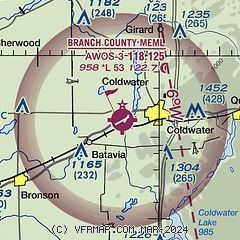
| Sectional chart |
|---|
|
CAUTION: Diagram may not be current

| Airport distance calculator |
|---|
|
|
| Sunrise and sunset |
|---|
|
Times for 10-May-2026
| | Local
(UTC-4) | | Zulu
(UTC) |
|---|
| Morning civil twilight | | 05:55 | | 09:55 |
| Sunrise | | 06:26 | | 10:26 |
| Sunset | | 20:47 | | 00:47 |
| Evening civil twilight | | 21:18 | | 01:18 |
|
| Current date and time |
|---|
| Zulu (UTC) | 10-May-2026 16:35:12 |
|---|
| Local (UTC-4) | 10-May-2026 12:35:12 |
|---|
|
| METAR |
|---|
| KOEB | 101615Z AUTO VRB05KT 10SM FEW075 15/01 A3008 RMK AO2
|
KANQ
18nm S | 101615Z AUTO VRB04G13KT 10SM CLR 15/M03 A3007 RMK AO2
|
KRMY
19nm N | 101615Z AUTO 27010G18KT 10SM CLR 14/M02 A3008 RMK AO2 T01411024
|
KIRS
19nm SW | 101616Z AUTO VRB05KT 10SM FEW075 14/M01 A3008 RMK AO2
|
|
| TAF |
|---|
KBTL
24nm N | 101440Z 1015/1112 31007KT P6SM SKC FM101700 30013G20KT P6SM FEW070 FM102300 29006KT P6SM FEW080 FM110900 03004KT P6SM FEW080
|
KAZO
29nm NW | 101440Z 1015/1112 31007KT P6SM SKC FM101700 30012G19KT P6SM FEW070 FM102300 29006KT P6SM FEW080 FM110900 03004KT P6SM FEW080
|
|
| NOTAMs |
|---|
NOTAMs are issued by the DoD/FAA and will open in a separate window not controlled by AirNav.
|
|


