FAA INFORMATION EFFECTIVE 14 MAY 2026
Location
| FAA Identifier: | ANQ |
| Lat/Long: | 41-38-22.9140N 085-05-00.5760W
41-38.381900N 085-05.009600W
41.6396983,-85.0834933
(estimated) |
| Elevation: | 995 ft. / 303.3 m (surveyed) |
| Variation: | 05W (2000) |
| From city: | 3 miles W of ANGOLA, IN |
| Time zone: | UTC -4 (UTC -5 during Standard Time) |
| Zip code: | 46703 |
Airport Operations
| Airport use: | Open to the public |
| Activation date: | 04/1940 |
| Control tower: | no |
| ARTCC: | CHICAGO CENTER |
| FSS: | TERRE HAUTE FLIGHT SERVICE STATION |
| NOTAMs facility: | HUF (NOTAM-D service available) |
| Attendance: | MAR-NOV MON-SAT 0800-1700, MAR-NOV SUN 1200-1700, DEC-FEB MON-FRI 0800-1700
UNATNDD THANKSGIVING, CHRISTMAS & NEW YEARS. |
| Wind indicator: | lighted |
| Segmented circle: | no |
| Lights: | ACTVT REIL RWY 05 & 23; MIRL RWY 05/23 - CTAF. DUSK-0000 MIRL RWY 05/23 PRESET LOW INTST; INCR INTST - CTAF. |
| Beacon: | white-green (lighted land airport)
Operates sunset to sunrise. |
Airport Communications
| CTAF/UNICOM: | 123.075 |
| WX AWOS-3: | 118.175 (260-668-5630) |
| FORT WAYNE APPROACH: | 127.2 ;SW/NW OF ACTIVE RWY 132.15 ;SE/NE OF ACTIVE RWY |
| FORT WAYNE DEPARTURE: | 127.2 ;SW/NW OF ACTIVE RWY 132.15 ;SE/NE OF ACTIVE RWY |
| WX AWOS-3P at C62 (13 nm SW): | 119.925 (260-347-2967) |
| WX AWOS-3P at OEB (18 nm N): | 118.125 (517-279-1810) |
| WX AWOS-3P at IRS (19 nm NW): | 121.325 (269-659-8715) |
| WX AWOS-3P at GWB (20 nm S): | 124.15 (260-925-8225) |
Nearby radio navigation aids
| VOR radial/distance | | VOR name | | Freq | | Var |
|---|
| OLKr041/(30.0) | | WEBSTER LAKE VOR | | 110.40 | | 03W |
| FWAr013/39.9 | | FORT WAYNE VORTAC | | 117.80 | | 06W |
| NDB name | | Hdg/Dist | | Freq | | Var | | ID |
|---|
| STURGIS | | 128/18.8 | | 382 | | 04W | | IRS | .. .-. ... |
Airport Services
| Fuel available: | 100LL JET-A |
| Parking: | hangars and tiedowns |
Runway Information
Runway 5/23
| Dimensions: | 4540 x 75 ft. / 1384 x 23 m |
| Surface: | asphalt/grooved, in excellent condition |
| Weight bearing capacity: | |
| Runway edge lights: | medium intensity |
| Operational restrictions: | 260 FT UNLGTD STWY SW END. |
| RUNWAY 5 | | RUNWAY 23 |
| Latitude: | 41-38.127163N | | 41-38.636772N |
| Longitude: | 085-05.373058W | | 085-04.644008W |
| Elevation: | 986.1 ft. | | 994.8 ft. |
| Traffic pattern: | left | | left |
| Runway heading: | 052 magnetic, 047 true | | 232 magnetic, 227 true |
| Displaced threshold: | 540 ft. | | no |
| Declared distances: | TORA:4540 TODA:4540 ASDA:4540 LDA:4000 | | TORA:4000 TODA:4000 ASDA:4000 LDA:4000 |
| Markings: | nonprecision, in good condition | | nonprecision, in fair condition |
| Visual slope indicator: | 2-light PAPI on left (3.00 degrees glide path) | | 2-light PAPI on left (4.00 degrees glide path) |
| Runway end identifier lights: | yes | | yes |
| Touchdown point: | yes, no lights | | yes, no lights |
| Obstructions: | 15 ft. road, 200 ft. from runway, 205 ft. right of centerline
15 FT ROAD 200 FT FM RWY END 205 FT R. | | 73 ft. trees, 860 ft. from runway, 280 ft. right of centerline, 9:1 slope to clear |
Airport Ownership and Management from official FAA records
| Ownership: | Publicly-owned |
| Owner: | STEUBEN CO BOAC
5220 W. U.S. 20
ANGOLA, IN 46703-9680
Phone (260) 665-7111 |
| Manager: | AARON PAYONK
5220 W. U.S. 20
ANGOLA, IN 46703-9680
Phone 260-316-3711 |
Additional Remarks
| - | PAJA & BIRDS ON & INVOF ARPT; DEER SS-SR. |
| - | COND UNMNT 1700-0800, WKEND & HOL. |
| - | FOR CD CTC CHICAGO ARTCC AT 630-906-8921. |
Instrument Procedures
NOTE: All procedures below are presented as PDF files. If you need a reader for these files, you should download the free Adobe Reader.NOT FOR NAVIGATION. Please procure official charts for flight.
FAA instrument procedures published for use from 14 May 2026 at 0901Z to 11 June 2026 at 0900Z.
IAPs - Instrument Approach Procedures |
|---|
| RNAV (GPS) RWY 05 | |
download (188KB) |
| RNAV (GPS) RWY 23 | |
download (170KB) |
| NOTE: Special Take-Off Minimums/Departure Procedures apply | |
download (459KB) |
Other nearby airports with instrument procedures:
C62 - Kendallville Municipal Airport (13 nm SW)
KOEB - Branch County Memorial Airport (18 nm N)
KIRS - Kirsch Municipal Airport (19 nm NW)
KGWB - Auburn/Dekalb Executive Airport (20 nm S)
0G6 - Williams County Airport (28 nm E)
|
|

Road maps at:
MapQuest
Bing
Google
| Aerial photo |
|---|
WARNING: Photo may not be current or correct
 Photo courtesy of Stemen Stock Photos
Taken in April 2006
Photo courtesy of Stemen Stock Photos
Taken in April 2006
Do you have a better or more recent aerial photo of Tri-State Steuben County Airport that you would like to share? If so, please send us your photo.
|
| Sectional chart |
|---|
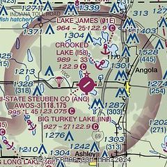
|
| Airport distance calculator |
|---|
|
|
| Sunrise and sunset |
|---|
|
Times for 07-Jun-2026
| | Local
(UTC-4) | | Zulu
(UTC) |
|---|
| Morning civil twilight | | 05:33 | | 09:33 |
| Sunrise | | 06:07 | | 10:07 |
| Sunset | | 21:11 | | 01:11 |
| Evening civil twilight | | 21:45 | | 01:45 |
|
| Current date and time |
|---|
| Zulu (UTC) | 07-Jun-2026 20:13:20 |
|---|
| Local (UTC-4) | 07-Jun-2026 16:13:20 |
|---|
|
| METAR |
|---|
| KANQ | 071955Z AUTO 08006KT 10SM CLR 29/13 A2998 RMK AO2
|
KC62
13nm SW | 071935Z AUTO 16004KT 10SM CLR 27/16 A3000 RMK AO2 T02770163
|
KOEB
17nm N | 071956Z AUTO VRB03KT 10SM CLR 29/11 A2999 RMK AO2
|
KIRS
18nm NW | 071956Z AUTO 08002KT 10SM CLR 29/13 A2998 RMK AO2
|
KGWB
20nm S | 071955Z AUTO 09007KT 1 3/4SM -DZ HZ SCT085 30/16 A2996 RMK AO2 VIS 1/2V5
|
|
| TAF |
|---|
KFWA
41nm S | 071720Z 0718/0818 07008KT P6SM SCT100 BKN250 FM081100 12010KT P6SM OVC080
|
KBTL
41nm N | 071740Z 0718/0818 06004KT P6SM SKC FM081000 13009KT P6SM SCT100 SCT250
|
KAZO
41nm NW | 071740Z 0718/0818 06004KT P6SM SKC FM081000 13009KT P6SM SCT100 SCT250
|
KJXN
47nm NE | 071740Z 0718/0818 07005KT P6SM SKC FM081000 13007KT P6SM SCT100 SCT250
|
|
| NOTAMs |
|---|
NOTAMs are issued by the DoD/FAA and will open in a separate window not controlled by AirNav.
|
|

