FAA INFORMATION EFFECTIVE 14 MAY 2026
Location
| FAA Identifier: | SKA |
| Lat/Long: | 47-36-54.2000N 117-39-20.9000W
47-36.903333N 117-39.348333W
47.6150556,-117.6558056
(estimated) |
| Elevation: | 2462.2 ft. / 750 m (estimated) |
| Variation: | 16E (2010) |
| From city: | 10 miles SW of SPOKANE, WA |
| Time zone: | UTC -7 (UTC -8 during Standard Time) |
| Zip code: | 99011 |
Airport Operations
| Airport use: | Private use. Permission required prior to landing |
| Activation date: | 12/1948 |
| Control tower: | yes |
| ARTCC: | SEATTLE CENTER |
| FSS: | SEATTLE FLIGHT SERVICE STATION |
| NOTAMs facility: | SKA (NOTAM-D service available) |
| Attendance: | CONTINUOUS |
| Pattern altitude: | RECTANGULAR 4000 FT, OVERHEAD 4500 FT. |
| Segmented circle: | no |
| Beacon: | white-green (lighted land airport)
Operates sunset to sunrise. |
| International operations: | international airport of entry |
Airport Communications
| ATIS: | 257.625 |
| FAIRCHILD GROUND: | 123.6 275.8 |
| FAIRCHILD TOWER: | 120.35 233.7 |
| SPOKANE APPROACH: | 123.75 ;205-025 133.35 ;026-204 |
| SPOKANE DEPARTURE: | 123.75 ;205-025 133.35 ;026-204 316.7 |
| CLASS C: | 123.75 ;205-025 133.35 ;026-204 |
| COMD POST: | 311.0 ;CALL STRIKEHAWK 321.0 ;CALL STRIKEHAWK |
| EMERG: | 121.5 243.0 |
| HILIE STAR: | 133.35 |
| IC: | 123.75 ;205-025 |
| OPS: | 293.7 |
| PMSV METRO: | 234.8 |
| PTD: | 139.3 372.2 |
| ZOOMR STAR: | 123.75 |
| WX ASOS at GEG (5 nm E): | PHONE 509-742-2544 |
| WX ASOS at SFF (14 nm E): | 120.55 (509-535-3290) |
- AREA C IS SE OF A LINE CONNECTING ROCK LAKE, CHENEY, FELTS FIELD & THE SOUTH SIDE OF MICA PEAK 6000/BLO. USE FREQS 124.7/263.0 IN AREA C ABOVE 6000.
- SFA.
Nearby radio navigation aids
| VOR radial/distance | | VOR name | | Freq | | Var |
|---|
| GEGr325/3.2 | | SPOKANE VORTAC | | 115.50 | | 14E |
| COEr235/35.0 | | COEUR D'ALENE VOR/DME | | 108.80 | | 19E |
| NDB name | | Hdg/Dist | | Freq | | Var | | ID |
|---|
| DEER PARK | | 188/23.1 | | 365 | | 16E | | DPY | -.. .--. -.-- |
Airport Services
| Airframe service: | MAJOR |
| Powerplant service: | MAJOR |
| Bottled oxygen: | NONE |
| Bulk oxygen: | LOW |
Runway Information
Runway 5/23
| Dimensions: | 13899 x 150 ft. / 4236 x 46 m |
| Surface: | concrete/grooved |
| Weight bearing capacity: | |
| Runway edge lights: | high intensity |
| RUNWAY 5 | | RUNWAY 23 |
| Latitude: | 47-36.451500N | | 47-37.355000N |
| Longitude: | 117-40.901000W | | 117-37.795167W |
| Elevation: | 2462.2 ft. | | 2415.2 ft. |
| Traffic pattern: | left | | right |
| Runway heading: | 050 magnetic, 066 true | | 230 magnetic, 246 true |
| Markings: | precision, in good condition | | precision, in good condition |
| Visual slope indicator: | 4-light PAPI on left (3.00 degrees glide path) | | 4-light PAPI on left (3.00 degrees glide path) |
| RVR equipment: | touchdown | | touchdown |
| Approach lights: | ALSF2: standard 2,400 foot high intensity approach lighting system with centerline sequenced flashers (category II or III) | | ALSF1: standard 2,400 foot high intensity approach lighting system with centerline sequenced flashers (category I) |
| Runway end identifier lights: | no | | no |
| Centerline lights: | yes | | yes |
| Touchdown point: | yes, no lights | | yes, no lights |
| Instrument approach: | LOC/GS | | LOC/GS |
Airport Ownership and Management from official FAA records
| Ownership: | U.S. Air Force |
| Owner: | USAF
HEADQUARTERS 92 BOMB WING
FAIRCHILD AFB, WA 99011 |
| Manager: | BASE OPERATIONS
HEADQUARTERS 92 BOMB WING
FAIRCHILD AFB, WA 99011
Phone 509-247-5481 |
Additional Remarks
| - | JASU: (MA-1A) (A/M32A-86) (MC-1A). |
| - | FUEL: J8, A++ |
| - | FLUID: SP PRESAIR; DE-ICE AVBL FOR C5 AND C17 TYPE ACFT; LOX. |
| - | OIL: O-148-156 JOAP. |
| - | RSTD: PPR INCL SKED AMC MSN, 24 HR PRIOR COORD REQ. ALL INBND PAX/CARGO ACFT MUST CTC COMD POST NO LATER THAN 30 MIN PRIOR TO LDG. |
| - | RSTD: AMC ACFT OPR RSTD DUR BIRD WATCH COND MODERATE (TKOF OR LDG PERMS ONLY WHEN DEP/ARR RTE AVOID IDENT BIRD ACT, NO LCL IFR/VFR TFC PAT ACT) AND SEVERE (TKOF AND LDG PROH WO OG/CC APVL), CTC PTD OR COMD POST FOR CURRENT BIRD WATCH COND. |
| - | CAUTION: DO NOT MISTAKE SPOKANE INTL 4.5 NM E OF FAIRCHILD AFB. PHASE II (THE HIGH BIRD POTENTIAL HAZ TIME PERIOD) OF THE BASH PROGRAM IS IN EFFECT. EXP INCREASED BIRD ACT (APPROX) APR-MAY AND NOV-DEC; REVIEW OR CHECK NOTAM FOR CURRENT BASH PHASE. |
| - | ANG: DAGGER OPS IS OPEN 24/7. PPR FOR ANG RAMP, DSN 370-7100/7133. |
| - | SFA REMARKS: ACFT RQR SFA NOTIFY SEATTLE CENTER OR APP 20 MIN OUT ON ANY PUBL FREQ. |
| - | RWY 05/23 ST175 WGT THSD LBS. |
| - | PAD 5 DZ, 5000' S OF RWY EFF 1630-2130Z++ MON-FRI. |
| - | CAUTION: UNCTL VEH ON TWYS AND RAMPS. COPTER OPNS WITHIN VICINITY OF FAIRCHILD AFB. |
| - | TRAN ALERT SVC AVBL 1400-0600Z++, CLSD WKEND. CTC BASE OPS NLT 15 MIN OUT FOR SVC REQ. FLEET SVC AVBL. |
| - | MISC: AIR EVAC/TRAN ACFT CTC PTD NLT 15 MIN PRIOR TO ARR. |
| - | CAUTION: FLARE ROCKET FRNG AND DEMOLITION OF EXPLOSIVES TRNG WED 1530-1630Z++ AND 2000-2100Z++ LCTD 5,000 FT S RY 5-23 ABM TWY F, MAX ALT 1300 FT. |
| - | CSTMS/AG/IMG: C509-247-5202/5439. |
| - | ARFF AVBL UPON REQ. |
| - | AMOPS AVBL TO STORE CLASSIFIED UP TO SECRET LTD STORAGE CAPABILITY. |
| - | RWY COND CODES (RWYCC) UNAVBL. |
| - | PMSV O/S; CTC WX FLT DSN 657-8411, C509-247-8411. WX FLT SVC AVBL H24. AN/FMQ-19 AUTOMATED OBSERVING SYS IN USE; AUGMENTED BY HUMAN OBSN WHEN NEC. |
Instrument Procedures
NOTE: All procedures below are presented as PDF files. If you need a reader for these files, you should download the free Adobe Reader.NOT FOR NAVIGATION. Please procure official charts for flight.
FAA instrument procedures published for use from 14 May 2026 at 0901Z to 11 June 2026 at 0900Z.
STARs - Standard Terminal Arrivals |
|---|
| HILIE THREE | |
download (158KB) |
| ZOOMR TWO | |
download (178KB) |
IAPs - Instrument Approach Procedures |
|---|
| ILS OR LOC RWY 05 | |
download (143KB) |
| ILS OR LOC RWY 23 | |
download (143KB) |
| ILS RWY 05 (CAT II) | |
download (117KB) |
| RNAV (GPS) RWY 05 | |
download (69KB) |
| RNAV (GPS) RWY 23 | |
download (70KB) |
| TACAN RWY 05 | |
download (126KB) |
| TACAN RWY 23 | |
download (126KB) |
| NOTE: Special Take-Off Minimums/Departure Procedures apply | |
download (559KB) |
Other nearby airports with instrument procedures:
KGEG - Spokane International Airport (5 nm E)
KSFF - Felts Field Airport (14 nm E)
KDEW - Deer Park Airport (23 nm NE)
KCOE - Coeur D'Alene Airport (35 nm E)
2S8 - Wilbur Airport (45 nm W)
|
|

Road maps at:
MapQuest
Bing
Google
| Aerial photo |
|---|
WARNING: Photo may not be current or correct
 As seen circa 2006
Do you have a better or more recent aerial photo of Fairchild Air Force Base that you would like to share? If so, please send us your photo.
|
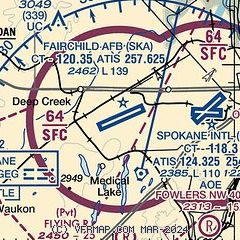
| Sectional chart |
|---|
|
 Download PDF
of official airport diagram from the FAA
| Airport distance calculator |
|---|
|
|
| Sunrise and sunset |
|---|
|
Times for 24-May-2026
| | Local
(UTC-7) | | Zulu
(UTC) |
|---|
| Morning civil twilight | | 04:26 | | 11:26 |
| Sunrise | | 05:04 | | 12:04 |
| Sunset | | 20:31 | | 03:31 |
| Evening civil twilight | | 21:09 | | 04:09 |
|
| Current date and time |
|---|
| Zulu (UTC) | 25-May-2026 03:01:21 |
|---|
| Local (UTC-7) | 24-May-2026 20:01:21 |
|---|
|
| METAR |
|---|
| KSKA | 250155Z AUTO 19006KT 10SM CLR 23/03 A2983 RMK AO2 SLP089 T02260026 $
|
KGEG
5nm E | 250253Z 20006KT 10SM FEW150 BKN200 23/01 A2983 RMK AO2 SLP088 T02280011 56014
|
KSFF
14nm E | 250253Z 19007KT 10SM CLR 23/01 A2982 RMK AO2 SLP086 T02330006 56013
|
|
| TAF |
|---|
| KSKA | 241900Z 2419/2601 22012G22KT 9999 SCT200 QNH2980INS BECMG 2502/2503 17009KT 9999 FEW200 QNH2970INS BECMG 2518/2519 22015G25KT 9999 FEW250 QNH2959INS TX28/2423Z TN10/2512Z
|
KGEG
5nm E | 241736Z 2418/2518 21012G20KT P6SM FEW190 SCT250 FM241900 22017G25KT P6SM FEW090 SCT250 FM250100 21012KT P6SM SKC FM250400 16008KT P6SM SKC
|
KSFF
14nm E | 241736Z 2418/2518 21012G22KT P6SM FEW090 SCT250 FM250200 21007KT P6SM SKC FM250400 04004KT P6SM SKC FM251600 16006KT P6SM SKC
|
|
| NOTAMs |
|---|
NOTAMs are issued by the DoD/FAA and will open in a separate window not controlled by AirNav.
|
|


