FAA INFORMATION EFFECTIVE 14 MAY 2026
Location
| FAA Identifier: | VPC |
| Lat/Long: | 34-07-23.3310N 084-50-55.3440W
34-07.388850N 084-50.922400W
34.1231475,-84.8487067
(estimated) |
| Elevation: | 758.6 ft. / 231.2 m (surveyed) |
| Variation: | 04W (2005) |
| From city: | 3 miles SW of CARTERSVILLE, GA |
| Time zone: | UTC -4 (UTC -5 during Standard Time) |
| Zip code: | 30120 |
Airport Operations
| Airport use: | Open to the public |
| Activation date: | 06/1969 |
| Control tower: | no |
| ARTCC: | ATLANTA CENTER |
| FSS: | MACON FLIGHT SERVICE STATION |
| NOTAMs facility: | VPC (NOTAM-D service available) |
| Attendance: | 0600-2000 |
| Pattern altitude: | 1799.6 ft. MSL
TPA FOR LGT ACFT 1041 FT AGL, TPA FOR JET & TURBOPROP ACFT 1541 FT AGL, TPA FOR ULTRALIGHT ACFT 541 FT AGL. |
| Wind indicator: | lighted |
| Segmented circle: | no |
| Lights: | REIL RWY 19; PAPI RWY 01 & 19; HIRL RWY 01/19 OPER DUSK-2200. AFT 2200 ACTVT - CTAF. |
| Beacon: | white-green (lighted land airport)
Operates sunset to sunrise. |
Airport Communications
| CTAF/UNICOM: | 122.7 |
| WX AWOS-3PT: | 120.525 (770-607-7782) |
| ATLANTA APPROACH: | 121.0 [0645-2300] |
| ATLANTA DEPARTURE: | 121.0 [0645-2300] |
| BOKRT STAR: | 119.8 |
| WRGNZ STAR: | 128.575 |
| WX AWOS-3 at PUJ (13 nm S): | 126.225 (770-445-3870) |
| WX AWOS-3PT at RYY (14 nm SE): | PHONE 770-425-3406 |
Nearby radio navigation aids
| VOR radial/distance | | VOR name | | Freq | | Var |
|---|
| RMGr099/13.6 | | ROME VORTAC | | 115.40 | | 01E |
| NDB name | | Hdg/Dist | | Freq | | Var | | ID |
|---|
| CARROLLTON | | 027/36.3 | | 278 | | 04W | | GPQ | --. .--. --.- |
Airport Services
| Fuel available: | 100LL JET-A+ |
| Parking: | tiedowns |
| Airframe service: | MAJOR |
| Powerplant service: | MAJOR |
| Bottled oxygen: | NONE |
| Bulk oxygen: | NONE |
Runway Information
Runway 1/19
| Dimensions: | 5760 x 100 ft. / 1756 x 30 m |
| Surface: | asphalt/grooved, in excellent condition |
| Weight bearing capacity: | |
| Runway edge lights: | high intensity |
| RUNWAY 1 | | RUNWAY 19 |
| Latitude: | 34-06.914910N | | 34-07.862783N |
| Longitude: | 084-50.957098W | | 084-50.887682W |
| Elevation: | 758.6 ft. | | 730.7 ft. |
| Traffic pattern: | left | | left |
| Runway heading: | 007 magnetic, 003 true | | 187 magnetic, 183 true |
| Displaced threshold: | 740 ft. | | no |
| Markings: | nonprecision, in good condition | | nonprecision, in good condition |
| Visual slope indicator: | 2-light PAPI on left (3.00 degrees glide path) | | 2-light PAPI on left (3.00 degrees glide path) |
| Runway end identifier lights: | | | yes |
| Touchdown point: | yes, no lights | | yes, no lights |
| Instrument approach: | | | LOC/DME |
| Obstructions: | 93 ft. trees, 1324 ft. from runway, 121 ft. left of centerline, 12:1 slope to clear
APCH SLP IS 17:1 TO DSPLCD THLD, 130 FT TREES 2275 FT OUT AND 403 FT LEFT. | | 41 ft. trees, 476 ft. from runway, 283 ft. right of centerline, 6:1 slope to clear |
Airport Ownership and Management from official FAA records
| Ownership: | Publicly-owned |
| Owner: | CITY OF CARTERSVILLE
PO BOX 1390
CARTERSVILLE, GA 30120
Phone 770-387-5672 |
| Manager: | FREDDY MORGAN
PO BOX 1390
CARTERSVILLE, GA 30120
Phone 770-387-5672
FBO PHONE NR 770-382-9800. |
Additional Remarks
| - | FOR APCH/DEP SVC CTC ATLANTA APCH AT 678-364-6131. |
| - | FOR CD CTC ATLANTA APCH AT 678-364-6131. |
| - | ULTRALIGHT/LSA ACT ON AND INVOF ARPT. |
| - | DEER ON & INVOF ARPT. |
| - | ULTRALIGHT/LSA TFC PAT INSIDE NORMAL PAT WITH CENTRAL THIRD OF RWY 01/19 DSGND ULTRALIGHT/LSA LNDG & TKOF AREA. ULTRALIGHT/LSA PAT ENTRY CROSSES FIELD APRXLY 2000 FT FROM EITHER APCH END AT 541 FT AGL. |
| - | GRASS STRIP 4.9 NM NW OF ARPT. |
| - | RWY/TWY SEPN APPROX 200 FT. SOUTH END TWY/PARKED ACFT SEPN APPROX 75 FT. |
| - | RAMP FEES FOR TURBINE ACFT. |
Instrument Procedures
NOTE: All procedures below are presented as PDF files. If you need a reader for these files, you should download the free Adobe Reader.NOT FOR NAVIGATION. Please procure official charts for flight.
FAA instrument procedures published for use from 14 May 2026 at 0901Z to 11 June 2026 at 0900Z.
STARs - Standard Terminal Arrivals |
|---|
| BOKRT THREE (RNAV) | |
download (186KB) |
| BUKHD THREE (RNAV) | |
download (190KB) |
| DEHAN THREE (RNAV) | |
2 pages:
[1] [2] (326KB) |
| SWTEE TWO (RNAV) | |
download (142KB) |
| WRGNZ THREE (RNAV) | |
download (245KB) |
IAPs - Instrument Approach Procedures |
|---|
| RNAV (GPS) RWY 01 | |
download (226KB) |
| RNAV (GPS) RWY 19 | |
download (229KB) |
| VOR-A | |
download (192KB) |
| NOTE: Special Alternate Minimums apply | |
download (154KB) |
| NOTE: Special Take-Off Minimums/Departure Procedures apply | |
download (189KB) |
Other nearby airports with instrument procedures:
KPUJ - Paulding Northwest Atlanta Airport (13 nm S)
KRYY - Cobb County International Airport-McCollum Field (14 nm SE)
4A4 - Polk County Airport/Cornelius Moore Field (16 nm SW)
KCZL - Tom B David Field Airport (20 nm N)
KRMG - Richard B. Russell Regional Airport - J.H. Towers Field (21 nm NW)
|
|

Road maps at:
MapQuest
Bing
Google
| Aerial photo |
|---|
WARNING: Photo may not be current or correct
 Photo courtesy of AirNav, LLC
Photo taken 04-May-2014
looking southwest.
Photo courtesy of AirNav, LLC
Photo taken 04-May-2014
looking southwest.
Do you have a better or more recent aerial photo of Cartersville Airport that you would like to share? If so, please send us your photo.
|
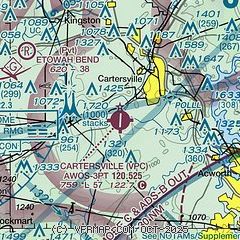
| Sectional chart |
|---|
|
| Airport distance calculator |
|---|
|
|
| Sunrise and sunset |
|---|
|
Times for 10-Jun-2026
| | Local
(UTC-4) | | Zulu
(UTC) |
|---|
| Morning civil twilight | | 05:59 | | 09:59 |
| Sunrise | | 06:28 | | 10:28 |
| Sunset | | 20:49 | | 00:49 |
| Evening civil twilight | | 21:18 | | 01:18 |
|
| Current date and time |
|---|
| Zulu (UTC) | 10-Jun-2026 12:32:05 |
|---|
| Local (UTC-4) | 10-Jun-2026 08:32:05 |
|---|
|
| METAR |
|---|
| KVPC | 101215Z AUTO 00000KT 10SM SCT050 24/23 A3014 RMK AO2
|
KPUJ
13nm S | 101215Z AUTO 17003KT 1SM BR BKN001 OVC044 21/21 A3014 RMK AO2 VIS 1/2V3
|
KRYY
14nm SE | 101151Z 00000KT 7SM FEW002 BKN043 BKN075 22/22 A3015 RMK AO2 $
|
|
| TAF |
|---|
KRYY
14nm SE | 101124Z 1012/1112 00000KT 5SM BR SCT003 BKN040 FM101400 24004KT P6SM SCT035 SCT070 FM110100 21003KT P6SM FEW050 SCT250
|
|
| NOTAMs |
|---|
NOTAMs are issued by the DoD/FAA and will open in a separate window not controlled by AirNav.
|
|


