FAA INFORMATION EFFECTIVE 27 NOVEMBER 2025
Location
| FAA Identifier: | SAC |
| Lat/Long: | 38-30-46.3000N 121-29-35.8810W
38-30.771667N 121-29.598017W
38.5128611,-121.4933003
(estimated) |
| Elevation: | 23.6 ft. / 7.2 m (surveyed) |
| Variation: | 14E (2010) |
| From city: | 3 miles S of SACRAMENTO, CA |
| Time zone: | UTC -8 (UTC -7 during Daylight Saving Time) |
| Zip code: | 95822 |
Airport Operations
| Airport use: | Open to the public |
| Activation date: | 04/1940 |
| Control tower: | yes |
| ARTCC: | OAKLAND CENTER |
| FSS: | RANCHO MURIETA FLIGHT SERVICE STATION |
| NOTAMs facility: | SAC (NOTAM-D service available) |
| Attendance: | 0800-1600 |
| Pattern altitude: | TPA 1000' EXCP 1500' FOR TURBINE & LARGE ACFT. |
| Wind indicator: | lighted |
| Segmented circle: | yes |
| Lights: | DUSK-DAWN. WHEN ATCT CLSD ACTVT ALL AIRFIELD LGTS - CTAF. |
| Beacon: | white-green (lighted land airport)
DUSK-DAWN. WHEN ATCT CLSD ACTVT APT BCN - CTAF |
Airport Communications
| CTAF: | 119.5 |
| UNICOM: | 122.95 |
| ATIS: | 118.075 |
| WX ASOS: | PHONE 916-421-0923 |
| EXEC GROUND: | 125.0 [0600-2100] |
| EXEC TOWER: | 119.5 278.8 [0600-2100] |
| NORCAL APPROACH: | 125.25 127.4 ;NORTH-EAST |
| NORCAL DEPARTURE: | 125.25 127.4 ;NORTH-EAST |
| IC: | 125.25 |
| WX AWOS-3PT at MHR (10 nm E): | 118.325 (916-366-3371) |
| WX AWOS-3 at MCC (10 nm NE): | 125.975 (916-641-1272) |
| WX ASOS at SMF (12 nm NW): | PHONE 916-649-3996 |
| WX AWOS-3 at EDU (14 nm W): | 119.025 (530-754-6839) |
| WX AWOS-3P at DWA (18 nm W): | 125.775 (530-750-2759) |
Nearby radio navigation aids
| VOR radial/distance | | VOR name | | Freq | | Var |
|---|
| SACr016/5.0 | | SACRAMENTO VORTAC | | 115.20 | | 17E |
| MCCr187/10.2 | | MC CLELLAN VOR/DME | | 109.20 | | 17E |
| LINr302/35.0 | | LINDEN VOR/DME | | 114.80 | | 17E |
| MYVr158/35.3 | | MARYSVILLE VOR/DME | | 110.80 | | 16E |
| HNWr233/37.1 | | HANGTOWN VOR/DME | | 115.50 | | 17E |
| CCRr026/38.3 | | CONCORD VOR/DME | | 117.00 | | 17E |
Airport Services
| Fuel available: | 100LL JET-A |
| Parking: | tiedowns |
| Airframe service: | MAJOR |
| Powerplant service: | MAJOR |
| Bottled oxygen: | HIGH/LOW |
| Bulk oxygen: | HIGH/LOW |
Runway Information
Runway 2/20
| Dimensions: | 5503 x 150 ft. / 1677 x 46 m |
| Surface: | asphalt, in good condition |
| Weight bearing capacity: | | Single wheel: | 60.0 | | Double wheel: | 130.0 | | Double tandem: | 210.0 |
|
| Runway edge lights: | medium intensity |
| RUNWAY 2 | | RUNWAY 20 |
| Latitude: | 38-30.312458N | | 38-31.071783N |
| Longitude: | 121-30.043790W | | 121-29.413298W |
| Elevation: | 17.3 ft. | | 23.5 ft. |
| Traffic pattern: | left | | left |
| Runway heading: | 019 magnetic, 033 true | | 199 magnetic, 213 true |
| Markings: | precision, in good condition | | precision, in good condition |
| Visual slope indicator: | | | 4-light PAPI on left (3.00 degrees glide path) |
| Approach lights: | MALSR: 1,400 foot medium intensity approach lighting system with runway alignment indicator lights | | |
| Runway end identifier lights: | no | | yes |
| Touchdown point: | yes, no lights | | yes, no lights |
| Instrument approach: | ILS | | |
| Obstructions: | 33 ft. tree, 1350 ft. from runway, 275 ft. left and right of centerline, 34:1 slope to clear | | 40 ft. tree, 1430 ft. from runway, 250 ft. right of centerline, 30:1 slope to clear |
Runway 12/30
| Dimensions: | 3837 x 100 ft. / 1170 x 30 m |
| Surface: | asphalt, in good condition |
| Weight bearing capacity: | | Single wheel: | 30.0 | | Double wheel: | 43.0 | | Double tandem: | 67.0 |
|
| Runway edge lights: | medium intensity |
| RUNWAY 12 | | RUNWAY 30 |
| Latitude: | 38-31.101790N | | 38-30.669635N |
| Longitude: | 121-29.704408W | | 121-29.117188W |
| Elevation: | 22.7 ft. | | 23.4 ft. |
| Traffic pattern: | left | | left |
| Runway heading: | 119 magnetic, 133 true | | 299 magnetic, 313 true |
| Markings: | basic, in good condition | | basic, in good condition |
| Visual slope indicator: | 4-light PAPI on left (3.00 degrees glide path) | | 4-light PAPI on left (3.50 degrees glide path) |
| Runway end identifier lights: | yes | | yes |
| Touchdown point: | yes, no lights | | yes, no lights |
| Obstructions: | 40 ft. tree, 1200 ft. from runway, 201 ft. right of centerline, 25:1 slope to clear | | 50 ft. tree, 1050 ft. from runway, 100 ft. left of centerline, 17:1 slope to clear |
Helipad H1
| Dimensions: | 60 x 60 ft. / 18 x 18 m |
| Surface: | asphalt, in good condition |
| Runway edge lights: | PERI |
| Latitude: | 38-30.617833N | | |
| Longitude: | 121-29.943667W | | |
| Elevation: | 19.0 ft. | | |
| Traffic pattern: | left | | left |
Airport Ownership and Management from official FAA records
| Ownership: | Publicly-owned |
| Owner: | CITY OF SACRAMENTO
6151 FREEPORT BLVD.
SACRAMENTO, CA 95322-3518
Phone 916-875-9035
OPERATED BY CO OF SACRAMENTO |
| Manager: | RON OGLE
6151 FREEPORT BLVD
SACRAMENTO, CA 95822
Phone 916-875-9035
APT MGR HRS 0800-1630 M-F |
Additional Remarks
| - | RY 20 CALM WIND RY. |
| - | NO TOUCH & GO LNDGS, LOW APPCHS OR PRACTICE INST APPCHS BTN HRS 2100-0600 LOCAL; FOR MORE INFO CALL (916) 874-0359. |
| - | BIRDS INVOF OF APRT. |
| - | DITCH AND CONCRETE BRIDGE IN RY 02/20 SAFETY AREA LCTD 500 FT PRIOR TO RY 02 THLD ON CL. |
| - | ARPT NOISE ABATEMENT PROCEDURES IN EFFECT 2100-0600 FOR MORE INFO CALL (916) 875-9037 OR (916) 875-9035. |
| - | ARPT 24HR EMERGENCY 916-929-5000. |
| - | PRIOR PERMISSION FROM AIRPORT OPERATOR REQUIRED FOR ACFT OVER 50,000 LBS MAX TAKEOFF WEIGHT. |
| - | DSTC BTN TWY A AND TWY B CNTRLN IS 75 FT. |
| - | RWY 12 BLAST PAD MARKINGS NOT STD. |
| - | FOR CD WHEN ATCT IS CLSD CTC NORCAL APCH AT 916-361-6874. |
| - | GOLF COURSE LGTS SHINE ACROSS RY 02 FINAL APCH 800 FT RY CL DUSK TO 2200. |
| - | NO MID-FIELD, INTERSECTION OR FORMATION TKOFS. |
Instrument Procedures
NOTE: All procedures below are presented as PDF files. If you need a reader for these files, you should download the free Adobe Reader.NOT FOR NAVIGATION. Please procure official charts for flight.
FAA instrument procedures published for use from 27 November 2025 at 0901Z to 25 December 2025 at 0900Z.
IAPs - Instrument Approach Procedures |
|---|
| ILS OR LOC RWY 02 | |
download (255KB) |
| RNAV (GPS) RWY 02 | |
download (235KB) |
| VOR RWY 02 | |
download (188KB) |
| NOTE: Special Alternate Minimums apply | |
download (142KB) |
| NOTE: Special Take-Off Minimums/Departure Procedures apply | |
download (355KB) |
Other nearby airports with instrument procedures:
KMHR - Sacramento Mather Airport (10 nm E)
KMCC - Mc Clellan Airfield (10 nm NE)
KSMF - Sacramento International Airport (12 nm NW)
KEDU - University Airport (14 nm W)
KDWA - Yolo County Airport (18 nm W)
|
|

Road maps at:
MapQuest
Bing
Google
| Aerial photo |
|---|
WARNING: Photo may not be current or correct
 Photo by Jan Sears
Taken in April 2018
from 3000 feet looking north.
Photo by Jan Sears
Taken in April 2018
from 3000 feet looking north.
Do you have a better or more recent aerial photo of Sacramento Executive Airport that you would like to share? If so, please send us your photo.
|
| Sectional chart |
|---|
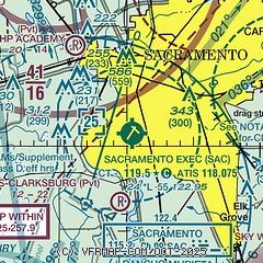
|
 Download PDF
of official airport diagram from the FAA
| Airport distance calculator |
|---|
|
|
| Sunrise and sunset |
|---|
|
Times for 21-Dec-2025
| | Local
(UTC-8) | | Zulu
(UTC) |
|---|
| Morning civil twilight | | 06:51 | | 14:51 |
| Sunrise | | 07:21 | | 15:21 |
| Sunset | | 16:47 | | 00:47 |
| Evening civil twilight | | 17:17 | | 01:17 |
|
| Current date and time |
|---|
| Zulu (UTC) | 22-Dec-2025 06:15:03 |
|---|
| Local (UTC-8) | 21-Dec-2025 22:15:03 |
|---|
|
| METAR |
|---|
| KSAC | 220553Z AUTO 15008KT 4SM -RA BR OVC030 15/13 A2999 RMK AO2 RAB21 SLP154 P0002 60002 T01500128 10172 20150 53010
|
KMHR
10nm E | 220555Z AUTO 22005KT 10SM BKN036 OVC042 15/15 A2999 RMK AO2
|
KMCC
10nm NE | 220555Z AUTO 18013KT 3/4SM -RA BR OVC003 14/14 A2999 RMK AO2 P0009
|
KSMF
12nm NW | 220553Z 17014KT 6SM -RA BR SCT031 OVC036 14/13 A2997 RMK AO2 PK WND 20026/0513 RAB03 SLP149 P0007 60014 T01440128 10167 20144 53011 $
|
KEDU
14nm W | 220555Z AUTO 17009KT 7SM BKN023 OVC032 14/14 A2997 RMK AO1 P0006
|
KDWA
18nm W | 220550Z AUTO 17009G14KT 4SM -RA BR FEW008 BKN020 OVC028 14/14 A2997 RMK AO2
|
|
| TAF |
|---|
| KSAC | 220520Z 2206/2306 16014G20KT P6SM -RA OVC040 FM220900 16013G20KT 4SM RA OVC015 FM221500 16010KT P6SM -RA OVC025 FM221900 17010KT 4SM RA OVC010 FM230000 19005KT 6SM -RA OVC020
|
KMHR
10nm E | 220520Z 2206/2306 14012KT P6SM -RA OVC040 FM220900 16013G20KT 4SM RA OVC015 FM221500 16010KT P6SM -RA OVC025 FM221900 17010KT 4SM RA OVC010 FM230000 19005KT 6SM -RA OVC020
|
KMCC
10nm NE | 220520Z 2206/2306 16009G16KT 5SM -SHRA SCT026 OVC035 FM220800 16013KT 3SM -RA BR OVC015 FM221400 16010KT 4SM -SHRA BR OVC010 FM221800 17010KT 4SM BR OVC015 FM230000 19005KT 6SM -RA OVC020
|
KSMF
12nm NW | 220520Z 2206/2306 16014G25KT P6SM -RA FEW016 OVC028 FM220900 16013G22KT 4SM RA OVC015 FM221500 16010KT P6SM -RA OVC025 FM221900 17010KT 4SM RA OVC010 FM230000 19005KT 6SM -RA OVC020
|
|
| NOTAMs |
|---|
NOTAMs are issued by the DoD/FAA and will open in a separate window not controlled by AirNav.
|
|


