FAA INFORMATION EFFECTIVE 09 JULY 2026
Location
| FAA Identifier: | MCC |
| Lat/Long: | 38-40-03.5000N 121-24-02.2000W
38-40.058333N 121-24.036667W
38.6676389,-121.4006111
(estimated) |
| Elevation: | 76.8 ft. / 23.4 m (surveyed) |
| Variation: | 17E (1975) |
| From city: | 6 miles NE of SACRAMENTO, CA |
| Time zone: | UTC -7 (UTC -8 during Standard Time) |
| Zip code: | 95660 |
Airport Operations
| Airport use: | Open to the public |
| Activation date: | 05/1941 |
| Control tower: | no |
| ARTCC: | OAKLAND CENTER |
| FSS: | RANCHO MURIETA FLIGHT SERVICE STATION |
| NOTAMs facility: | MCC (NOTAM-D service available) |
| Attendance: | CONTINUOUS |
| Pattern altitude: | 1152.8 ft. MSL |
| Wind indicator: | yes |
| Segmented circle: | yes |
| Lights: | ACTVT MALSR RWY 16; HIRL RWY 16/34; TWY LGTS - CTAF. PAPI RWYS 16 & 34 OPR CONSLY. |
| Beacon: | white-green (lighted land airport)
Operates sunset to sunrise. |
| International operations: | customs landing rights airport |
Airport Communications
| CTAF/UNICOM: | 122.975 |
| WX AWOS-3: | 125.975 (916-641-1272) |
| NORCAL APPROACH: | 127.4 |
| NORCAL DEPARTURE: | 127.4 |
| CLEARANCE DELIVERY: | 119.825 |
| WX AWOS-3PT at MHR (8 nm SE): | 118.325 (916-366-3371) |
| WX ASOS at SMF (9 nm W): | PHONE 916-649-3996 |
| WX ASOS at SAC (10 nm SW): | PHONE 916-421-0923 |
| WX AWOS-3 at LHM (15 nm N): | 124.25 (916-645-0698) |
| WX AWOS-3P at O61 (19 nm E): | 120.0 (530-677-5392) |
| WX AWOS-3 at EDU (20 nm SW): | 119.025 (530-754-6839) |
- MILITARY USE: PMSV METRO - 344.6 REMARKS: PART TIME.
- USCG COMSTA SAN FRAN - OPR 0500-1100Z++. 3123 5696 8984 11201
- USCG SACRAMENTO - 167.9 345.0.
Nearby radio navigation aids
| VOR radial/distance | | VOR name | | Freq | | Var |
|---|
| MCC at field | | MC CLELLAN VOR/DME | | 109.20 | | 17E |
| SACr011/15.2 | | SACRAMENTO VORTAC | | 115.20 | | 17E |
| MYVr147/27.1 | | MARYSVILLE VOR/DME | | 110.80 | | 16E |
| HNWr247/30.7 | | HANGTOWN VOR/DME | | 115.50 | | 17E |
| ILAr112/38.0 | | WILLIAMS VORTAC | | 114.40 | | 18E |
Airport Services
| Fuel available: | 100LL JET-A JET-A+
100LL:SELF-SERVICE 100LL FUEL WEST SIDE TWY KILO. |
| Parking: | hangars and tiedowns |
| Airframe service: | MAJOR |
| Powerplant service: | MAJOR |
| Bottled oxygen: | NONE |
| Bulk oxygen: | HIGH/LOW |
Runway Information
Runway 16/34
| Dimensions: | 10599 x 150 ft. / 3231 x 46 m |
| Surface: | concrete/grooved, in good condition |
| Weight bearing capacity: | | Single wheel: | 155.0 | | Double wheel: | 300.0 | | Double tandem: | 500.0 |
|
| Runway edge lights: | high intensity
NSTD HIRL LCTD 25 FT FM RY EDGE MARKINGS. |
| RUNWAY 16 | | RUNWAY 34 |
| Latitude: | 38-40.931302N | | 38-39.185153N |
| Longitude: | 121-24.034645W | | 121-24.037353W |
| Elevation: | 76.8 ft. | | 69.9 ft. |
| Traffic pattern: | right | | left |
| Runway heading: | 163 magnetic, 180 true | | 343 magnetic, 000 true |
| Markings: | precision, in good condition | | precision, in good condition |
| Visual slope indicator: | 4-light PAPI on left (3.00 degrees glide path) | | 4-light PAPI on left (3.00 degrees glide path) |
| Approach lights: | MALSR: 1,400 foot medium intensity approach lighting system with runway alignment indicator lights | | |
| Runway end identifier lights: | no | | no |
| Touchdown point: | yes, no lights | | yes, no lights |
| Instrument approach: | ILS | | ILS |
| Obstructions: | none | | 90 ft. tower, 4000 ft. from runway, 175 ft. left of centerline, 42:1 slope to clear |
Helipad H1
| Dimensions: | 57 x 57 ft. / 17 x 17 m |
| Surface: | concrete |
| Runway edge markings: | MILITARY MARKINGS ON AIRFIELD. |
| Latitude: | 38-39.783833N | | |
| Longitude: | 121-23.829167W | | |
| Elevation: | 76.0 ft. | | |
| Traffic pattern: | left | | left |
| Markings: | NSTD | | |
Helipad H2
| Dimensions: | 57 x 57 ft. / 17 x 17 m |
| Surface: | concrete |
| Latitude: | 38-39.771300N | | |
| Longitude: | 121-24.262560W | | |
| Elevation: | 67.0 ft. | | |
| Traffic pattern: | left | | left |
Helipad H3
| Dimensions: | 57 x 57 ft. / 17 x 17 m |
| Surface: | asphalt |
| Latitude: | 38-39.462667N | | |
| Longitude: | 121-24.233000W | | |
| Elevation: | 67.0 ft. | | |
| Traffic pattern: | left | | left |
Helipad H4
| Dimensions: | 57 x 57 ft. / 17 x 17 m |
| Surface: | concrete |
| Latitude: | 38-39.154833N | | |
| Longitude: | 121-24.151167W | | |
| Elevation: | 68.0 ft. | | |
| Traffic pattern: | left | | left |
Airport Ownership and Management from official FAA records
| Ownership: | Privately-owned |
| Owner: | MC CLELLAN BUSINESS PARK, LLC
3028 PEACEKEEPER WAY
MCCLELLAN, CA 95652-2502
Phone 916-570-5317 |
| Manager: | JOSHUA HENRY
3028 PEACEKEEPER WAY
MCCLELLAN, CA 95652-2502
Phone 916-570-5317
EMAIL: JHENRY@FLYKMCC.COM |
Additional Remarks
| - | 900 FT ASPH OVRN SE END RY 16 & 1000 FT ASPH OVRN NW END RY 34. |
| - | MILITARY USE: TRAN ACFT PPR FOR USCG RAMP C916-643-7659, WITH CREW LIST FOR ARR/DEP PAX. |
| - | RY 16 CALM WIND RWY. |
| - | TWYS E,F,G NSTD TWY EDGE LGTG. |
| - | FOR CD CTC NORCAL APCH AT 916-361-6874. |
| - | FLD CONDS-RWY, TWY & APRON GOOD. |
| - | STRICT ADHERENCE TO PUBLD TFC PATS RCMD FOR NS ABTMT PURPOSES. |
| - | TOUCH/GO LNDG FOR C5 PROHIBITED. |
| - | DURG INCREASED BIRD CONDITIONS THE POTENTIAL FOR BIRD CONGESTION EXIST AT BOTH ARR/DEP ENDS RY 16/34. |
| - | ALL ACFT EXIT RY TO THE EAST. SELF SRV 100LL W SIDE TW KILO. |
| - | MILITARY USE: FUEL - A+ (MCCLELLAN JET SVC, C916-641-8970.) |
Instrument Procedures
NOTE: All procedures below are presented as PDF files. If you need a reader for these files, you should download the free Adobe Reader.NOT FOR NAVIGATION. Please procure official charts for flight.
FAA instrument procedures published for use from 09 July 2026 at 0901Z to 06 August 2026 at 0900Z.
IAPs - Instrument Approach Procedures |
|---|
| ILS OR LOC RWY 16 | |
download (226KB) |
| VOR/DME RWY 34 | |
download (182KB) |
Other nearby airports with instrument procedures:
KMHR - Sacramento Mather Airport (8 nm SE)
KSMF - Sacramento International Airport (9 nm W)
KSAC - Sacramento Executive Airport (10 nm SW)
KLHM - Lincoln Regional Airport/Karl Harder Field (15 nm N)
KEDU - University Airport (20 nm SW)
|
|

Road maps at:
MapQuest
Bing
Google
| Aerial photo |
|---|
WARNING: Photo may not be current or correct
 Photo by Gary Chambers
Photo taken 24-Feb-2006
Photo by Gary Chambers
Photo taken 24-Feb-2006
Do you have a better or more recent aerial photo of Mc Clellan Airfield that you would like to share? If so, please send us your photo.
|
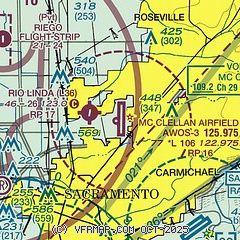
| Sectional chart |
|---|
|
CAUTION: Diagram may not be current
 Download PDF
of official airport diagram from the FAA
| Airport distance calculator |
|---|
|
|
| Sunrise and sunset |
|---|
|
Times for 28-Jul-2026
| | Local
(UTC-7) | | Zulu
(UTC) |
|---|
| Morning civil twilight | | 05:35 | | 12:35 |
| Sunrise | | 06:05 | | 13:05 |
| Sunset | | 20:19 | | 03:19 |
| Evening civil twilight | | 20:49 | | 03:49 |
|
| Current date and time |
|---|
| Zulu (UTC) | 28-Jul-2026 14:51:22 |
|---|
| Local (UTC-7) | 28-Jul-2026 07:51:22 |
|---|
|
| METAR |
|---|
| KMCC | 281435Z AUTO 16005KT 10SM CLR 18/12 A2992 RMK AO2
|
KSMF
10nm W | 281353Z 14006KT 10SM CLR 16/12 A2990 RMK AO2 SLP124 T01610122
|
KMHR
10nm SE | 281435Z AUTO 16005KT 10SM CLR 17/12 A2991 RMK AO2 T01720121 $
|
KSAC
11nm SW | 281353Z 18004KT 10SM CLR 16/12 A2990 RMK AO2 SLP126 T01560122
|
KLHM
15nm N | 281435Z AUTO 16004KT 10SM CLR 18/10 A2992 RMK AO1
|
KEDU
20nm SW | 281440Z AUTO 00000KT 10SM 16/13 A2992 RMK AO1
|
|
| TAF |
|---|
| KMCC | 281120Z 2812/2912 17010KT P6SM SKC FM281700 VRB04KT P6SM SKC FM282100 23006KT P6SM SKC FM290300 20010KT P6SM SKC FM290500 16009KT P6SM SKC
|
KSMF
10nm W | 281120Z 2812/2912 16008KT P6SM SKC FM281800 VRB04KT P6SM SKC FM282200 21005KT P6SM SKC FM290100 17010KT P6SM SKC
|
KMHR
10nm SE | 281120Z 2812/2912 16006KT P6SM SKC FM281600 VRB04KT P6SM SKC FM282200 23008KT P6SM SKC
|
KSAC
11nm SW | 281120Z 2812/2912 17006KT P6SM SKC FM281500 20007KT P6SM SKC FM290700 17005KT P6SM SKC
|
|
| NOTAMs |
|---|
NOTAMs are issued by the DoD/FAA and will open in a separate window not controlled by AirNav.
|
|


