FAA INFORMATION EFFECTIVE 09 JULY 2026
Location
| FAA Identifier: | LEW |
| Lat/Long: | 44-02-54.5020N 070-17-00.6270W
44-02.908367N 070-17.010450W
44.0484728,-70.2835075
(estimated) |
| Elevation: | 287.5 ft. / 87.6 m (surveyed) |
| Variation: | 17W (1995) |
| From city: | 4 miles SW of central business district of the associated city |
| Time zone: | UTC -4 (UTC -5 during Standard Time) |
| Zip code: | 04210 |
Airport Operations
| Airport use: | Open to the public |
| Activation date: | 04/1940 |
| Control tower: | no |
| ARTCC: | BOSTON CENTER |
| FSS: | BANGOR FLIGHT SERVICE STATION |
| NOTAMs facility: | LEW (NOTAM-D service available) |
| Attendance: | 0800-1700 |
| Wind indicator: | lighted |
| Segmented circle: | yes |
| Lights: | ACTVT MALSR RWY 04; REIL RWY 22; HIRL RWY 04/22 & MIRL RWY 17/35 - CTAF. |
| Beacon: | white-green (lighted land airport)
Operates sunset to sunrise. |
| Landing fee: | yes |
Airport Communications
| CTAF/UNICOM: | 122.8 |
| WX AWOS-3PT: | 118.025 (207-783-2806) |
| PORTLAND APPROACH: | 125.5 |
| PORTLAND DEPARTURE: | 125.5 |
| CLEARANCE DELIVERY: | 124.05 ;CTC APCH CTL |
| PRE-TAXI CLEARANCE: | 124.05 ;CTC APCH CTL |
| WX AWOS-3PT at BXM (18 nm SE): | 134.875 (207-409-1747) |
- APCH/DEP SVC PRVDD BY BOSTON ARTCC ON FREQS 128.2 (WATERBORO RCAG) AND 290.50 (BANGOR RCAG) WHEN PORTLAND ATCT CLSD.
Nearby radio navigation aids
| VOR radial/distance | | VOR name | | Freq | | Var |
|---|
| AUGr250/26.5 | | AUGUSTA VOR/DME | | 114.95 | | 18W |
Airport Services
| Fuel available: | 100LL JET-A1+
100LL:FOR FUEL OR SVCS AFT HRS CALL 207-784-6318. |
| Parking: | hangars and tiedowns |
| Airframe service: | MAJOR |
| Powerplant service: | MAJOR |
| Bottled oxygen: | LOW |
| Bulk oxygen: | NONE |
Runway Information
Runway 4/22
| Dimensions: | 5001 x 100 ft. / 1524 x 30 m |
| Surface: | asphalt/grooved, in excellent condition |
| Weight bearing capacity: | | Single wheel: | 30.0 | | Double wheel: | 108.0 | | Double tandem: | 180.0 |
|
| Runway edge lights: | high intensity |
| RUNWAY 4 | | RUNWAY 22 |
| Latitude: | 44-02.534348N | | 44-03.283958N |
| Longitude: | 070-17.283455W | | 070-16.812340W |
| Elevation: | 270.4 ft. | | 263.1 ft. |
| Traffic pattern: | left | | left |
| Runway heading: | 041 magnetic, 024 true | | 221 magnetic, 204 true |
| Markings: | precision, in good condition | | nonprecision, in good condition |
| Visual slope indicator: | 4-light PAPI on left (3.00 degrees glide path) | | 4-light PAPI on left (3.50 degrees glide path) |
| Approach lights: | MALSR: 1,400 foot medium intensity approach lighting system with runway alignment indicator lights | | |
| Runway end identifier lights: | no | | yes |
| Touchdown point: | yes, no lights | | yes, no lights |
| Instrument approach: | ILS/DME | | |
| Obstructions: | 100 ft. trees, 4450 ft. from runway, 450 ft. right of centerline, 42:1 slope to clear | | 62 ft. trees, 849 ft. from runway, 340 ft. right of centerline, 10:1 slope to clear
13 FT POLE 100 FT FM RWY END, 375 FT R, +5 FT ROADWAY 0-200 FT FM RWY END 0-350 FT R. |
Runway 17/35
| Dimensions: | 2750 x 75 ft. / 838 x 23 m |
| Surface: | asphalt, in excellent condition |
| Weight bearing capacity: | |
| Runway edge lights: | medium intensity |
| RUNWAY 17 | | RUNWAY 35 |
| Latitude: | 44-03.098153N | | 44-02.714865N |
| Longitude: | 070-17.108905W | | 070-16.775095W |
| Elevation: | 255.5 ft. | | 287.5 ft. |
| Traffic pattern: | left | | left |
| Runway heading: | 165 magnetic, 148 true | | 345 magnetic, 328 true |
| Markings: | basic, in good condition | | basic, in good condition |
| Runway end identifier lights: | no | | no |
| Touchdown point: | yes, no lights | | yes, no lights |
| Obstructions: | 73 ft. tree, 1508 ft. from runway, 240 ft. left of centerline, 17:1 slope to clear | | 58 ft. tree, 1077 ft. from runway, 199 ft. right of centerline, 15:1 slope to clear |
Airport Ownership and Management from official FAA records
| Ownership: | Publicly-owned |
| Owner: | CITIES OF AUBURN & LEWISTON
80 AIRPORT DR
AUBURN, ME 04210
Phone 207-786-0631 |
| Manager: | JONATHAN LABONTE
80 AIRPORT DR
AUBURN, ME 04210
Phone 207-786-0631
AUBURN CITY TRANSPORTATION DIR. |
Additional Remarks
| - | BIRDS ON & INVOF ARPT. |
| - | RWY 04 DSGND CALM WIND RWY. |
| - | OCNL BLASTING IN PROG MON-SAT APRXLY 4800-5000 FT SW OF RWY 04 THR 1100-1500 DURG VFR CONDS ONLY. |
| - | INTENSIVE HOP DLY FM 0500-2000. HEL TFC PAT 500 AGL, RIGHT TFC. |
| - | ACFT DE-ICING AVBL. |
| - | FOR CD WHEN APCH CLSD CTC BOSTON ARTCC AT 603-879-6859. |
Instrument Procedures
NOTE: All procedures below are presented as PDF files. If you need a reader for these files, you should download the free Adobe Reader.NOT FOR NAVIGATION. Please procure official charts for flight.
FAA instrument procedures published for use from 09 July 2026 at 0901Z to 06 August 2026 at 0900Z.
IAPs - Instrument Approach Procedures |
|---|
| ILS OR LOC RWY 04 | |
download (261KB) |
| RNAV (GPS) RWY 04 | |
download (248KB) |
| RNAV (GPS) RWY 22 | |
download (260KB) |
| NOTE: Special Alternate Minimums apply | |
download (152KB) |
| NOTE: Special Take-Off Minimums/Departure Procedures apply | |
download (510KB) |
Other nearby airports with instrument procedures:
81B - Oxford County Regional Airport (11 nm NW)
KBXM - Brunswick Executive Airport (18 nm SE)
KPWM - Portland International Jetport (24 nm S)
KIWI - Wiscasset Airport (25 nm E)
KAUG - Augusta State Airport (27 nm NE)
|
|

Road maps at:
MapQuest
Bing
Google
| Aerial photo |
|---|
WARNING: Photo may not be current or correct
 Photo by Pete Chaisson Portland Flight Services
Photo taken 19-Jun-2014
looking west.
Photo by Pete Chaisson Portland Flight Services
Photo taken 19-Jun-2014
looking west.
Do you have a better or more recent aerial photo of Auburn/Lewiston Municipal Airport that you would like to share? If so, please send us your photo.
|
| Sectional chart |
|---|
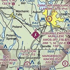
|
CAUTION: Diagram may not be current

| Airport distance calculator |
|---|
|
|
| Sunrise and sunset |
|---|
|
Times for 12-Jul-2026
| | Local
(UTC-4) | | Zulu
(UTC) |
|---|
| Morning civil twilight | | 04:35 | | 08:35 |
| Sunrise | | 05:10 | | 09:10 |
| Sunset | | 20:23 | | 00:23 |
| Evening civil twilight | | 20:58 | | 00:58 |
|
| Current date and time |
|---|
| Zulu (UTC) | 12-Jul-2026 20:11:59 |
|---|
| Local (UTC-4) | 12-Jul-2026 16:11:59 |
|---|
|
| METAR |
|---|
| KLEW | 121956Z AUTO 00000KT 10SM CLR 27/11 A3016 RMK AO2 SLP216 T02720111
|
KBXM
18nm SE | 121955Z AUTO 21012KT 10SM CLR 27/13 A3018 RMK AO2
|
|
| TAF |
|---|
KPWM
24nm S | 121733Z 1218/1318 10007KT P6SM SCT070 FM121900 17008KT P6SM SCT080 FM130000 19005KT P6SM FEW080 SCT250 FM131400 18011KT P6SM FEW060 SCT250
|
|
| NOTAMs |
|---|
NOTAMs are issued by the DoD/FAA and will open in a separate window not controlled by AirNav.
|
|


