FAA INFORMATION EFFECTIVE 14 MAY 2026
Location
| FAA Identifier: | M18 |
| Lat/Long: | 33-43-11.9321N 093-39-32.0534W
33-43.198868N 093-39.534223W
33.7199811,-93.6589037
(estimated) |
| Elevation: | 359.2 ft. / 109.5 m (surveyed) |
| Variation: | 03E (2000) |
| From city: | 4 miles NW of HOPE, AR |
| Time zone: | UTC -5 (UTC -6 during Standard Time) |
| Zip code: | 71801 |
Airport Operations
| Airport use: | Open to the public |
| Activation date: | 07/1944 |
| Control tower: | no |
| ARTCC: | FORT WORTH CENTER |
| FSS: | JONESBORO FLIGHT SERVICE STATION |
| NOTAMs facility: | JBR (NOTAM-D service available) |
| Attendance: | MON-THU 0600-1630
FOR SVC AFT HRS CALL 870-397-1651 |
| Wind indicator: | lighted |
| Segmented circle: | yes |
| Lights: | DUSK-DAWN. REIL & MIRL RY 16/34 OPER DUSK-2200; AFT 2200 ACTVT - CTAF. |
| Beacon: | white-green (lighted land airport)
Operates sunset to sunrise. |
Airport Communications
- APCH/DEP CTL SVC PRVDD BY FORT WORTH ARTCC (ZFW) ON FREQS 123.925/269.475 (TEXARKANA RCAG).
Nearby radio navigation aids
| VOR radial/distance | | VOR name | | Freq | | Var |
|---|
| TXKr052/24.1 | | TEXARKANA VORTAC | | 116.30 | | 07E |
| NDB name | | Hdg/Dist | | Freq | | Var | | ID |
|---|
| HOPE | | at field | | 362 | | 03E | | HPC | .... .--. -.-. |
Airport Services
| Fuel available: | 100LL JET-A
100LL:SELF-SERVE FUEL AVBL 24 HRS (100LL & JET A) |
| Parking: | hangars and tiedowns |
| Airframe service: | NONE |
| Powerplant service: | NONE |
Runway Information
Runway 16/34
| Dimensions: | 5501 x 100 ft. / 1677 x 30 m |
| Surface: | concrete, in good condition |
| Weight bearing capacity: | | Single wheel: | 40.0 | | Double wheel: | 55.0 | | Double tandem: | 105.0 |
|
| Runway edge lights: | medium intensity
NSTD MIRL - LGTS LCTD APRXLY 35 FT FM MARKED RY EDGE. |
| Runway edge markings: | CNTRLN AND THR MKGS FADED. |
| RUNWAY 16 | | RUNWAY 34 |
| Latitude: | 33-43.659208N | | 33-42.773768N |
| Longitude: | 093-39.411795W | | 093-39.176868W |
| Elevation: | 359.2 ft. | | 340.4 ft. |
| Traffic pattern: | left | | left |
| Runway heading: | 164 magnetic, 167 true | | 344 magnetic, 347 true |
| Markings: | nonprecision, in good condition | | numbers only, in good condition |
| Visual slope indicator: | 2-light PAPI on left (3.00 degrees glide path) | | 2-light PAPI on left (3.00 degrees glide path) |
| Runway end identifier lights: | yes | | yes |
| Touchdown point: | yes, no lights | | yes, no lights |
| Obstructions: | 32 ft. tree, 1300 ft. from runway, 330 ft. left of centerline, 34:1 slope to clear | | 29 ft. trees, 1200 ft. from runway, 34:1 slope to clear |
Runway 4/22
| Dimensions: | 5301 x 100 ft. / 1616 x 30 m |
| Surface: | concrete, in fair condition |
| Weight bearing capacity: | | Single wheel: | 40.0 | | Double wheel: | 55.0 | | Double tandem: | 105.0 |
|
| Runway edge markings: | CNTRLN AND THR MKGS FADED. |
| RUNWAY 4 | | RUNWAY 22 |
| Latitude: | 33-42.886167N | | 33-43.475000N |
| Longitude: | 093-40.169667W | | 093-39.396667W |
| Elevation: | 330.0 ft. | | 351.0 ft. |
| Traffic pattern: | left | | left |
| Runway heading: | 045 magnetic, 048 true | | 225 magnetic, 228 true |
| Displaced threshold: | 1190 ft. | | 344 ft. |
| Markings: | nonprecision, in poor condition | | nonprecision, in poor condition |
| Touchdown point: | yes, no lights | | yes, no lights |
| Obstructions: | 50 ft. trees, 250 ft. from runway, 1:1 slope to clear
APCH RATIO FROM DSPLCD THR 28:1. | | none |
Airport Ownership and Management from official FAA records
| Ownership: | Publicly-owned |
| Owner: | CITY OF HOPE
PO BOX 667
HOPE, AR 71802
Phone 870-777-6701 |
| Manager: | DARRELL ALLEN
PO BOX 667
HOPE, AR 71802
Phone 870-777-3444 |
Additional Remarks
| - | FOR CD CTC FORT WORTH ARTCC AT 817-858-7584. |
| - | DEER ON & INVOF ARPT. |
Instrument Procedures
NOTE: All procedures below are presented as PDF files. If you need a reader for these files, you should download the free Adobe Reader.NOT FOR NAVIGATION. Please procure official charts for flight.
FAA instrument procedures published for use from 14 May 2026 at 0901Z to 11 June 2026 at 0900Z.
IAPs - Instrument Approach Procedures |
|---|
| RNAV (GPS) RWY 04 | |
download (209KB) |
| RNAV (GPS) RWY 16 | |
download (211KB) |
| RNAV (GPS) RWY 22 | |
download (197KB) |
| NOTE: Special Take-Off Minimums/Departure Procedures apply | |
download |
Other nearby airports with instrument procedures:
M77 - Howard County Airport (19 nm NW)
KTXK - Texarkana Regional Airport-Webb Field (23 nm SW)
KAGO - Ralph C Weiser Field Airport (37 nm SE)
KADF - Dexter B Florence Memorial Field Airport (37 nm NE)
KDEQ - J Lynn Helms Sevier County Airport (42 nm NW)
|
|

Road maps at:
MapQuest
Bing
Google
| Aerial photo |
|---|
WARNING: Photo may not be current or correct
 Photo by Danny R. Schnautz
Taken in the Spring of 2020
looking north-northwest.
Photo by Danny R. Schnautz
Taken in the Spring of 2020
looking north-northwest.
Do you have a better or more recent aerial photo of Hope Municipal Airport that you would like to share? If so, please send us your photo.
|
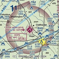
| Sectional chart |
|---|
|
| Airport distance calculator |
|---|
|
|
| Sunrise and sunset |
|---|
|
Times for 04-Jun-2026
| | Local
(UTC-5) | | Zulu
(UTC) |
|---|
| Morning civil twilight | | 05:37 | | 10:37 |
| Sunrise | | 06:05 | | 11:05 |
| Sunset | | 20:21 | | 01:21 |
| Evening civil twilight | | 20:49 | | 01:49 |
|
| Current date and time |
|---|
| Zulu (UTC) | 04-Jun-2026 22:40:58 |
|---|
| Local (UTC-5) | 04-Jun-2026 17:40:58 |
|---|
|
| METAR |
|---|
KTXK
23nm SW | 042203Z 00000KT 10SM -RA FEW060 SCT075 BKN095 23/22 A3003 RMK AO2 LTG DSNT N P0000 T02330222 $
|
KAGO
37nm SE | 042215Z AUTO 00000KT 10SM CLR 27/23 A3000 RMK A01
|
KADF
37nm NE | 042155Z AUTO 00000KT 10SM FEW041 SCT180 BKN210 27/23 A3001 RMK AO2 RAB17E45 SLP161 T02720233
|
KDEQ
42nm NW | 042153Z AUTO 11007KT 10SM CLR 25/23 A3000 RMK AO2 LTG DSNT SE RAB02E15 SLP156 P0000 T02500228
|
KCDH
45nm E | 042215Z AUTO 13005KT 10SM CLR 28/21 A3001 RMK AO2 T02800209 $
|
KATA
46nm SW | 042215Z AUTO RMK AO2 PWINO TSNO $
|
|
| TAF |
|---|
KTXK
23nm SW | 042124Z 0421/0518 15010KT 2SM +TSRA BR FEW009 BKN040CB OVC090 TEMPO 0421/0422 VRB14G26KT 1SM +TSRA BKN015 OVC040CB FM042200 13006KT P6SM VCTS SCT040CB OVC100 FM050000 12007KT P6SM FEW040 SCT120 BKN250 FM050600 14005KT P6SM OVC025 FM051200 15005KT 6SM BR OVC015
|
|
| NOTAMs |
|---|
NOTAMs are issued by the DoD/FAA and will open in a separate window not controlled by AirNav.
|
|

