FAA INFORMATION EFFECTIVE 30 OCTOBER 2025
Location
| FAA Identifier: | M77 |
| Lat/Long: | 33-59-49.9000N 093-50-17.1000W
33-59.831667N 093-50.285000W
33.9971944,-93.8380833
(estimated) |
| Elevation: | 553.1 ft. / 168.6 m (surveyed) |
| Variation: | 02E (2010) |
| From city: | 3 miles N of NASHVILLE, AR |
| Time zone: | UTC -6 (UTC -5 during Daylight Saving Time) |
| Zip code: | 71852 |
Airport Operations
| Airport use: | Open to the public |
| Activation date: | 03/1969 |
| Control tower: | no |
| ARTCC: | FORT WORTH CENTER |
| FSS: | JONESBORO FLIGHT SERVICE STATION |
| NOTAMs facility: | JBR (NOTAM-D service available) |
| Attendance: | UNATNDD |
| Wind indicator: | lighted |
| Segmented circle: | no |
| Lights: | ACTVT MIRL RWY 01/19 & PAPI RWYS 01 & 19 - CTAF. |
| Beacon: | white-green (lighted land airport)
Operates sunset to sunrise. |
Airport Communications
- APCH/DEP CTL SVC PRVDD BY FORT WORTH ARTCC (ZFW) ON FREQS 123.925/269.475 (TEXARKANA RCAG).
Nearby radio navigation aids
| VOR radial/distance | | VOR name | | Freq | | Var |
|---|
| TXKr015/31.3 | | TEXARKANA VORTAC | | 116.30 | | 07E |
| NDB name | | Hdg/Dist | | Freq | | Var | | ID |
|---|
| HOPE | | 328/19.2 | | 362 | | 03E | | HPC | .... .--. -.-. |
Airport Services
| Fuel available: | 100LL
100LL:SELF SERVE FUEL AVBL 24 HRS. |
| Parking: | tiedowns |
| Airframe service: | NONE |
| Powerplant service: | NONE |
| Bottled oxygen: | NONE |
| Bulk oxygen: | NONE |
Runway Information
Runway 1/19
| Dimensions: | 3994 x 75 ft. / 1217 x 23 m |
| Surface: | asphalt, in fair condition |
| Weight bearing capacity: | |
| Runway edge lights: | medium intensity |
| Runway edge markings: | MARKINGS FADED RWY 19 |
| RUNWAY 1 | | RUNWAY 19 |
| Latitude: | 33-59.510368N | | 34-00.154427N |
| Longitude: | 093-50.366967W | | 093-50.202617W |
| Elevation: | 528.5 ft. | | 549.6 ft. |
| Traffic pattern: | left | | left |
| Runway heading: | 010 magnetic, 012 true | | 190 magnetic, 192 true |
| Displaced threshold: | 115 ft. | | no |
| Markings: | nonprecision, in poor condition | | nonprecision, in poor condition |
| Visual slope indicator: | 2-light PAPI on left (3.00 degrees glide path) | | 2-light PAPI on left (3.00 degrees glide path) |
| Touchdown point: | yes, no lights | | yes, no lights |
| Obstructions: | 40 ft. trees, 1650 ft. from runway, 525 ft. right of centerline, 36:1 slope to clear
+3 FT FENCE 183 FT FROM RWY END. | | 15 ft. trees, 500 ft. from runway, 95 ft. left of centerline, 20:1 slope to clear |
Airport Ownership and Management from official FAA records
| Ownership: | Publicly-owned |
| Owner: | HOWARD COUNTY
421 N. MAIN
NASHVILLE, AR 71852
Phone 870-845-7500 |
| Manager: | MARK WILEY
421 N MAIN
NASHVILLE, AR 71852
Phone 870-904-0733 |
Additional Remarks
| - | RY 01 FENCE 3 FT AND ROAD 7 FT BELOW THLD 200 FT FM RY END. |
| - | RY 19 TURNAROUND HAS A 10 FT DROP OFF. |
| - | FOR CD CTC FORT WORTH ARTCC AT 817-858-7584. |
Instrument Procedures
NOTE: All procedures below are presented as PDF files. If you need a reader for these files, you should download the free Adobe Reader.NOT FOR NAVIGATION. Please procure official charts for flight.
FAA instrument procedures published for use from 30 October 2025 at 0901Z to 27 November 2025 at 0900Z.
IAPs - Instrument Approach Procedures |
|---|
| RNAV (GPS) RWY 01 | |
download (188KB) |
| RNAV (GPS) RWY 19 | |
download (198KB) |
| NOTE: Special Take-Off Minimums/Departure Procedures apply | |
download (131KB) |
Other nearby airports with instrument procedures:
M18 - Hope Municipal Airport (19 nm SE)
KDEQ - J Lynn Helms Sevier County Airport (28 nm W)
KTXK - Texarkana Regional Airport-Webb Field (33 nm S)
KMEZ - Mena Intermountain Municipal Airport (38 nm NW)
KADF - Dexter B Florence Memorial Field Airport (39 nm E)
|
|

Road maps at:
MapQuest
Bing
Google
| Aerial photo |
|---|
WARNING: Photo may not be current or correct
 Photo courtesy of the Arkansas Department of Aeronautics
Taken in the Spring of 2007
Photo courtesy of the Arkansas Department of Aeronautics
Taken in the Spring of 2007
Do you have a better or more recent aerial photo of Howard County Airport that you would like to share? If so, please send us your photo.
|
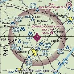
| Sectional chart |
|---|
|
| Airport distance calculator |
|---|
|
|
| Sunrise and sunset |
|---|
|
Times for 26-Nov-2025
| | Local
(UTC-6) | | Zulu
(UTC) |
|---|
| Morning civil twilight | | 06:32 | | 12:32 |
| Sunrise | | 06:59 | | 12:59 |
| Sunset | | 17:06 | | 23:06 |
| Evening civil twilight | | 17:33 | | 23:33 |
|
| Current date and time |
|---|
| Zulu (UTC) | 26-Nov-2025 07:01:53 |
|---|
| Local (UTC-6) | 26-Nov-2025 01:01:53 |
|---|
|
| METAR |
|---|
KDEQ
28nm W | 260653Z AUTO 00000KT 1SM BR VV002 07/07 A3019 RMK AO2 SLP222 T00670067
|
KTXK
34nm S | 260653Z AUTO 32005KT 10SM CLR 12/11 A3019 RMK AO2 SLP221 T01220106
|
KMWT
35nm N | 260653Z AUTO 31008KT 10SM CLR 12/05 A3017 RMK AO2 SLP213 T01170050
|
KMEZ
38nm NW | 260655Z AUTO 32007KT 10SM CLR 10/04 A3021 RMK AO2 T01000037
|
KADF
39nm E | 260655Z AUTO 29003KT 10SM CLR 10/08 A3018 RMK AO2 SLP218 T 01000083 PNO FZRANO
|
KHOT
47nm NE | 260653Z AUTO 31003KT 10SM CLR 11/09 A3018 RMK AO2 SLP216 T01060089 $
|
|
| TAF |
|---|
KTXK
34nm S | 260520Z 2606/2706 34010KT P6SM FEW040 SCT250 FM261500 35012G18KT P6SM SCT250 FM262300 32004KT P6SM SCT100 BKN250
|
KADF
39nm E | 260527Z 2606/2706 33008G15KT P6SM SKC FM261200 33008G18KT P6SM SKC FM262100 33007KT P6SM FEW250
|
|
| NOTAMs |
|---|
NOTAMs are issued by the DoD/FAA and will open in a separate window not controlled by AirNav.
|
|

