FAA INFORMATION EFFECTIVE 19 FEBRUARY 2026
Location
| FAA Identifier: | M73 |
| Lat/Long: | 34-24-44.9260N 091-27-55.1000W
34-24.748767N 091-27.918333W
34.4124794,-91.4653056
(estimated) |
| Elevation: | 210.2 ft. / 64.1 m (surveyed) |
| Variation: | 02E (2000) |
| From city: | 3 miles W of ALMYRA, AR |
| Time zone: | UTC -6 (UTC -5 during Daylight Saving Time) |
| Zip code: | 72003 |
Airport Operations
| Airport use: | Open to the public |
| Control tower: | no |
| ARTCC: | MEMPHIS CENTER |
| FSS: | JONESBORO FLIGHT SERVICE STATION |
| NOTAMs facility: | JBR (NOTAM-D service available) |
| Attendance: | MON-FRI 0800-1700 |
| Wind indicator: | lighted |
| Segmented circle: | yes |
| Lights: | ACTVT MIRL RY 18/36, PAPI RYS 18 & 36 - CTAF. |
| Beacon: | white-green (lighted land airport)
Operates sunset to sunrise. |
Airport Communications
| CTAF/UNICOM: | 123.0 |
| LITTLE ROCK APPROACH: | 119.85 |
| LITTLE ROCK DEPARTURE: | 119.85 |
| CLEARANCE DELIVERY: | 119.85 |
| WX AWOS-3PT at SGT (12 nm NW): | 119.025 (870-673-1884) |
Nearby radio navigation aids
| VOR radial/distance | | VOR name | | Freq | | Var |
|---|
| PBFr062/24.9 | | PINE BLUFF VOR/DME | | 116.00 | | 04E |
Airport Services
| Fuel available: | 100LL
100LL:100 LL SELF SERVE AVBL WITH CREDIT CARD. FOR SVC AFT HRS CALL 870-830-1231. |
| Parking: | tiedowns |
| Airframe service: | MINOR |
| Powerplant service: | MINOR |
| Bottled oxygen: | NONE |
| Bulk oxygen: | NONE |
Runway Information
Runway 18/36
| Dimensions: | 3494 x 60 ft. / 1065 x 18 m |
| Surface: | asphalt, in fair condition |
| Weight bearing capacity: | |
| Runway edge lights: | medium intensity |
| Runway edge markings: | RWY 18 MARKINGS FADED |
| RUNWAY 18 | | RUNWAY 36 |
| Latitude: | 34-24.941108N | | 34-24.365080N |
| Longitude: | 091-28.046473W | | 091-28.053110W |
| Elevation: | 208.8 ft. | | 203.1 ft. |
| Traffic pattern: | left | | left |
| Runway heading: | 179 magnetic, 181 true | | 359 magnetic, 001 true |
| Displaced threshold: | 38 ft. | | no |
| Markings: | basic, in poor condition | | nonprecision, in fair condition |
| Visual slope indicator: | 2-light PAPI on right (3.00 degrees glide path) | | 2-light PAPI on left (3.00 degrees glide path) |
| Touchdown point: | yes, no lights | | yes, no lights |
| Obstructions: | 15 ft. road, 450 ft. from runway, 16:1 slope to clear
RWY 18 APCH RATIO FROM DSPLCD THLD 32:1 | | none |
Runway 10/28
| Dimensions: | 3000 x 50 ft. / 914 x 15 m |
| Surface: | asphalt, in fair condition |
| Weight bearing capacity: | |
| RUNWAY 10 | | RUNWAY 28 |
| Latitude: | 34-24.926793N | | 34-24.793618N |
| Longitude: | 091-28.052600W | | 091-27.477865W |
| Elevation: | 208.9 ft. | | 204.1 ft. |
| Traffic pattern: | left | | left |
| Runway heading: | 104 magnetic, 106 true | | 284 magnetic, 286 true |
| Markings: | basic, in fair condition | | basic, in fair condition |
| Touchdown point: | yes, no lights | | yes, no lights |
| Obstructions: | none
10 FT GRVL ROAD 0 FT FM THLD. | | 20 ft. trees, 540 ft. from runway, 115 ft. right of centerline, 17:1 slope to clear |
Airport Ownership and Management from official FAA records
| Ownership: | Publicly-owned |
| Owner: | CITY OF ALMYRA
P O BOX 213
ALMYRA, AR 72003
Phone 870-673-1591 |
| Manager: | MARK HARTZ
275 ALMYRA AIRPORT ROAD
ALMYRA, AR 72003
Phone (870) 830-1231 |
Additional Remarks
| A39-18/36 | PCR VALUE: 80/F/C/X/T |
| - | MIGRATORY BIRDS ON & INVOF AIRPORT NOV-FEB |
| - | NUMEROUS AGRICULTURAL ACFT OPNS |
| - | FOR CD WHEN UNA VIA FREQ CTC LITTLE ROCK APCH 501-379-2908 OR LITTLE ROCK ATCT 501-379-2911 |
Instrument Procedures
NOTE: All procedures below are presented as PDF files. If you need a reader for these files, you should download the free Adobe Reader.NOT FOR NAVIGATION. Please procure official charts for flight.
FAA instrument procedures published for use from 19 February 2026 at 0901Z to 19 March 2026 at 0900Z.
IAPs - Instrument Approach Procedures |
|---|
| RNAV (GPS) RWY 36 | |
download (245KB) |
| NOTE: Special Take-Off Minimums/Departure Procedures apply | |
download (131KB) |
Other nearby airports with instrument procedures:
5M1 - Dewitt Municipal Airport/Whitcomb Field (12 nm SE)
KSGT - Stuttgart Municipal Airport / Carl Humphrey Field (12 nm NW)
4M3 - Carlisle Municipal Airport (27 nm NW)
KPBF - Pinebluff Regional Airport/Grider Field (27 nm SW)
M36 - Frank Federer Memorial Airport (31 nm NE)
|
|

Road maps at:
MapQuest
Bing
Google
| Aerial photo |
|---|
WARNING: Photo may not be current or correct
 Photo courtesy of the Arkansas Department of Aeronautics
Taken in the Spring of 2007
Photo courtesy of the Arkansas Department of Aeronautics
Taken in the Spring of 2007
Do you have a better or more recent aerial photo of Almyra Municipal Airport that you would like to share? If so, please send us your photo.
|
| Sectional chart |
|---|
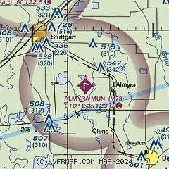
|
| Airport distance calculator |
|---|
|
|
| Sunrise and sunset |
|---|
|
Times for 20-Feb-2026
| | Local
(UTC-6) | | Zulu
(UTC) |
|---|
| Morning civil twilight | | 06:21 | | 12:21 |
| Sunrise | | 06:47 | | 12:47 |
| Sunset | | 17:53 | | 23:53 |
| Evening civil twilight | | 18:18 | | 00:18 |
|
| Current date and time |
|---|
| Zulu (UTC) | 20-Feb-2026 19:05:04 |
|---|
| Local (UTC-6) | 20-Feb-2026 13:05:04 |
|---|
|
| METAR |
|---|
KSGT
12nm NW | 201856Z AUTO 36006KT 10SM BKN085 14/M01 A2997 RMK AO2 SLP149 T01391006 $
|
|
| TAF |
|---|
KPBF
27nm SW | 201720Z 2018/2118 02009KT P6SM SCT250 FM202300 06007KT P6SM OVC050 FM210200 04006KT P6SM -SHRA OVC025 FM210600 03008KT P6SM OVC025 FM211200 02006KT P6SM OVC050
|
|
| NOTAMs |
|---|
NOTAMs are issued by the DoD/FAA and will open in a separate window not controlled by AirNav.
|
|

